
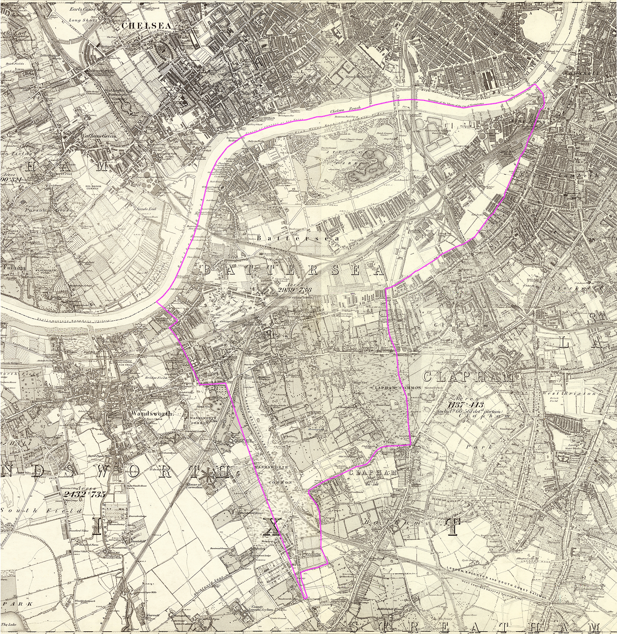
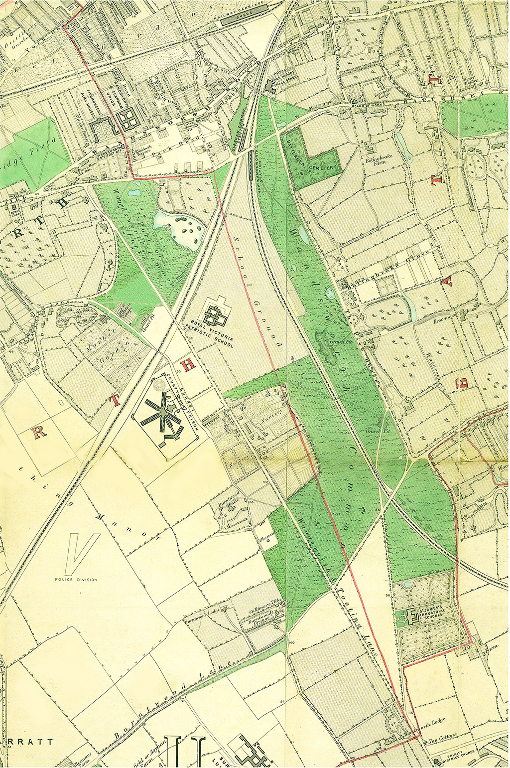
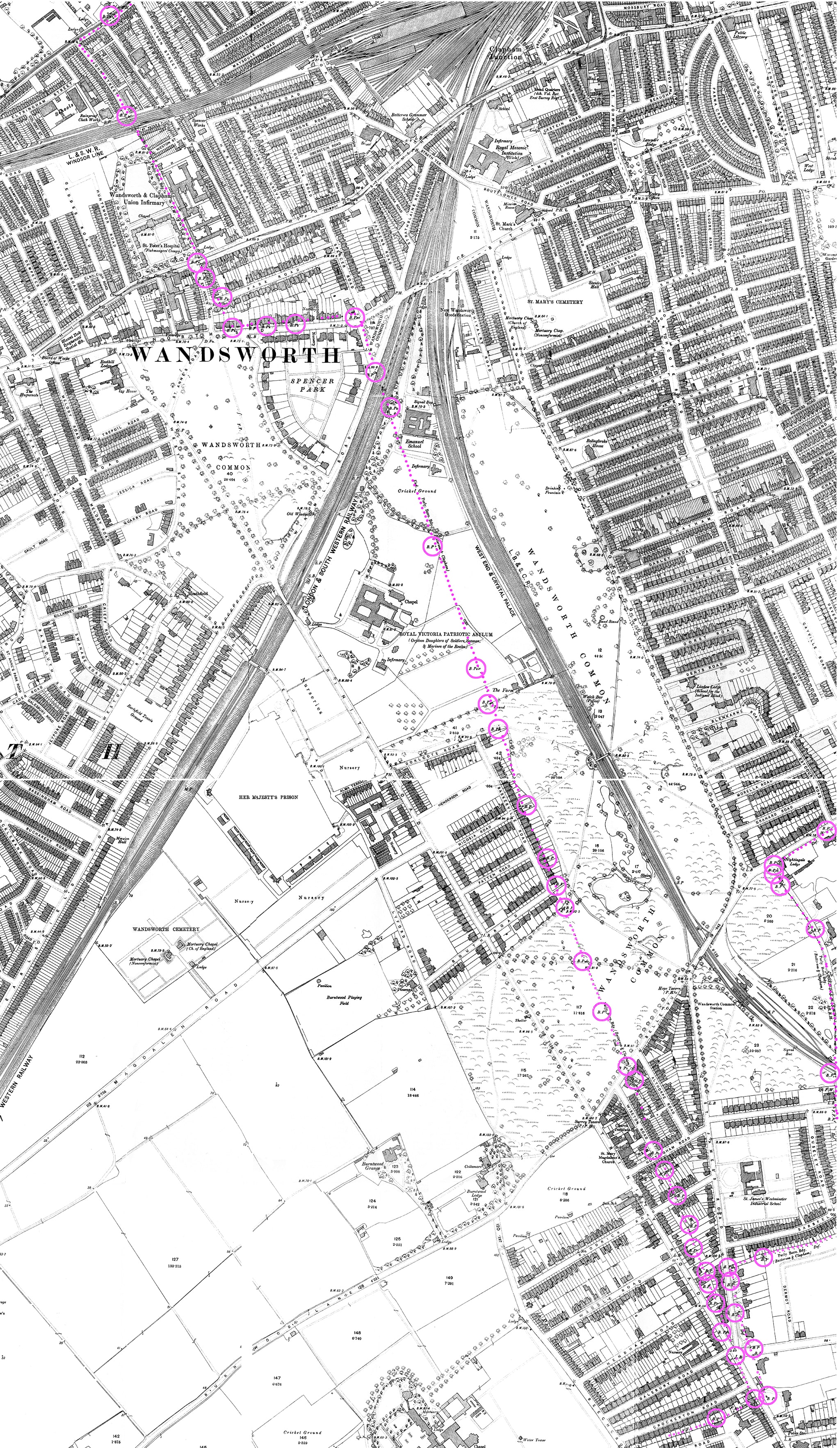
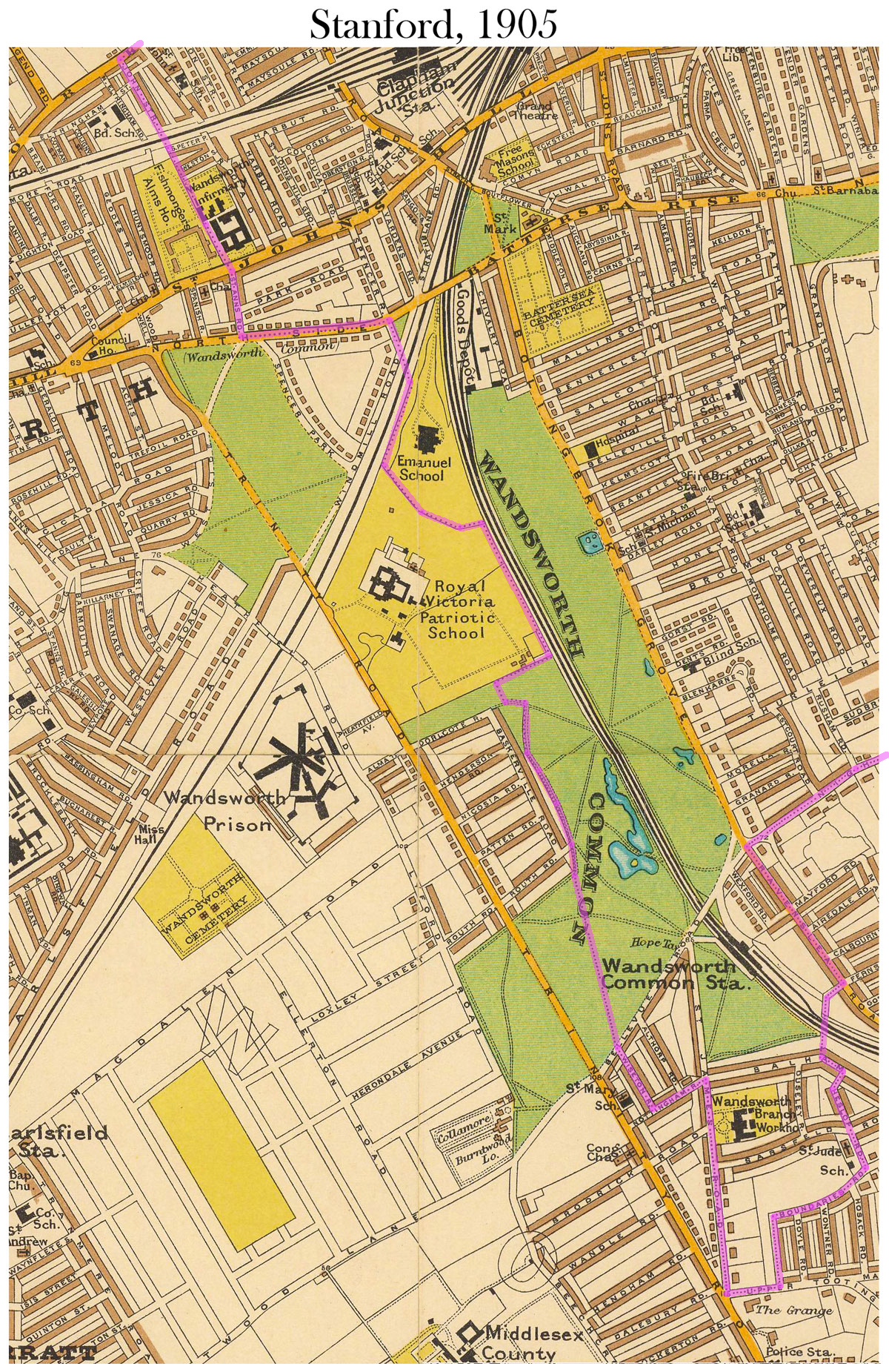
I've highlighted the perambulation on Stanford's 6-inch Library Map of London 1862. The walk proceeds clockwise, in customary fashion, beginning and ending near the parish church of St Mary's.
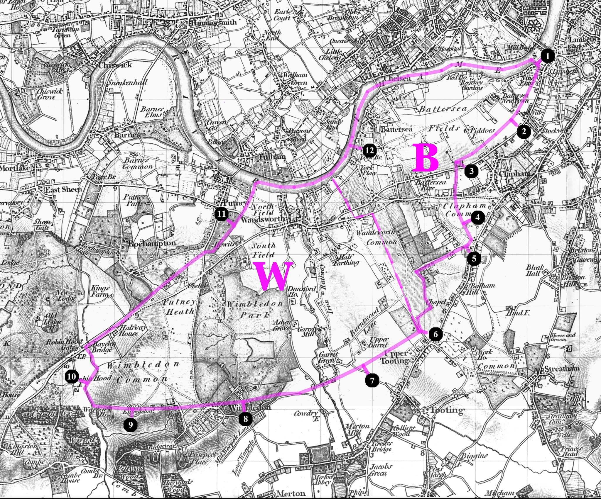
A more detailed view than Stanford's, containing very precise information about the boundary's position with respect to landmarks. [To follow up...]
[from Angus Winchester, Discovering Parish Boundaries, 1990, pp.35-36]
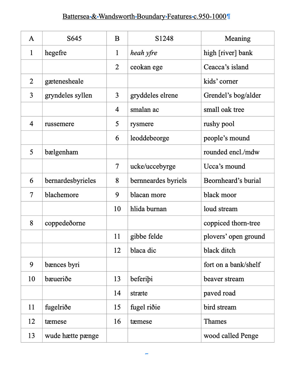
1. Following watercourses
C.S. — centre of stream
S.S. — side of stream
S.D. — side of drain
2. Following roads
C.R. — centre of road
3. Following field boundaries
S.F. — side of fence
F.C. — face of cop (i.e. hedge bank)
R.H. — root of hedge
F.W. — face of wall
C.F. — centre of fence
T.C. — top of cop
C.W. — centre of wall
4. Across open land
Def. — defaced [means follows the line of a feature that used to be present but has now been lost e.g. an old fence, wall, hedgerow, drain, stream etc.]
T.S. — track of stream Und. — Undefined
[What do the double dashed lines on sections of the boundary crossing Clapham Common mean? Do they enclose a stream? The remnants of the famous ditch? What do the letters "C.D." alongside these double dashed lines meaning? (SD means Side of Drain, SS means Side of Stream. Could it mean "Centre of Drain"?) And what does the symbol of two open circles joined by a straight line mean - I think it may appear at many? most? all changes from one type of boundary to another - is that what it means? I think so.]
[Interesting comments on Mappa-Mercia site:]
1.22m RH – RH stands for Root of Hedge, and 1.22m equates to exactly 4ft. The boundary is therefore 4ft away from the stem line of the hedge. This unusual convention comes from the presumption that landowners planted hedgerows slightly in from the edge of their land so as to not encroach on their neighbours plots. The distance differs between 3ft and 5ft depending on which parish the land lies within.
Def – This is a “defaced boundary”, meaning that the original feature that the boundary was aligned to no longer exists. This was probably a hedge that was removed when the houses were built. Had the hedge roots not been removed then the boundary would be marked as “Tk H” implying track of hedge.
Und – An “undefined boundary” is one where there was no real-world feature to align the boundary to when it was surveyed.
[Source: When is a boundary not a boundary?.]
Some years ago, Sean Creighton and Roger Logan sent me a treasure trove of newspaper cuttings featuring John Buckmaster, among which was this gem — a "perambulation" or "beating of the bounds" that Buckmaster and others made around Battersea in 1862. I am very grateful to Sean and Roger for passing the articles on.
To make the transcript easier to follow, I've broken the text up into shorter paragraphs and added numbers to help show where the action is taking place on the map. If you click on these numbers you should be taken to the related notes and commentary.
This is a work in progress, so if you can add (or subtract) anything, please do.

BEATING THE BOUNDS IN BATTERSEA, May 1862.
On Holy Thursday, according to triennial custom, the parochial officers of Battersea, accompanied by a large number of boys taken from the various schools, perambulated the bounds of the parish [Start . . . ]
The muster took place in Battersea-square [1], about nine o'clock in the morning; and after the boys were formed in procession, with white wands, the parochial officers and others proceeded along the water's edge to Battersea-bridge [2], and from thence along the river to the Railway Dock, at Nine Elms [5].
We may here remark that half the new Suspension and Railway-bridges were included in the journey [3], and an old foot-path leading past the Waterworks was re-opened [4]. Some doubt exists as to whether this path, which was a great convenience and a pleasant walk, could be legally closed without the consent or knowledge of the parochial authorities. This was one of the many things put down in the memoranda to be enquired into.
From the Dock the party (which had now considerably increased) proceeded through the Railway works [5] across the line to the edge of a very black, dirty-looking ditch, which divides the parish of Battersea from Lambeth [6].
Pursuing this open sewer along the low meadow-land you arrive at a place called "Pays bas, " or the low country, which consists of a few houses, about a stone's throw from the Wandsworth-road, which we now enter through a white gate, cross the road, and ascend Wicke's-lane [7], and this forms the eastern boundary of the parish.
From the top of Wicke's-lane you bear in a south-easterly direction across Clapham Common [8] nearly to the corner of the Balham-road, and in a wall which divides the front gardens of two large gentlemen's homes you find a stone, almost hidden with ivy, with the significant initials, "B.P."
From this point you pass along the front gardens of all the houses on the south side of Nightingale-lane [9]. A row of old pollard oaks forms, in fact, the boundary lines at the road and about half of all the front gardens are in Battersea parish, and the houses in Streatham.
The journey across Clapham Common was rather difficult; the old boundary posts have either been removed or perished, but some knowing fellows who accompanied the expedition enabled the parochial officers to decide on those points, where good and substantial marks should be placed. This went down in the book, with the footpath.
At the Wandsworth Common end of Nightingale-lane you see a respectable white-looking house, just painted inside and out [10]. Part of this house is in Battersea parish, and when the army collected in a confused heap before the front door, the servant, in her own expressive language, "wondered what was up."
The Churchwarden and Vestry Clerk were admitted, and the boys, who like seeing the inside of strange houses, were rather disappointed.
The conspicuous white post at the corner was impressed on the memory by the usual bumping, which, at various points, had distinguished the day's proceedings; and it is worthy of remark that twenty-five years ago the present Bishop of Bath and Wells cheerfully underwent the proper bumping at this spot. But in these degenerate days no clergyman accompanied the parish officers and little boys on this festive occasion, or gave by their presence that friendly counsel which all expect but few receive.
From this post the journey proceeds to the south of the St. James's Industrial School [11], and in a delightful green lane, not like the one in Battersea, the boys and men seated themselves on the grass, and were plentifully supplied with cold ham and beef and bread and cheese, with a little wholesome beer.
This was the great event of the day; how the little fellows did eat! it really gives a good-natured man a great deal of pleasure to see such a sight. The Churchwarden was laughing and saying good-natured things to the boys, and telling them to eat away.
But how rapidly the party increases at such a time. Suddenly you find great numbers of persons ready to join in the eating. Where do they come from? Surely a common cannot produce them? but there they are all declaring most solemnly they had been with the party all day, although it is the first time you ever saw them.
The rural dinner over, the churchwarden's health was drank in good spirit. This was not the time or the audience for speechifying, so Mr. Walton just thanked them for their kindness, and the party then proceeded just to the side of Mr. McKellar's front gate [12]
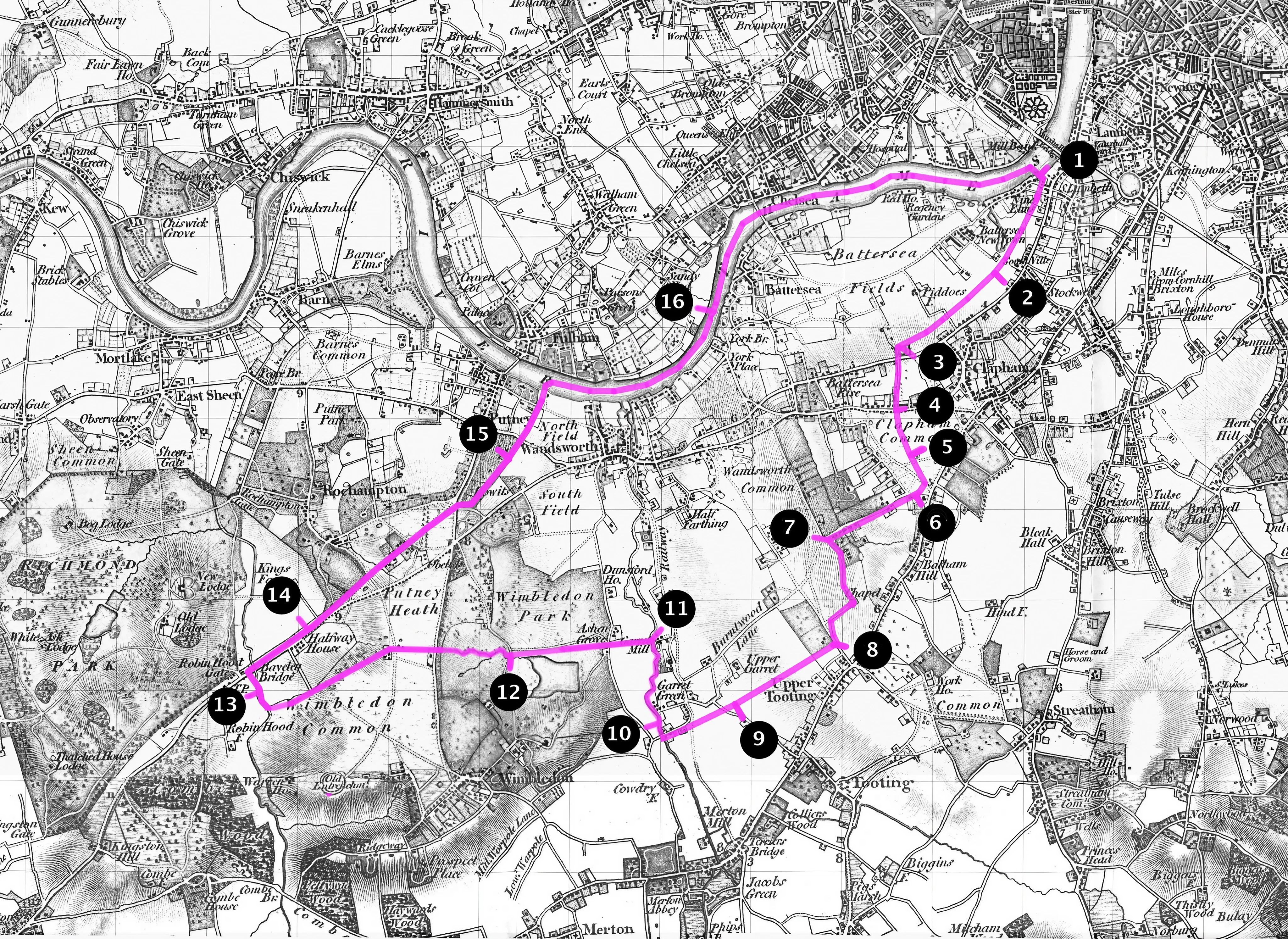
Here they sung "God save the Queen, " and then proceeded across the common [13], to about two hundred yards below the Clapham Common station [14]; here they crossed the line, and continued along the black fence into the road, and from there to the west side of the Union workhouse [15]. The wall dividing the Union from the Fishmongers Almshouses forms part of the western boundary of the parish.
Continuing this line across the Richmond Railway [16], into the Wandsworth-road, and from there down a lane on the east side of the Distillery [17] to the Thames, into Battersea-square [18], forms a general descriptive outline of the home bounds of the parish of Battersea.
The day was everything that could be wished, and there was no disagreeableness during the whole time.
After about eight hours the party arrived at the spot from which they started [18]. Mrs. Walton provided cake and tea for a number of the boys in the evening.
Among the party we noticed Mr. Perry, the churchwarden of St. George's, the school-master, Messrs. Poupart, Juer, W. Griffin, Buckmaster, and others.
What is a "perambulation" or "beating of the bounds"?
There are many accounts of perambulations online. One of the most informative is "Beating the Cholesbury Bounds" — Cholesbury-cum-St Leonards is a village in the Chilterns in Buckinghamshire, ten miles from John Buckmaster's birthplace of Slapton).
Here is an extract:
The custom of 'beating the bounds' has existed in Britain for well over 2000 years. Precise origins are unclear although it can be found as part of ritual celebration within many different cultures across Europe and beyond. In simple terms it involves people in the locality perambulating their farm, manorial, church or civil boundaries pausing as they pass certain trees, walls and hedges that denote the extent of the boundary to exclaim, pray and ritually 'beat' particular landmarks with sticks.
These sticks would originally have been of birch or willow, both being of significance to pre-Christian tribes. Birch has connection with besoms, which have ancient connections with pagan festivals however the willow possessing a close association with water appears to have predominated in medieval times. The sticks were known as rods or wands. The bark was removed exposing the white wood beneath. The English folk-song "Stripping The Willow" is a relatively modern record of these practices.
Such processions would typically occur every seven or ten years. Apart from any religious significance in a time when literacy or map-reading were not widespread skills these inspections served to ensure boundaries remained intact, were known by local people and had not been sequestrated by neighbouring landowners.
Other activities associated with these processional, religious or secular rituals have also survived. Most frequently, at certain points on the boundary, young boys were held upside down and had their heads bumped on a marker stone.
In past times adolescent boys might also be 'switched' (i.e. hit with the willow wands), thrown over hedges, into brambles or ponds or required to climb up chimneys or over roofs. These actions may have originally had a darker antecedents but in more recent times ensured the imprinting of the exact location of a boundary by successive generations of that community.
[Cholesbury.com Beating the Chosebury Bounds (accessed 3 May 2023).]
The perambulation of Battersea . . .
This perambulation or beating of the bounds was intended to define the boundaries of the parish of St Mary's Battersea, in order to assert the scale and integrity of Battersea not just as a religious entity, but (probably mainly) as a social and political one at a time of great change. Your parish was an important source of local identity.
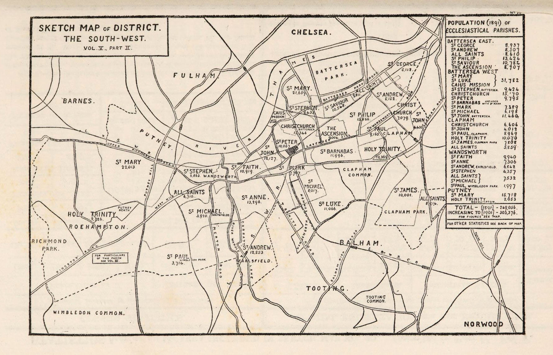
Battersea parish is very ancient — probably Anglo-Saxon in origin, so perhaps more than 1300 years old. Today there are numerous parishes in southwest London, each with its own parish church. But it appears that before the Norman Conquest there was just one large manorial estate stretching from today's Vauxhall in the east to Wimbledon Common in the west (perhaps as far as Beverley Brook).
Battersea at that time included today's Wandsworth. Let's call it, "Battersea-cum-Wandsworth".
[There have been several attempts to map Battersea-cum-Wandsworth's Anglo-Saxon bounds (as described in perambulations of 693 CE and another of c.957 CE), for example by Keith Bailey, Graham Gower, and Nick Fuentes. You can see these, and the spirited arguments they engendered, in a number of editions of the indispensable The Wandsworth Historian (e.g. nos. 3, 43, 58, 59, 60, 65, 69, 74, 87). Fascinating, if sometimes breathtakingly obscure.
Battersea is mentioned in the few surviving Anglo-Saxon geographical accounts as Badrices īeg [??], 'Badric's Island' and later Old English: Patrisey.
Some people think it was already in place 1500 years ago when early Anglo-Saxon Christians may have written about it in the Charter of year that gave Battersea to the nuns of Barking Abbey
There are two charters, from 693CE and c.957...
From KB's unpublished draft:
The story began when a 68-hide estate covering all of Battersea and Wandsworth east of the Wandle was granted to Eorcenwald bishop of London by king Cædwalla of Wessex c.685 and confirmed by Æthelred of Mercia in 693. The estate formed part of the endowment of the nunnery at Barking and comprised three distinct components: Battersea (28 hides), Wassingham (20 hides) and 20 hides ‘west of the Hidaburna’ (modern Falcon Brook). Barking later lost the estate, probably in the late-ninth century.
It returned to royal control until 1067 when William I exchanged it for Windsor with Westminster Abbey.
At some time, probably in the tenth century, two boundary perambulations were made of this estate plus Wandsworth west of the Wandle and parts of Wimbledon and Putney. Confusingly, as detailed boundary surveys were unknown in the 7th century, one of them appears in the much later copy of the Barking charter preserved at Westminster, sandwiched in the two-part witness-list.
The second perambulation is appended to a completely unrelated grant of land near Hendon to Westminster dated 957. Most of the landmarks appear in both sets of bounds, which are probably of mid-late tenth-century date.
Keith has recently revisited the debate and proposed two possible boundaries (as yet unpublished paper, personal correspondence). More on these another time.]
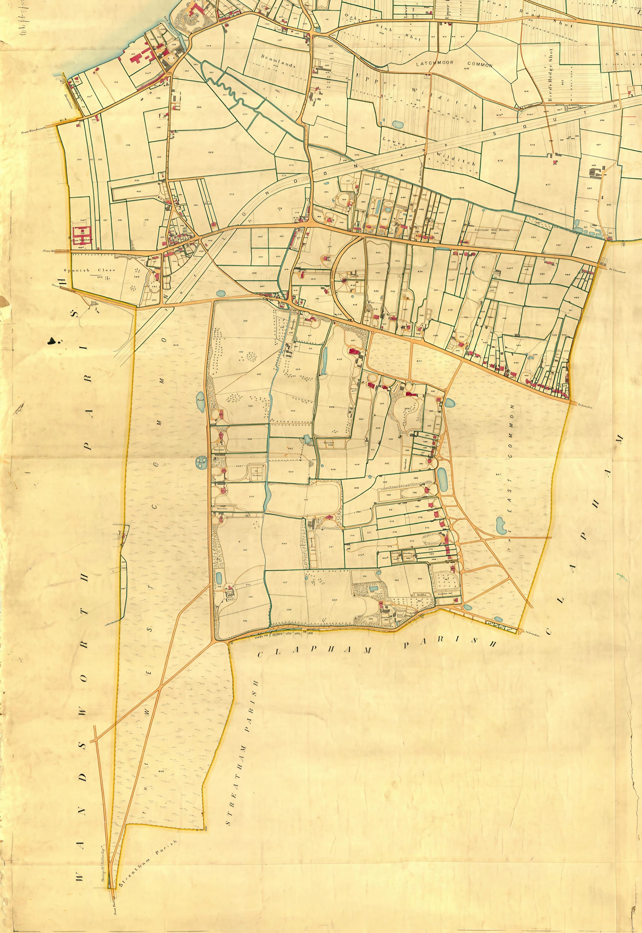
[From then until] early in the nineteenth century the larger manor itself was subdivided (for example, "Allfarthing", "Doune", and other small manors were carved out too) but there were still only two parishes: St Mary's in Battersea and All Saints in Wandsworth.


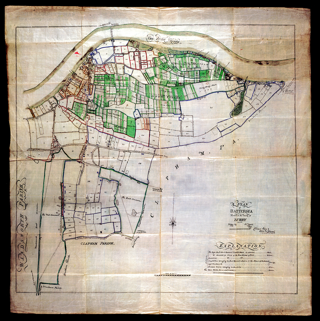
The parish had been mapped (by John Corris) in extraordinary detail for principal landowner Earl Spencer in 1787, and surveyed again in 1838 to meet the obligations of the Tithe Commutation Act of 1836.
,
On Penge . . .
Graham Jackson has reminded me that Penge (roughly today's Penge/Anerley/Crystal Palace area) was once part of Battersea parish — albeit many miles away.

I can't discuss it in any detail now, but it would make an interesting story. This "exclave" was heavily forested (it was part of the "Great North Wood" that gave its name to Norwood), and therefore of vital economic importance to the main area of Battersea. It ceased to be part of Battersea in 1900 [check — sources vary].
'Pen' in a place name, like Penge, Pendleton or Penrith, usually comes from the Celtic for hill or headland.
Sources on Penge to follow up include (there are doubtless many more):
— PengePast: "Touching the Comon [sic] of Penge" (probably the best reference).
— Wikipedia: Penge
— Wikipedia: Penge Urban District
— Transpont: Beating Bounds in Penge and Blackheath.
— DiamondGeezer: A Walk around the rim of Penge
— PengePast: Where was Penge?.
— Sydenham.org.uk: Making sense of Penge Common.
— There are a number of photographs of Penge boundary markers bearing the name "Battersea" in Inside Croydon: Eight Walks to encompass Croysdon's Boundaries.]
"On Holy Thursday, according to triennial custom . . . "
BEATING THE BOUNDS IN BATTERSEA.
On Holy Thursday, according to triennial custom, the parochial officers of Battersea, accompanied by a large number of boys taken from the various schools, perambulated the bounds of the parish.
"Holy Thursday" — in 1862, this was Thursday May 29.
[This is not the Thursday before Good Friday (i.e. Maundy Thursday) but "Ascension Day" — the 40th day of Easter (39 days after Easter Sunday). It celebrates the ascension of Jesus to heaven after his resurrection.
But why is this particular day used for perambulations? Do all beatings of parish bounds take place on this day?]

"Triennial custom" — three years may have been the case in Battersea, but intervals of seven or ten years were perhaps more usual elsewhere.
[But if "triennial", surely there must be more accounts of perambulations to be found? The only one I know of included John Burns (1858— 1943), who beat the bounds as a boy, probably within the next decade.]
The report is not clear who all the "Parochial officers" were at this time. The Church-warden, we learn, was Mr Walton. (Whose wife, at the end of a long day's walk, provides the boys with cakes.) Messrs Juer and [Samuel] Poupart, local market gardeners and nurserymen (as you might expect in this area) appear frequently in local newspapers both as vestrymen and as members of the Wandsworth District Board of Works. The local directory or Metallurgicon of 1867 describes a William Griffin as Registrar of Births and Deaths for the Battersea Vestry.
[Members of the Wandsworth District Board of Works in 1857 are listed in the South London Journal — Tuesday 19 May 1857. They include Messrs Juer, Poupart, Nottidge, Watney and many other notables.
[John Buckmaster did not become Church-warden of St Mary's until later [date?]. However, he may have been an Overseer (possibly of Penge, the exclave of Battersea).]
The absence of the vicar himself, Revd John S Jenkinson (in post 1847–71), is noted rather tartly [" . . . in these degenerate days no clergyman accompanied the parish officers and little boys on this festive occasion, or gave by their presence that friendly counsel which all expect but few receive."]
[The Survey of Battersea describes the Revd J.S. Jenkinson (incumbent 1847–71) as "uncharismatic, as well as ‘a bit of a terror to boys and girls’" [I wonder what that means?], and discuss his ineptness in local politics. John Buckmaster was very pleased indeed when Jenkinson was replaced in 1872 by the phenomenal John Erskine Clarke.]
A "large number of boys taken from the various schools". This may have been before the explosion in educational provision after the creation of the School Board for London (1870), but there were already a number of schools in the area. Not that even a majority was in school — according to contemporary studies, just one in three school-age children attended.
["In a report for the Society of Arts at the end of the 1860s T. Paynter Allen wrote of a "pre-eminently poor parish" under population pressure. Twenty-four voluntary schools offered 4, 160 places, yet Allen computed the school-age population of Battersea as roughly 12, 600. 'Where were the remaining 8, 000?' Apart from a supposed 600 'in the streets', his answer was that they were at dame schools or 'private adventure' establishments." (The Survey of London for Battersea.]
A number of schools are marked in the next map, which shows the area around St Mary's in 1862. In addition, the National Society's Teachers Training College (St John's College, where Buckmaster had been a student, and later a teacher) was just a stone's throw away. This would have given access to other sources of usable small boys.

Why young boys? There were several reasons. In times before accurate surveying and printed maps, it was necessary to impress the position of landmarks on the minds of children, who could carry that knowledge with them for perhaps another seventy or eighty years. As we see in the passage describing the journey across Clapham Common, the old boundary posts having either been removed or perished, the boundary was obscure. But thanks to the tradition, "some knowing fellows who accompanied the expedition enabled the parochial officers to decide on those points."
The importance of memory, and of "time immemorial", was a constant feature of the struggle to save Wandsworth Common. Where developers wanted to enclose areas and stop paths across the Common, old people could be called upon to testify in support of "traditional right" — that they remembered that in childhood they enjoyed free access to these places.
But perhaps more important was not the knowledge or memory that was being stored away but their present physical skills — their innate ability to clamber over fences and over walls, to get through small holes, to climb trees, and so on. This allowed the perambulators to check what was happening in concealed places and to assert rights of access.
What about girls? There is no mention of girls on the perambulation, though elsewhere (and later) girls certainly did participate. Is this an "oversight", or did girls really not participate at this time?

"The muster took place in Battersea-square . . . "
Are you ready, boots?
Start walking.
The muster took place in Battersea-square [1], about nine o'clock in the morning; and after the boys were formed in procession, with white wands, the parochial officers and others proceeded along the water's edge to Battersea-bridge [2], and from thence along the river to the Railway Dock, at Nine Elms [5].

On "white wands", typically birch or willow rods stripped of their bark. Both would have been common in this low-lying area of Battersea, given the proximity to the Thames and the many small streams and drainage ditches across the landscape.
Battersea Park to the reservoirs . . .

[3, 4]
"Half the new Suspension and Railway-bridges were included in the journey . . . "
"We may here remark that half the new Suspension and Railway-bridges were included in the journey [3], and an old foot-path leading past the Waterworks was re-opened [4]. Some doubt exists as to whether this path, which was a great convenience and a pleasant walk, could be legally closed without the consent or knowledge of the parochial authorities. This was one of the many things put down in the memoranda to be enquired into.
"Half the bridges" because the parish boundary was in the middle of the Thames, not the river bank.
[I hope eventually to add notes on the Waterworks (later the site of Battersea Power Station). It was notorious at the time because, as John Snow had recently demonstrated in a series of dazzling maps of Battersea and Lambeth, the water it supplied to local houses was laden with cholera, causing many deaths.]

However, in the last year or so further boundary markers have come to light and Stephen Midlane and I are compiling a more comprehensive collection of images, with detailed information about locations.]
Battersea's bridges, 1862
— Battersea Railway Bridge (not opened until 2 March 1863, but must have been in construction when the perambulation took place.)
— Battersea Bridge (1771, rebuilt 1885)
— Grosvenor Railway Bridge (1859).
— Chelsea Suspension Bridge (1858, rebuilt 1937).
[Note: Albert Bridge was not built until 1873, although its exact position is clearly marked (notice "Cadogan Pier" on the far side), and the Vauxhall Bridge was (just) outside the parish. Up-river, the first Wandsworth Bridge was also built in 1873.]
[5, 6]
From the Dock, the party (which had now considerably increased) proceeded through the Railway works [5] across the line to the edge of a very black, dirty-looking ditch, which divides the parish of Battersea from Lambeth [6].

"The Dock" — various docks are marked, including ones serving the flour mills and whiting and lime works, at the mouth of the Mill Pond, and the cement works and railway goods depot at Nine Elms.
The "Railway works" — a number are shown. Presumably this refers to the Nine Elms station (top right of map).
[Notice it includes a rather intriguingly named "Government Emigration Depot". According to the LayersofLondon website, this was "where Government-sponsored emigrants to Australia were housed before being taken by train to Southampton for disembarkation."]
"Proceeded . . . across the line" — how interesting! Obviously there was no electrification at this time, and far fewer trains — and of course noisy steamy smoky trains gave plenty of advance warning. The perambulators will cross quite a number of lines that day.
[A little later, for example around 1890, Emanuel schoolboys routinely crossed the lines directly from their school on to the east (Battersea) side of the Common. Reasons included to play soccer (rather than the rugby that was being forced on them in the school grounds), or perhaps to defend their fellow-pupils when they observed them being attacked by local "Boardyblags" — boys from local Board Schools, such as Belleville and Honeywell.
The poet Edward Thomas, who grew up on Wakehurst and Shelgate Roads, and went to Belleville, writes entertainingly about these conflicts (from the point of view of a "boardyblag").]
[PB: I've come round to thinking that the "boys of the grammar school typ" that Thomas refers to were more likely to be day boys attending Battersea Grammar, then in a large house on St John's Hill (on the site of the Grannada Cinema). Emanuel was still mainly boarders at this time.]
[6]
"Pursuing this open sewer along the low meadow-land you arrive at a place called "Pays bas, " or the low country . . . "
This "very black, dirty-looking ditch, which divides the parish of Battersea from Lambeth" is the curious, almost semi-circular Heathwall Sluice between Nine Elms and Battersea Creek that in effect made an island of Battersea.
The Stanford map of e.g. 1862 marks the Heathwall as a "Watercourse", but also as "York Sewer". However, this later term may not be quite as disparaging as it seems because at this time the word "sewer" still generally meant a seasonal open waterway draining away heavy rainfall, rather than the underground conduit for the disposal of human waste which we assume today. Incidentally, the Falcon Brook, also described on some maps as York Sewer, fed in from the south into the western end of the Heathwall.
Here is the course of the Battersea/Clapham boundary running along the Heathwall:


Pursuing this open sewer along the low meadow-land you arrive at a place called "Pays bas, " or the low country, which consists of a few houses, about a stone's throw from the Wandsworth-road, which we now enter through a white gate, cross the road, and ascend Wicke's-lane [7], and this forms the eastern boundary of the parish.
"'Pays bas' or the low country"
Robert Westall's watercolour of 1848, painted only a few years before this perambulation, shows a rich alluvial plain being used for highly productive market gardens. It could be Holland.

In the foreground we see a fertile plain, with numerous agricultural workers tending long straight lines of crops (some of which may be lavender, or asparagus, both of which were famously produced in abundance in Battersea).
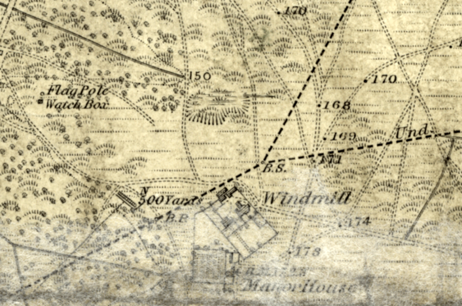
Beyond, a lower lying area with the reservoirs of the Southwark and Vauxhall Water Company. In the distance, across the Thames, the Royal Hospital, Chelsea (left of centre); the Battersea Windmill (centre), Battersea Pumping Station (right of centre); Westminster Abbey and central London (extreme right).
Jon Newman comments:
Pays Bas, the French for 'low country', [is] apt enough but phonetically beyond the locals who pronounced it 'Pay Bar' (a misnomer that made it into print on Stanford's 1862 map).
Pays Bas is also the French name for Holland, which feels equally fitting, seamed as this area was with "curious marshy ditches in which horse leeches were found". The artist Turner, living in Chelsea riverside in the late 1840s, used to refer to the prospect south from his window over Battersea as "my Dutch view".
[8]
"From the top of Wicke's Lane . . . "
From the top of Wicke's-lane you bear in a south-easterly direction across Clapham Common [8] nearly to the corner of the Balham-road, and in a wall which divides the front gardens of two large gentlemen's homes you find a stone, almost hidden with ivy, with the significant initials, "B.P."]
"B.P" — boundary post.

[Check whether the boundary passes down the middle of the lane, or to one side. The latter seems more likely, asince it means Battersea parish has sole responsibility for its upkeep. As a "lane", I suspect it was an important drove road for commoners taking their animals to and from pasture on the Common.]
"The journey across Clapham Common was rather difficult . . . "
The journey across Clapham Common was rather difficult; the old boundary posts have either been removed or perished, but some knowing fellows who accompanied the expedition enabled the parochial officers to decide on those points, where good and substantial marks should be placed. This went down in the book, with the footpath.
[Perhaps significantly, the north-south boundary across Clapham Common is not dead straight, between two or more fixed points at either end, which would have put an end to any confusion. It veers slightly eastward and westward. Why?
[Notice the line more or less divides the Common between Battersea and Clapham. (Just as Wandsworth Common is more or less divided by a south-north-line between Battersea and Wandsworth further round the perambulation. ) Sharing was ...]

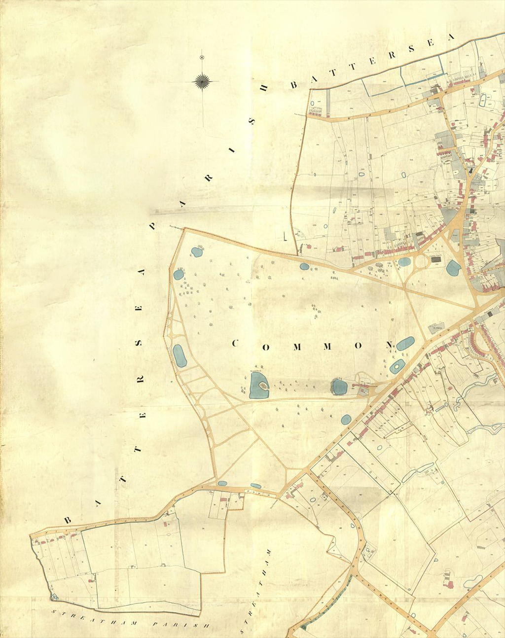
CLAPHAM AND HER COMMONS.
This beautiful open space—the threatened enclosure of which by Lord Spencer has so justly excited the alarm of the inhabitants and neighbourhood—contains two hundred and two acres of land, and lies partly in Clapham parish, and partly in that of Battersea...
There has been a dispute of very ancient standing between the parishes of Clapham and Battersea, respecting this Common; the inhabitants of Battersea claiming about one-half of it as within their parish, whilst the inhabitants of Clapham, on the contrary, assert that the whole common, as far as Batterse-rise, is in the Clapham parish.
In 1711 the inhabitants of Battersea enclosed with a ditch and bank that part of the common which they considered to be within their boundaries; this was resisted by the inhabitants of Clapham, who filled up the ditch and levelled the bank, for which an action of trespass was brought against them by Lord Viscount St. John, the Lord of Manor of Battersea.
The case was heard at the Lent Assizes for October, held at Kingston in 1718, when, after a long trial, Lord St. John suffered a nonsuit.
The inhabitants of Battersea, nevertheless, kept up the claim, and included the disputed ground in the perambulations.
[nonsuit = "stop (a lawsuit or the plaintiff bringing it), either by voluntary withdrawal by the plaintiff, or by a finding by the judge that the plaintiff has failed to make a legal case or bring sufficient evidence." Which was it in this case - did St. John withdraw, fearing he wouldn't win at this time?]
[A non-suit is a legal procedure. A plaintiff (or other person bringing a civil action, such as a petitioner) drops his or her suit, under certain circumstances that do not prevent another action being brought later on the same facts. In the common law courts (e.g. the Court of Common Pleas) a party to a civil action had a right of withdraw their claim/counterclaim by nonsuit up until verdict or judgment without prejudice to the launch of a fresh action.
See e.g. https://en.wikipedia.org/wiki/Non-suit]
This is how puts Simmonds puts it (in All About Battersea), quoting Brayley [follow up]:
The greater part of Wandsworth Common, which extends nearly two miles in length towards Streatham, and a considerable part of Clapham Common are in the Parish of Battersea." The boundaries of Clapham Parish, according to the oldest documents of that Parish and Manor, when taken, have usually commenced at the corner of Wix's Lane, formerly called Browmell's corner. The limits of Clapham Parish where it adjoins Battersea in the early part of last century was the subject of a legal contest, that part of Clapham Common extending to Battersea Rise being claimed by both parishes. In 1716 the inhabitants of Battersea inclosed with a ditch and bank the tract of land in question, and the people of Clapham levelled the bank and filled up the ditch; in consequence of which Henry Lord Viscount St. John, the Lord of the Manor of Battersea, brought an action for trespass against those who were engaged in this work, or their employers, which was tried at the Lent Assizes at Kingston, in 1718, when the plaintiff was non-suited. The men of Battersea however were not discouraged but persevered with greater determination than ever in supporting their claim by including when they beat the boundaries of their Parish the disputed ground in their perambulations; and says Mr. Brayley "it would seem to have been eventually successful, a certain portion of the Common being now held on lease of Earl Spencer as Lord of the Manor of Battersea." — Brayley, Surrey Mantel, Vol. III. p. 281. Brayley wrote, citing Lysons: Clapham parish is bounded, on the north, north-west, and west, by that of Battersea; on the east, by Lambeth; andonthesouth, by Streatham. The limits of the parish where it adjoins Battersea have been the subject of a legal contest, that part of Clapham common extending to Battersea-rise being claimed by both parishes. In 1716, the inhabitants of Battersea inclosed with a ditch and bank the tract of land in question, and the people of Clapham levelled the bank and filled up the ditch; in consequence of which, Henry, lord viscount St. John, then lord of the manor of Battersea, brought an action for trespass against those who were engaged in this work, or their employers; which was tried at the assizes at Kingston, in 1718, when the plaintiff was non-suited. The men of Battersea, however, persevered in supporting their claim, by including the disputed ground in their parochial perambulations; and it would seem to have been eventually successful; a certain portion of the common being now held on lease of Earl Spencer, as lord of the manor of Battersea. [9. Lysons, Environs of London, vol. vi.; Supplement, p. 18.]
Clapham Common.— Until after the middle of the last century, this common, which comprises an area of two hundred and two acres, was an almost impassable marsh; but about the year 1760, through the influence and exertions of Christopher Baldwin, esq., a Surrey magistrate, who had resided many years near the spot, the land was drained, and trees planted of various species, and the roads crossing it were repaired.10 The cost of these improvements was defrayed by a subscription raised among the neighbouring inhabitants; and similar means have been since employed to keep the common in good order. From a falling off of the subscriptions, however, some fifteen or twenty years ago, and a want of due authority, the common was greatly neglected, and much exertion was required of the neighbouring gentry to devise efficient remedies. At length, in the years 1835 and 1836, leases of the manorial rights over the entire common were obtained for twelve years; that part in Clapham parish, at an annual rent of 45/.; and that in Battersea parish, at a rent of 20L During the above and the following years to the end of December, 1838, donations to the amount of 896/. Is. were made for carrying into effect the contemplated improvements; in 1839 and 1840, further sums to the extent of 248/. 6s. were given for the same purpose; and other donations, amounting to 138/., were made in 1844. Subscriptions, amounting on the average to about 150/. per annum, have likewise been received; " by which means the trustees, (to whom the leases had been granted), were enabled to restore the drainage and water-courses; cleanse out the three principal ponds, namely, the Island pond, the Long-boat pond, and the Mount pond; improve the plantations, and, generally, to execute whatever other works were necessary to give the c o m m o n that attractive park-like character
[10. Lysons, Environs, vol.i.p.159: 1792.— In consequence of the improvements thus effected, the value of the surrounding lands was greatly augmented, and Mr. Baldwin himself (a few years before Lysons wrote), sold fourteen acres of land near his own residence for the sum of £5000. In1810, Mr.Robert Thornton sold his land here at the rate of £500 per acre.— Manning and Bray, Surrey, vol.i.p.359.]
11 Much to the honour of Earl Spencer (the lord of Battersea), and Henry Bowyer, esq. (the lord of Clapham), their names are registered in the list of subscribers; the former subscribing £20 annually (the amount of his rent), and the latter £10.10s. The common subscriptions are one and two guineas per annum. [??] and appearance which it now possesses. This extensive tract is nearly surrounded by well-built villas, and other dwellings, the residences of merchants and gentlemen to w h o m its short distance from the busy haunts of the metropolis render it of convenient and easy access. The airy cheerfulness of this spot greatly tends to the salubrity of the neighbourhood. It is, at all times, available for recreation; and being now under the regular superintendence of a keeper, (who acts as constable, also), is free from the nuisances of former times. [Name? clapham-parish-boundary-occasional-sheet-207-april-1965.jpg] To the north and west the Parish of Claphem has always been bounded by Battersea, but precisely where the boundary ran in one particular part was for centuries in dispute, The northern boundary followed 2 Watercourses in Battarsea Fields, now represented by Feath Road, as far as a field known as Little Zelborn and then turned south — across the main road and up “ix"s tans to what in former times was ealled Srowmall's Corner where. the Lane met the roadway along the north side cf the Common. This was where the trouble began, Yhen both Clapham and Battarsea were rursl villagss the inhabitants drove their eatctle and sheep onto the common and then wandered at will without, in all probability, more than occasional argument. But in 1726 the Battersea foik, maintaining that tho grating ¢tc. ras being maonopolised by the men of Clapham, dug a ditch diagonally across to where isa now Clapham South Station ard claimed that the portion to the west was theirs. Indeed in their records they enlled it the East Heath and not Clapham Common at all. The men of Clapham promptly filled in the ditch and desoliahed tha bank and Sir Henry Atkins as Lord of the Manor brought an action for trespass against Battersea in 171é, Batterses produced a document of 1605 faveuring their claim but the evidence was. deemed insufficient and they were nonsuited. A subsequent suit brought ‘in an endeavour to get a definite decision seems to have come to nothing. There the matter treated and as the parishes became less and less agricultural and ag no question of rates was involved, the question was of no great practi¢al importance, but the dispute rankled, and when the parishes Beat the Bounds as they.did et intervale thera were sometimes scuffles. Letters passed between the Lords of the Manor, the Rectors and the Churchwardens but neither sica would give way though at these lavels the dispute became an increasingly amicable one. Early in the nineteenth cantury Ciapham severe] times perembulated the ‘ bounds ard passed along the Teat Side ceusing Yr. deorge Hyde Wollaaten, then one of the Common Eeepers of the Manor ¢f Sattersea, to proteet. It was te who compiled the Kay and Companien to the Plan of Clapham published by the local boukseller Henry Betten in 1627 in which it may be noted there is a tong deserintion of tha Chphan parish boundaries, — but with no wzention of the disputed sectien. . In the Yeatry at Roly Trinity is a book which ccntains 8 description, of the Bounds Beating ceremonial which at Clapham seems to have taken ten hours to complete. The procession was aceded ty the Clergy, on horseback or in a carriags, ottended by the Churchvardens, the Surveyers of the Highways, Orergeer3, Ate Connor, Vestry Clerk, Constables and . Headborough, all «ith white wande and favora in their hate. “hen cane the Beadles with their staffs, tro men vith natchets and saws to clear encroachments, the general body of thea inhabitants and lestiy the boys af the parish with wands and flege conducted by 4 man 4prointed to preserve order. The rear was brought we by « cart bearing boundary poets for renlacenents. At each post the position was proclaimed by the Crier and the company gave three cheers. , ” . Following Wir. ‘Tollaaton's protests Clapham seems not to hare pressed its cinim for sone years but in 1859 the long procession tance again set out and towards the end of the day took its vay sicng “ast Side. One of the houses there ras occupied by Fieid darshal Sir George Pollock, hero of the Afghan Years. He seens to have been avay from hone but when he heard of the day's proceedinze from Lady Pollock he [??] ee considerably annoyed and wrote et once to Mr. Freeman, Churchwarden ‘Of Clapham. "On the 2né June leat a number of people came in a body to the front of my House .- they opened one of the gates, passed through the Ground and went out of the opposite Gate . . . I don't know of whoo all the Hub consisted but I agor thet the loctor of Clapham was there, also one of Ais Curates.” ir, Frespan aaintained he had authority. Tae Field tareshsl denied i+, and ine final volley deslared — ‘Nf on any future cecasion fny versen either as Church Warden or any other aapacity attempts to open my Gates sni walk through sy grounds and cannot produce an authority for such intrusion I shall (if present} rasiet it ms atrespnas"”. But the Bounds were not perambulated again wantil L&T7 and by then Sir George was dead. [Name? clapham-parish-boundary-occasional-sheet-207-april-1965.jpg] [Notice, incidentally, tiny Latchmoor Common, just north of Clapham Common. [Add a link to info about enclosure of Latchmoor Common, its subsequent use as allotments, and the building of the Lammas Hall to compensate. In 1903, the Latchmere Estate was built on part of this site. See e.g. the brief statement in the Survey of London: Battersea "Battersea Park Road to Latchmere Road", also Nicola Hales, "The Latchmere Estate — the Story behind its Street Names", Wandsworth Historian 80.]] [I assume Latchmoor and Battersea East Common (Clapham Common) were once joined by a lane or drove road — possibly Wickes's Lane was once part of this route. From Clapham Common, Battersea commoners could then drive their animals to Battersea West Common (today's Wandsworth Common) via Nightingale Lane or Battersea Rise (or even St John's Hill). Would Battersea-ites have been turfed off the two Garratt Greens though, which they could have accessed via Burntwood Lane?] It is worth reminding ourselves that commons such as Clapham, Wandsworth, and Wimbledon were all divided between adjacent manors and parishes, neither party being able to claim exclusive rights. Or rather, they were shared. In each case, "copyholders" and "commoners" — those with rights to use the resources of the common as a resource (for example, for grazing animals, or to provide firewood, or gravel) — had roughly equal access. [The word is "intercommoning", a practice that was, er, very common. The boundary lines are often (though not always) clearly shown on maps, but these lines demonstrate shared rights as well as separate "ownership", involving distinct rights and responsibilities.] Recall the situation on Wimbledon Common, where many duels took place (including the notorious one between Lord Cardigan and Captain Tuckett in 1841). The duellists fought at the point near the Windmill where Putney, Wimbledon and Wandsworth parishes meet. Why here? Because sight lines were good on the Common's once open grassy terrain, and duellists could only arrested by a beadle (a sort of parish policeman) in his own parish. So if they saw a beadle coming, the duellists could simple step across the boundary line into a neighbouring parish. Did duellists on Wandsworth Common (and there were a number of duels here) cross the Battersea-Wandsworth boundary to avoid arrest? [Stephen Midlane has a photo of the Putney-Wandsworth-Wimbledon boundary stone, I think.]
"Good and substantial marks" were indeed eventually placed along the entire route — see e.g. Parish Boundaries: List of Stones and Marks, 1886 (copy in hand), which I also hope to write about sometime soon. Some of these markers are known to survive, and there may be others (perhaps concealed in gardens) that it would be good to locate.] "The south side of Nightingale Lane . . . " From this point you pass along the front gardens of all the houses on the south side of Nightingale-lane [9]. A row of old pollard oaks forms, in fact, the boundary lines at the road and about half of all the front gardens are in Battersea parish, and the houses in Streatham. [Actually, not (mainly) in Streatham but a "detached" part of Clapham. Notice how much of this section of the Clapham/Streatham border is defined by the "York Sewer" — the Falcon Brook.] Some Boundary Posts along Nightingale Lane . . . Today (12 May 2023) I took some quick snaps of boundary posts on Nightingale Lane. I probably didn't find all, but there were quite a few. It would be wonderful to locate and photograph all of the boundary markers around Battersea parish. Here is a selection: [10] "A respectable white-looking house . . . " At the Wandsworth Common end of Nightingale-lane you see a respectable white-looking house, just painted inside and out [10]. Part of this house is in Battersea parish, and when the army collected in a confused heap before the front door, the servant, in her own expressive language, "wondered what was up." This must be "Nightingale Cottage", seen here on an Ordnance Survey map of 1868: The Churchwarden and Vestry Clerk were admitted, and the boys, who like seeing the inside of strange houses, were rather disappointed. "Twenty-five years ago the present Bishop of Bath and Wells cheerfully underwent the proper bumping at this spot..." The conspicuous white post at the corner was impressed on the memory by the usual bumping, which, at various points, had distinguished the day's proceedings; and it is worthy of remark that twenty-five years ago the present Bishop of Bath and Wells cheerfully underwent the proper bumping at this spot. This must be a mistake, although a strange one. The Bishop of Bath and Wells at this time was Robert Eden, 3rd Baron Auckland, who has no (known) connection with Battersea. So who was it? The reference seems more likely to be to local-boy Samuel Wilberforce (1805-1873), son of the famous William (the MP who led the anti-slave trade movement). Widely known as "Soapy Sam" (thanks to what Disraeli called his "unctuous, oleaginous, saponaceous" manner), he grew up "between the Commons" in Broomfield House (renamed Broomwood House). But 25 years since the bumping is too soon — he would have been too old. Fifty years is perhaps more like it. Possible? But in these degenerate days no clergyman accompanied the parish officers and little boys on this festive occasion, or gave by their presence that friendly counsel which all expect but few receive.
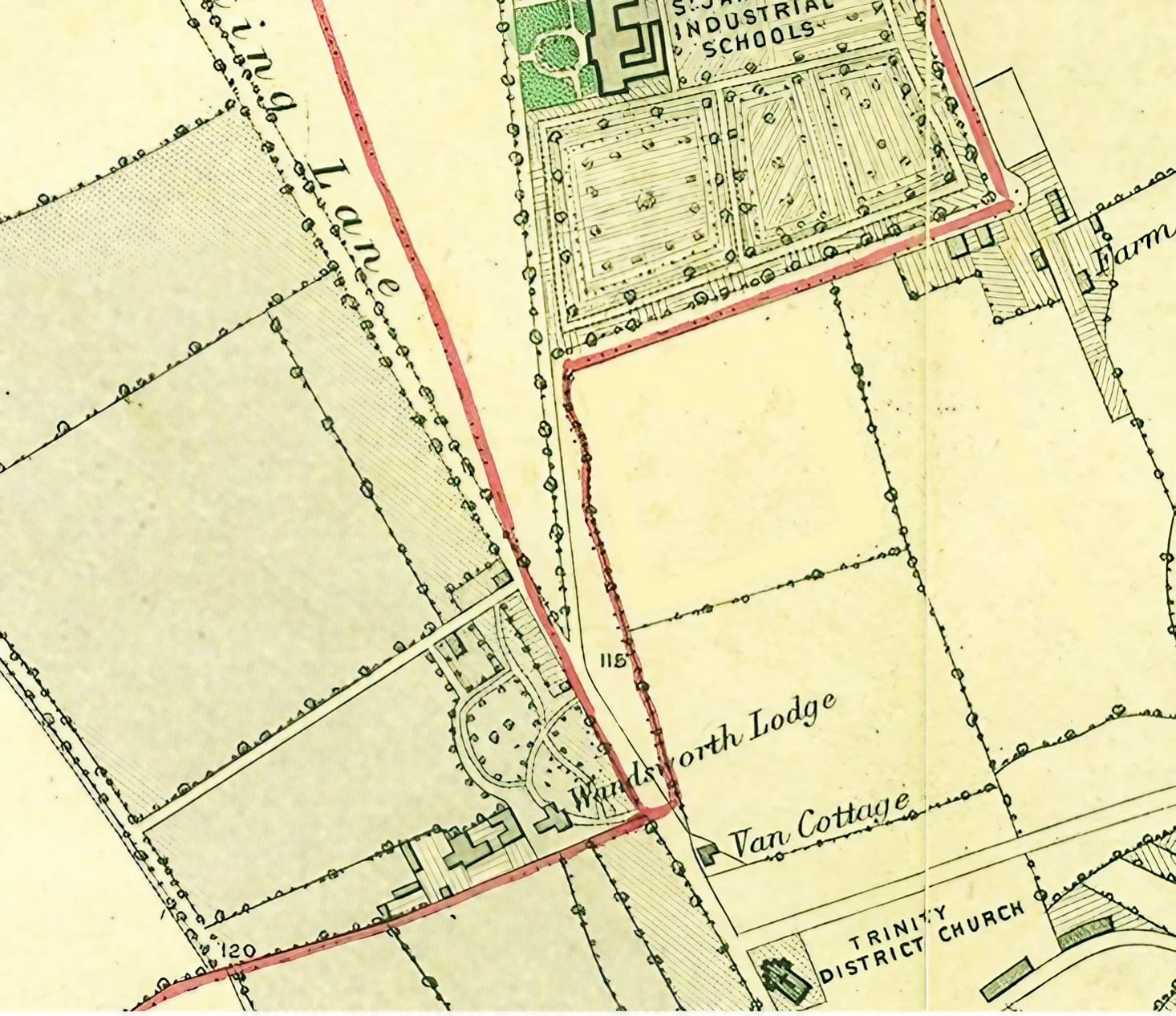
I have already noted the dripping irony above, presumably addressed to the thenvicar of St Mary's, the Revd J.S. Jenkinson. "St. James's Industrial School . . . " From this post the journey proceeds to the south of the St. James's Industrial School [11], and in a delightful green lane, not like the one in Battersea, the boys and men seated themselves on the grass, and were plentifully supplied with cold ham and beef and bread and cheese, with a little wholesome beer. The sale of this large chunk of Wandsworth Common land for the construction of the school was one of a number of Earl Spencer's "charitable" actions around Wandsworth Common. The specific connection here is that (Spencer House), the good Earl's palatial home, was in St James's parish, Westminster — where local pauper children must have been quite nuisance. (He charged the parish £ 600 for its 20 acres.) He also sold common land for the Royal Freemasons' School for Girls, for the Royal Victoria Patriotic School for Girls, and the fields in front of Wandsworth Prison. (Earlier, he had sold land cut from the Common to various railway companies.) Buckmaster was a committed abstentionist — but can we assume that "a little wholesome beer" was such low-alcohol "small beer" that he thought it was acceptable, even for children? Battersea village's "Green Lane" ran just south of the National Society's Teachers Training College (St John's). The green lane (shown on Stanford 1862 as "The Drive") that runs from Nightingale Cottage past a row of large houses, including "Fernside", is not today's Ravenslea Road. This was built later as a projection of Bolingbroke Grove. [NB. Unlike Nightingale Lane (shown inside the Battersea parish boundary) The Drive/Green Lane is represented as wholly inside Streatham parish. So the Battersea boundary is the line of the Common at this point, then comes come the Drive, then the front gardens etc. I came across a letter in which someone who lived in a house on the Drive, possibly Millis Coventry or James Anderson Rose, saying how they live on the edge of the Common, in sight of Battersea, Tooting, Streatham, and Wandsworth, and would happily pay rates to fund it, but don't have any say over the future of the Common (presumably because they live just inside Streatham parish).] At this time the lane (and boundary) continued over the new railway line to run along outside/behind the St James's Industrial School [on a more or less rectangular plot carved from the Common in the early 1850s. This was the great event of the day; how the little fellows did eat! it really gives a good-natured man a great deal of pleasure to see such a sight. The Churchwarden was laughing and saying good-natured things to the boys, and telling them to eat away. But how rapidly the party increases at such a time. Suddenly you find great numbers of persons ready to join in the eating. Where do they come from? Surely a common cannot produce them? but there they are all declaring most solemnly they had been with the party all day, although it is the first time you ever saw them. The rural dinner over, the churchwarden's health was drank in good spirit. This was not the time or the audience for speechifying, so Mr. Walton just thanked them for their kindness, and the party then proceeded just to the side of Mr. McKellar's front gate [12] "McKellar's front gate" — the entrance to Wandsworth Lodge. This is the southernmost point of the perambulation, and what was then still thought of by many as the furthest extent of Wandsworth Common. Henry McKellar (or M'Kellar) lived in Wandsworth Lodge. In spite of its name, it was not the entrance to a larger house behind but a very considerable house in its own right — perhaps the largest of any house round the Common — with substantial grounds and many greenhouses etc. Like so many rich villa-owners in the area, McKellar had a passion for horticulture, for which he (or his gardeners) won prizes. There may have been some animus behind this report because McKellar had recently bought a large part of Wandsworth Common from Earl Spencer. The great wedge between Trinity Road, St James's Drive, and Bellevue was often referred to in the campaign to save the Common as "McKellar's Triangle".
"Here they sung "God save the Queen, " and then proceeded across the common . . . " [14] Here they sung "God save the Queen, " and then proceeded across the common [13], to about two hundred yards below the Clapham Common station [14]; here they crossed the line, and continued along the black fence into the road . . .
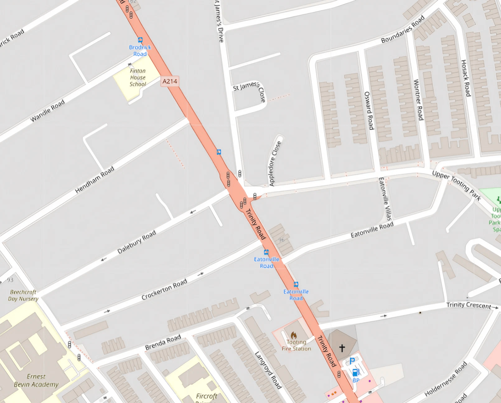
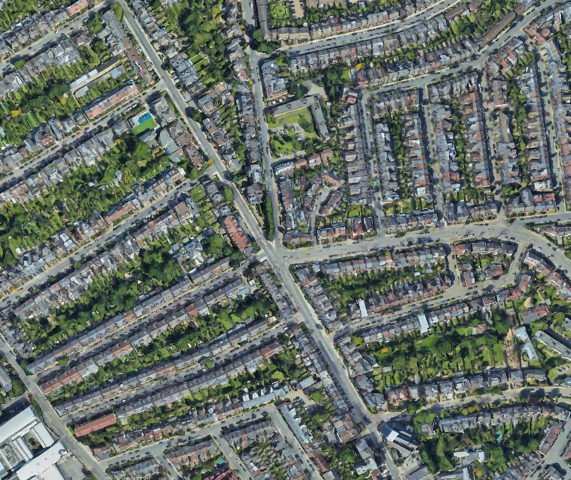
Perambulators then (and now) must find the immense journey southward to the corner of St james's Drive and Trinity Road really bizarre. Surely this can't still be Battersea? And why does the boundary turn back on itself so sharply, like a handbrake turn in a sports car? And the "sting"? Why is there a strip of Battersea only two or thirty yards wide [?] projecting almost as far as Holy Trinity church (Streatham parish)?
It really is a puzzle. The local archaeologist Nick Fuentes and historian Keith Bailey suggested in might be because the Anglo-Saxons used ancient burial mounds — possibly Iron Age barrows — as a turning point. Interestingly the barrows are sited very close to but not on the highest point on the Wandsworth Common Massif, which is about fifty yards away to the west near Dalebury Road. This is not fatal to the theory — on the contrary, most Iron Age burials were positioned below summits or crests in such a posotion that their silhouette would be visible against the sky. Keith Bailey argues that, provided the mounds were at least 10? feet high, a viewer could stand on the top and see down into the Wandle Valley below. If the next turning point on the early long boundary marking Battersea-cum-Wandsworth was in that direction, it would be visible. (In KB's view, "Blacan Mor" is likely to be a peat-covered (hence "black") moor between this point and the Wandle ["Noisy Stream"?] below. [Blacan Mor — black because of burnt furze — swaled.] If it is accepted that Battersea-cum-Wandsworth was subsequently divided, the munds again would be the best turning point. (Battersea — the senior partner — is likely to have claimed the whole of the sacred burial mounds as their own.) Hence the handbrake turn around burial mounds, and the creation of the "sting". Nothing is said in the 1862 account, but it seems likely that the perambulators were still able to walk uninterrupted in a straight line across McKellar's Triangle to Bellevue Road, then on to the edge of what is now the "Toast Rack" (largely nurseries a this time), directly across the grounds of the Royal Victoria Patriotic Asylum for Girls to the railway line near "Clapham Common Station". (The boys' school — now Emanuel — was built on a little used part of the girls' grounds in 1872.) [Mid-C19] maps show numerous boundary posts from the corner right the way through "McKellar's Triangle", to the Common, and then right the eay through to today's Spencer Park. Presumably each post could be seen from one to the next. When McKellar's Triangle was built upon, many of these posts were in the gardens, or on streets (where the streets such as Brodrick and Nottingham crossed the line. The line appeared again on Bellevue (it passed through White Lodge, fairly recently rebuilt). Are there any posts remaining in these gardens? [I found this rather lovely photo online somewhere. It would be good to use a locally-sourced image.] [Notes I put together for the 5 May 2024 perambulation. The walkers met at the Boundary Oak. We're gathering together today by what we call the Boundary Oak — it was Stephen Midlane who first pointed this out to me. Once seen (and touched), never forgotten — which was what perambulations are all about. Impress a memory of this tree on your grandchildren and in 70 or 80 years time, at the end of this century (all being well) they will be pointing it out to their grandchildren. And so on... The time line stretches back to "time immemorial" [and forward to "time inconceivable"?] In truth, we're not absolutely certain that it was planted for that purpose, or exactly when, but it might well have been. But it's certainly on the line, and that's what counts. [We know from an C18 will that a man left money for an oak to be planted on the Streatham/Battersea border — just over there, on the other side of Wandsworth Common Station — this was in the mid-1700s. [Add details]] Why an oak? Well they're good old English trees, easily identified, and they last a very long time. [Gospel Oak in North London refers to one. Angus Winchester, Discovering Parish Boundaries, p.41, refers to the importance of The Vicar's Oak in settling a dispute between Croydon and Penge (then an exclave of Battersea).] But when it was an uninterrupted Common.... "About two hundred yards below the Clapham Common station . . . they crossed the line . . . " [This suggests the perambulators crossed the RVPA Girls grounds, then crossed the railway line, before turning left along what is now called North Side. The girls' orphanage opened in 1859, but the boys' school was not built until 1872 — it was sold to Emanuel School in 1881, and the first boys arrived in 1883. [15] "The wall dividing the Union from the Fishmongers Almshouses . . . " . . . and from there to the west side of the Union workhouse [15]. The wall dividing the Union from the Fishmongers Almshouses forms part of the western boundary of the parish.
The Parish Boundary.
(Click on image to enlarge)
Tithe maps from c.1840 for Battersea and Clapham — both claiming the western side of Clapham Common for their respective parishes. I had assumed that the early OS 1-inch maps and the tithe maps put an end to such boundary disputes. Clearly not.
Stanford, 1861
[NB The argument that the Common was bisected by the boundary, with roughly equal areas of Common on either side, is even more compelling if you recall that many areas shown here as private parks, nurseries, or charitable institutions had been part of the Common only a few years before — e.g. The Royal Victoria Patriotic Asylum for Girls, Spencer Park, the land in front of the prison (now called the "Prison Banks") and Burntwood House, the Observatory area (taken out of the "Scope"), St James's Industrial School, and the land acquired by Henry McKellar ("McKellar's Triangle" and the area across to the Surrey Lunatic Asylum, shown here partly as enclosed fields).
(Click on image to enlarge)
![]()

The Battersea boundary is on the south side of Nightingale Lane, abutting a detached part of Clapham parish.
(Click on image to enlarge)

On Clapham Common, near Clapham South tube station.

Under the hedge, in front of [Clapham Mansions?]

[Nearby]

North side of Alderbrook Road.

The other side of Alderbrook Road.

Outside no.67 — the corner of Ramsden Road.
(Photos: PB.)
(Click on images to enlarge)
![]()


Nightingale Lane — Nightingale Cottage — the "green lane" to Fernside and beyond. Although Fernside and neighbouring houses are on the very edge of Wandsworth Common, the houses (and Drive) are in Streatham (not Battersea) parish.
Wandsworth Common Station opened nearby in 1869.
(Click on image to enlarge)
![]()
![]()

Samuel Wilberforce, Bishop of Oxford, by Ape, Vanity Fair, 24 July 1869.
![]()
![]()

St James's Industrial School (photo of unknown date), built 1851— 2 for pauper children of St James's parish in central London. It gave its name to St James's Road (now Drive).
(Click on image to enlarge)

The passage into the Common from Balham Park Road — all that remains of the "delightful green lane" (cut in two by the railway) that ran from Nightingale Cottage past Fernside.
Notice the small Battersea boundary post at its entrance.
(Click on image to enlarge)
![]()


Wandsworth and Battersea boundary posts opposite the site of Henry McKellar's Wandsworth Lodge. (Photos: PB.)
.
(Click on image to enlarge)

By 1868, "McKellar's Triangle" (tinted pink here), and other land he had bought from Earl Spencer, was being rapidly covered with new roads and houses. "There was still nothing but empty fields here in 1863 when McKellar died and this land was sold along with rest of his estate." (Survey of London: Battersea, vol 50, ch.19 — an excellent account of the building history of Battersea's "Deep South").
(Click on image to enlarge)
![]()
Battersea's sting in the tail

This ancient little sting in the tail of the Battersea bee is one of the great enigmas in the history of the area — with manifold effects on the subsequent layout of roads and houses. Battersea, Wandsworth and Streatham parishes meet here, at the corner of "Mr McKellar's front gate" [Wandsworth Lodge].
(Click on image to enlarge)

Nick-Fuentes-map-of-burial-mounds-and-boundary-across-blacan-mor-1024px.jpg
(Click on image to enlarge)

Today's zig-zag route from the southernmost corner where Trinity Road and St James's Drive diverge...
"The Boundary Tree"
Why a straight line?It isn't a straight line now, because it has to take into account all the roads that have been built, and new buildings....
Crossing the common
The traditional Wandsworth— Battersea boundary is crossed in a number of places behind today's "Toast Rack" — there are probably more boundary markers in this area than anywhere else around the parish. This reflects a complex history in which, many centuries ago, Allfarthing Manor was given a small foothold on the Common — the "Allfarthing Piece" (on which more another time).
(Click on image to enlarge)

Local boundary-post-hunter at work. Marlowe finds one in the passage between the Common and Routh/Baskerville Road.


"Clapham Common" station (opened 1838, closed 1863), with the Royal Freemasons' School for Girls in the background.
The house, park and "Black Sea" shown bottom left in the angle of the red boundary line was leased to the Wilson family, who owned Price's Candle Works. Their Belmont factory was sited where the Falcon Brook entered the Thames.
(Click on image to enlarge)

OS 1895, showing the original Battersea-Wandsworth boundary running through the Emanuel School grounds. Emanuel is (almost) entirely in Battersea. The girls' school (almost) entirely within Wandsworth.
(Click on image to enlarge)

Why did/does the long (straight? sightly curved?) boundary across the Common suddenly turn east (along North Side), than north-ish (Spanish Road), then north-east (York Road) than north-west? If the straight/slightly curved boundary line had continued, it would have reached the Thames at the mouth of the Falconbrook. Is this relevant?
(Click on image to enlarge)
![]()

A gorgeous engraving of St Peter's Hospital, also known as the Fishmongers' Almshouses, on East Hill (1849). The original was by Thomas Shotter Boys (1803— 1874) — my namesake, but sadly no relation (that I know of).
The gateway can still be seen today, though altered by the London County Council when they knocked St Peter's down and built the East Hill Estate (1923 — this was itself knocked down and rebuilt in 1982.
The heavily wooded area to the right may be artistic licence — invented to conceal the Workhouse next door. The wall between them formed the boundary between Battersea and Wandsworth (so the Workhouse was in Battersea).
[16]
Continuing this line across the Richmond Railway [16], into the Wandsworth-road, and from there down a lane on the east side of the Distillery [17] to the Thames, into Battersea-square [1], forms a general descriptive outline of the home bounds of the parish of Battersea.
"After about eight hours the party arrived at the spot from which they started. . . .
The day was everything that could be wished, and there was no disagreeableness during the whole time.
After about eight hours the party arrived at the spot from which they started. Mrs. Walton provided cake and tea for a number of the boys in the evening. Among the party we noticed Mr. Perry, the churchwarden of St. George's, the school-master, Messrs. Poupart, Juer, W. Griffin, Buckmaster, and others.

"Eight hours . . . "
If we were to try to walk the same course today, I wonder how long it would take? How close could we get to the original boundary? How much has the boundary been modified? Have more enclosures taken place?
That's it for the perambulation of Battersea parish, 1862. But just for fun I've tacked on a coda about beating the bounds of a Battersea school in the 1920s...

The Open Space Society: Village Green: Beating the bounds of your local common or green
Beating the bounds is typically associated with churches and parishes, but any area can be perambulated — a school, farm, manor, borough or indeed a common, such as Wandsworth's.
Click here to read a ‘how-to-do-it’ article, Village Green: Beating the Bounds of your local common or green (or download a pdf) produced by the Open Space Society. (The Open Space Society was first known as the Commons Preservation Society (founded 1865) — they were very active in the campaign to save Wandsworth Common.)
Many thanks to Stephen Midlane for this reference and link — he tells me he's rather looking forward to one day seeing "a theatrical procession complete with willow wands, costumes, music, and singing" crossing the Common.
Hear! Hear!
— Parish boundary markers and perambulations (pdf)
Battersea parish divided . . .
The parish of St Mary is much smaller today than in 1862 because several new churches and parishes have been created.
Here are two maps from the St Mary's website:


[The first new parish in Battersea was St George's, Nine Elms (1831 — the church opened in 1828. See NineElmsLondon.com: Boozers, Bombs and Bodies: the forgotten church of Nine Elms (The article was researched and written by The Battersea Society.)
Christ Church, off Battersea Park Road, was another new church and parish. Although it was consecrated in 1849, it not have its own parish until 1861. As it happens, my great-grandparents were married here in 1866, only a few years after the perambulation took place. What brought them to Battersea (from rural Sussex)? I have no idea.
Daughter churches/parishes near Wandsworth Common include St Mark's (consecrated 1872), St Michael's (1883), and St Luke's (1892). On this and much else, see The Survey of London: Battersea — a marvellous resource.]
Parish boundaries form an invisible lace network that connects the whole country.
I always tended to think of the "parish" in wholly religious terms, and that certainly was important — your parish, and your parish church and graveyard, your parish priest — where you looked in spiritual matters. You would probably attend your parish church on Sundays, Saints' Days and other, almost innumerable celebrations throughout the year — you're likely to have been baptised, married, and buried in your parish church. You paid tithes in your parish. For hundreds of years records were kept in parish chests of these events.
But your parish also always had civil or secular functions — it was concerned with education, charity and poor relief, taxes and rates [and much else].
During the C19 the two aspects — religious and civil — separated. We're here today tracing the route of the civil parish of Battersea. This follows the boundary (more or less) of the ecclesiastical parish of St Mary's Battersea as it was in the early C19. And for a long time before that. Its shape and size is probably pretty much as it was 800 years ago. Perhaps many centuries more than that.
There's an argument that much of the route you're walking today follows boundaries established in Anglo-Saxon times (which is when the parish system was set up, partly based on Roman antecedents). Indeed some sections of today's parish boundaries may date from the Iron Age (i.e. c.800 BC to AD43).
Weird, eh?
The church (and its "vestry") was one of the main places for local government, administration and political life — parishioners came together to decide on repairs to roads, the creation and mending of bridges, the provision of water and much else...
But during the C19 rapid population growth meant that one church wasn't enough and now the parish has been subdivided.
Battersea now has 10 ecclesiastical parishes, all subdivisions of the earlier St Mary's (If you started at St Mary's you walked first into Battersea Fields, then Battersea St Philip, Lavender Hill The Ascension, Clapham Common St Barnabas, Battersea St Luke. In a short while you'll enter Wandsworth Common St Michael, Battersea Rise St Martk, Battersea St Peter and St Paul. The only parish you won't have set foot in is Battersea Christ Church.]
But there's only one Civil Parish. And everyone, regardless of their religion, lives in a particular civil parish.
There are now more than 10, 000 civil parishes.
— Wikipedia: Civil parish
Beating the Bounds of Emanuel School, 1920s


[* Old Emanuel Wilfred Scott-Giles (1893— 1982) — an expert on heraldry who served as Fitzalan Pursuivant Extraordinary — is also almost certainly the person ultimately responsible for the rather strange naming of the Fitzhugh Estate, built on what had been part of Wandsworth Common. There's Fitzhugh itself, but also its five eleven-story "point-blocks": Gernigan, Morville, Skipsea, St Quentin, and Woodhall — an oddly medievalist turn for mid-twentieth-century modernist tower blocks. If you want to know more, let me know.]

Back to the top of this page . . .
History of Wandsworth Common — Home page and Chronicles.
Send me an email if you want to comment on anything you've seen or read on the site, or would like to know more about something, or just want to be kept in touch.
Philip Boys (aka "HistoryBoys")