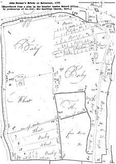
John Baron’s Estate at Battersea, 1775
Build 7 — 27 September 2026
Lost Houses of Wandsworth Common Project
[X: This section looks to / In this section, we ] give a broader sense of the natural landscape surrounding the Five Houses, and draw on other large local properties and their gardens.
[The following excerpt from a well-acknowledged source*] is this * The Survey of London mentioned above? encapsulates the changes that took place to the local landscape of Wandsworth Common between the mid 18c 18th century and the early 20c 20th century:
“Cushioned between wide open spaces, far from the council estates and railways that crowd the north of the parish, this area is today best known for its gridded streets of Victorian and Edwardian housing, built up from the 1850s, constituting Battersea’s latter-day middle-class heartland . . . For 100 years before, this was a very different kind of district: a verdant, genteel suburb of large private villas, wooded grounds and farmland, through which ran the watercourse called the Falcon Brook, on the route of present-day Northcote Road. It is with this lost elysium that . . .” [that what?]
[* Thom, Colin (ed.), Survey of London, Volume 50: Battersea, Part 2—Houses and Housing. London and New Haven: Yale University Press, 2013, p. xx.]
This section looks to give a broader sense of the natural landscape surrounding the Five Houses and draws on other large local properties and their gardens. It covers changes that took place to the local landscape of Wandsworth Common between the mid-18th century and the early 20th century.
[We should probably say more about what the Common looked like in the 1770s-1870s - i.e. from the time the Five Houses were built to the saving of the Common in 1871, or perhaps further on still, to the time the LCC took over in 1889, or to WWI.]
Note to self: In 1763 Frederick St John (= 2nd Viscount Bolingbroke and 3rd Viscount St John), sold the manor of Battersea and Wandsworth to his wife’s cousin, John Spencer, Viscount Spencer, who became 1st Earl Spencer in 1765. > Earl Spencer (1765) → Conservators (1871) → MBW (1887) → LCC (1889) → GLC (1965) → Wandsworth Council (1970s/1980s).]
Land use and type
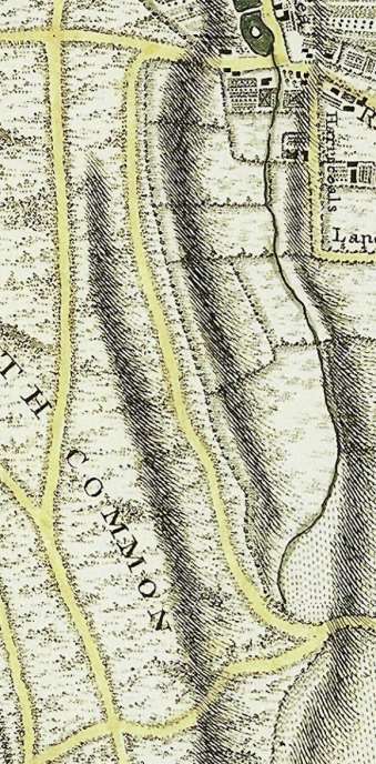
When the Five Houses were built in 1777 the landscape was rural and open having been agricultural - arable, pasture and meadow as shown by John Rocque's maps [of dates?]. Within this verdant green environment, the Five Houses were created foreshadowing Victorian ribbon development [ribbon?] in the mid- late 19c [later in the century]. [John Rocque's] This map of 1761 (below) shows fields all around and undulating ground lying in parallel to east and west of the lane which was initially to become Five Houses Lane.
John Rocque's map [This map] of 1761 shows fields all around and undulating ground lying in parallel to east and west of the lane which was initially to become Five Houses Lane.
The fall of ground from this lane down to the Falcon Brook (now under Northcote Road) to the east gave the Five Houses an elevated position and an outlook to the east that remains a topographic feature today. Bolingbroke Farm is shown in the northeast corner and approached by a main route (now Battersea Rise). The eastern road parallel to Bolingbroke Grove is now a ghost road. The area to become Wandsworth Common is shown as rough land known to be poor, with gravel areas and prone to flooding.
In 1719 Kings Farm (later Bolingbroke Farm), owned by Thomas and John King, was probably a 100-acre holding shown by the 1775 Harman map and an isolated farm complex with few other buildings around. It is shown as growing crops of barley, wheat and potatoes in strips.
Tenants were typically farmers, yeomen, gardeners and labourers.
John Baron’s Estate at Battersea, 1775
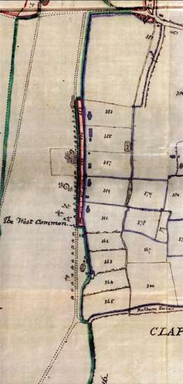
The 1787 Corris map (below) of Wandsworth shows open fields divided into shots or furlongs which were units of cultivation, themselves divided into strips (as can be seen in the Harman map). [Shots referred to have names like] Their names - Gravel shot, Middle shot, South meadow shot, Long shot - [giving an indication of] [are a clear guide to the size, position, soil type and use].
There were few enclosures in 1787 on East Common (now part of Wandsworth Common) compared to Wandsworth West Common (now part of Wimbledon Common).
[Awkward: Going back to the early 17th century and up to the early 19th century, the wider area including Battersea,] had an unusually large proportion of land and employment given over to market gardens, providing cash crops such as fruit, vegetables and flowers to London markets. The rising land values meant many market gardens gave way to ribbon development along roads. Despite the increase in building development in general, there were far fewer large houses in the Battersea parish at this time compared with Clapham, Putney and Roehampton. Within 50 years, though, the population would increase from 4,000 to 120,000.
Thomas Milne's map of 1800 shows land marked as “P”, meaning “Paddocks and Little Parks” – this is true for Bolingbroke Farm and Dent’s Farm which, interestingly, is not described as “A” (“Arable”) or “M” (“Meadow and pasture”_.
[ADD MILNE MAP]
The area marked Wandsworth Common remains rough land with tracks running through, so reminiscent of the Rocque map of 1761. Three of these tracks relate to [will later be translated into] the modern-day Bolingbroke Grove, Bellevue Road and Trinity Road. It is interesting to note that this swathe of land is described as Wandsworth Common to the north and west and Battersea Common to the south and east [, reflecting the respective parishes that...].
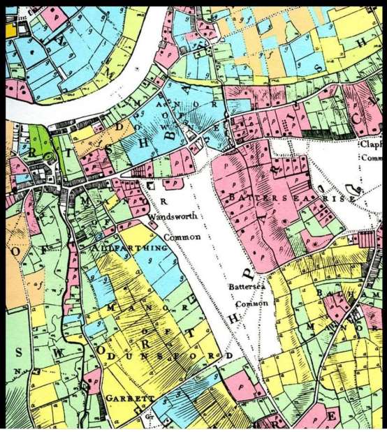
This once-agricultural area is shown in the Tithe map of [1840?] as a mix of arable land, pasture and meadow and the emergence of pleasure grounds and gardens. This map also shows the widening of the Falcon Brook to make ponds or lakes which was characteristic of Capability Brown's style. It also clearly shows the appearance of formalized routes for carriages and transport.
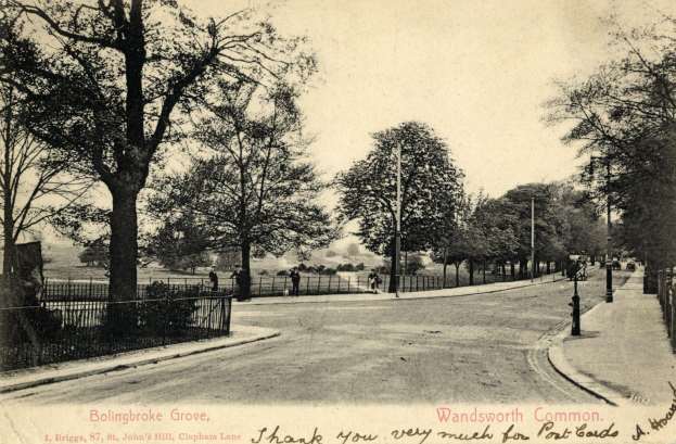
The apportionment book supporting the Tithe map describes land in different terms. For example, we have been unable to clarify the meaning of Upper Bramlands, an area north of Battersea Rise. The name may refer to an individual, or "bram" may mean brambles or gorse so perhaps – as we know gorse was prevalent in the area – it referred to a type of vegetation.
Another [?anomaly ]is “Long Shot”. We do know that a “shot” could refer to a strip of land so it may describe the long rectangular shape of the area.
The reference to Flood Marsh is self-explanatory in confirming the damp conditions, [awkrad: and/although it is clear that some parts of the wider Wandsworth Common area were prone to this more than others.]
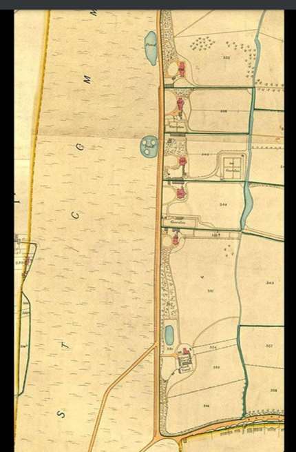
The image below, although taken later than the period referred to here (c.1914), shows a view of Wandsworth Common with established trees and large dark shrubs in the distance which could have been gorse or similar.
A decade after the Tithe Map, the Morning Herald 1853 describes Bolingbroke Grove House as having “riding horses, looseboxes for hunters”. While the royal parks had long disallowed hunting, hunting in the Surrey Hills and on the North Downs of Kent would have been accessible from here. Beyond the ubiquitous carriage horses, there is mention of riding horses. Would they have taken gentle hacks on the Common opposite or local open spaces such as Clapham and Tooting Commons, newly created Battersea Park (formerly Battersea Fields) or beyond to Wimbledon and Richmond?
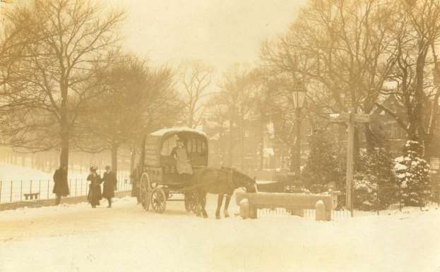
It is also clear that all the significant houses or estates had [pasture and] stables for horses, if not for sporting pursuits but at least for [transport / functional transport purposes], as the image below shows.
City development
[WORK NEEDED - BUT POSSIBLY ALREADY DONE BY HENRIETTA.]
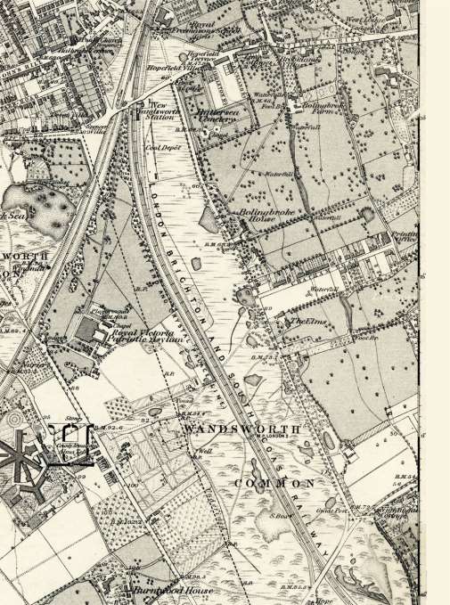
[H: The [1865–73? 1868?] OS map shows an increased-sized pond almost opposite this house and more trees formally planted along the Common edge and sufficient on the residential edge to form the beginnings of what looks like a grove. Also worth noting are the references to ‘waterfall’ in 3 nearby places which explains the damming method of creating long thin lakes from the Falconbrook, a
It is also interesting in its depiction of four recent arrivals for the time but which still exist today. Just beyond the London Brighton and South Coast Railway running parallel to Bolingbroke Grove, lies the Royal Victoria Patriotic Asylum (now Building), the Surrey House of Correction (now Wandsworth Prison), a large plant nursery (now Capital Gardens/Neal’s Nurseries), and the County Arms (name unchanged). The large Battersea Cemetery is shown (its land having been acquired [IN?] from part of the Bolingbroke House estate). The Bolingbroke Estate by Chatham Road is shown and is a prime example of a local prominent house (Bolingbroke Grove House) being demolished to make way for ribbon development [?] of an assortment of terraced, semi-detached, and detached properties with a scattering of pubs and shops. We can see Nightingale Cottage to the south and further housing appearing around St John’s Hill and Spencer Park. This map also shows an emerging network of major roads contouring the Common with major and minor roads running off these main arteries. By 1852 St James Industrial School was established just south of Wandsworth Common.
[Royal Masonic for Girls]
[TIDY UP The area was becoming more developed. However, the three farms of the area - mdash;mdash; Bolingbroke, Dent’s and Old Park - mdash;mdash; remained, so in some areas the existing land use largely prevailed.]
[H: An additional point of interest from the above property sales ad is the mention of the ‘lodge and gates of entrance’. There are other references to these features in sales ads for other of the Five Houses. We have evidence of a ‘green lane’ running from Battersea Rise (where Webbs Rd is now) parallel to the frontage of The Five Houses. The conclusion drawn is that the lodge was ‘Australia Lodge’ complete with gates protecting the lane and its access to the houses. It seems reasonable to assume that this functional access route would have facilitated the movement of goods such as hay and other produce as the 1853 ad also refers to ‘rich Paddocks of Meadow Land’. There must have been either bridges or fording points to cross the Falconbrook.
The census records show during mid 19c the following staff descriptions which indicates the : 1861 - garden servant for Bolingbroke Grove House For the scale of property we can assume maintenance of the extensive grounds was carried out by labour living both in these houses or elsewhere.
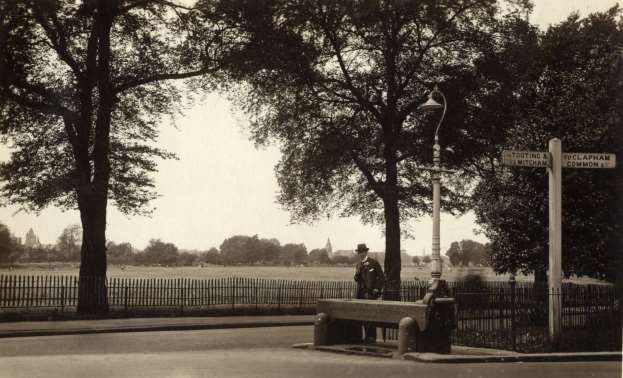
[Awkward: The image below ([DATE? c.1900]) shows the silhouettes of the Royal Victoria Patriotic Building to the far left and St Mark’s Church in the centre. We can see established street furniture and the vestiges of a stone animal trough from the past.]
[Nearby houses]
he 1868 OS map clearly shows the Five Houses were connected by tracks and paths with other properties. The Willis family of Bolingbroke House also owned Bolingbroke Farm. The Dent Family built Old Park House with a farm adjacent (off current Nightingale Lane) and owned Dent’s House and farm (off current Bolingbroke Grove). [Notice also connections with "Broomwood House" (previously known as Broomfield and Broomwood Park) across the Falcon Brook.]
[H: We can see again from the 1865–73? 1868 ? OS map, tracks linking all these properties and estates and also to Broomwood House (also known as Broomfield and Broomwood Park).]
[We know Broomfield was built by 1795 and recreational walks in its 19-acre grounds were recorded. William Wilberforce lived there, but in 1807 he described the environs to a correspondent as a “poor mimicry of the real (live) country”. This comment reflects an opinion that while these estates were impressive, they were often viewed as inferior to the grander, more sophisticated properties north of the river. Between 1834–51 the renowned landscape architect J.B. Papworth was commissioned to make improvements to the gardens. Thornton acquired part of the Broomwood property to shield the grounds of his home Battersea Rise from speculative development in the 1880s. Prior to this, John Deacon purchased Broomwood House when he acquired The Elms (one of the Five Houses) after which Sir Charles Forbes later became the owner of both houses.]
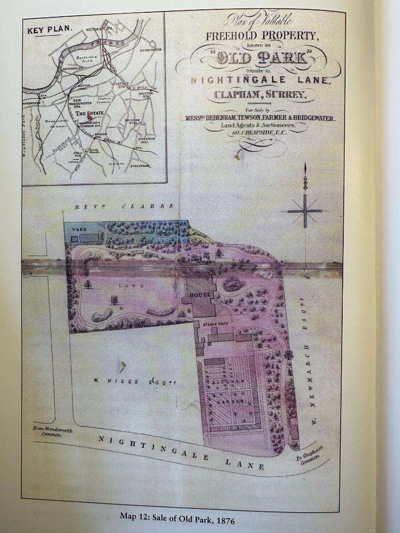
Old Park House was described as “picturesquely situated on an eminence, set within well-wooded grounds at a remove from the main road” (Nightingale Lane) . . . Generous outbuildings included a kitchen yard, coach-houses and three stables as well as a lodge and “cottage” (possibly the farmhouse)”.
[H: Generous outbuildings included a kitchen yard, coach-houses and three stables as well as a lodge and “cottage” (possibly farmhouse?). [quotation marks – the closing quote here doesn't have a matching open after the ellipsis above; worth checking the source?]
[PB: check quote. Is it an advert - mdash;mdash; if so, use a pic.] Dent was typical of many landowners here, also having a town mansion but wanting to establish a country house estate. It was also recorded as having, in addition to garden walls and gates, an obelisk and a ha-ha.
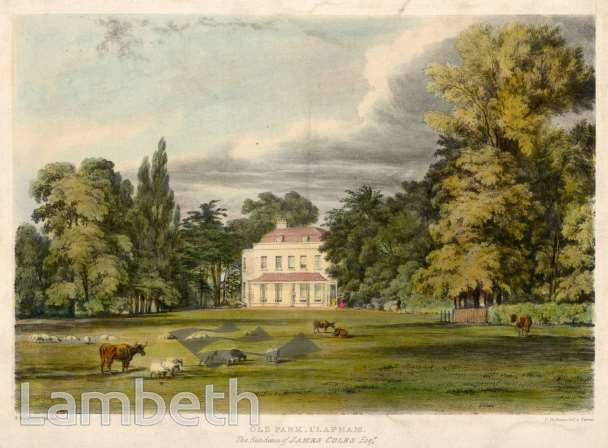
The image below reveals how well-appointed the gardens and private landscape were surrounding the property.
Old Park, Clapham
Although not linked to the Five Houses, Burntwood Grange and House bordering the western side of Wandsworth Common benefited from a typical range of garden characteristics of the time and area. It is worth noting the detail of this property to enhance our understanding of what existed in the 18th and 19th centuries.
Bohn's “Pictorial Handbook of London” of 1854, [based on Edward Kemp?], provides us with a comprehensive picture. It shows evidence that at Burntwood Grange a dairy and kitchen garden existed and were the resources which provided the household with food supplies along with fruit and vegetables. There was also evidence of a “stove” providing the right climate for tender plants like orchids.
Lawns surrounded by evergreen shrubs and fine specimens of Andromeda Floribunda and Deodar Cedar are described alongside a kitchen garden with first-rate forcing houses and pits. Other details include “between the path and walls there is a narrow border, covered with Lycopodiums, Heliotropes, and various low-growing plants, which make a neat fringe to the whole.”
Burntwood Cottage is described in a property sales advert in 1826 as having views of Surrey Hills and Epsom Downs. Before this, in 1813, another described it as “a singularly romantic freehold cottage… embosomed in a plantation of forest trees and shrubs of the choicest kinds … with views in every direction singularly luxuriant and picturesque”.
[This account is [flowery in its language? is there a better phrase?], but you can still get a view of these hills and downs from Lyford Road and Burntwood Lane. The description here helps to reinforce the fact that in the 19th century, the aspect of Wandsworth Common was entirely countrified to the south.
General planting – Trees
Bohn’s Pictorial Handbook of 1854 [same source as above – add the full title here too, for consistency?], based on E. Kemp, notes the local South West London vernacular: “display the most charming diversity of flora and trees, Cedars of Lebanon, of great age and size, constitute a peculiar and very observable feature in the landscape . . . numerous on the west and south-west sides. As adjuncts to stately mansions or elegant villas, alongside the valley of the Thames, they are remarkably telling; and the traveller can scarcely pass a hundred yards . . . Without coming upon fresh specimens or groups of them. It is scarcely necessary to add that they communicate a very marked and aristocratic character to the district”.
Bohn also mentions Deodar Cedar and Spanish Chestnut as being popular.
This excerpt shows how in west and southwest London exotic non-native trees were long-established and valued for their association with foreign cultures and Britain’s excellence in global plant-hunting.
It is worth noting that trees such as elm, white or black poplar, lime, horse chestnut were recorded in the local area of Wandsworth Common, and all flourish on the Common today. [? The soil type and damp characteristics may have changed very slightly over the last 200 years but will have been the same as present.] It is thought that the “grove” was probably created by elm trees, which may explain why one of the Five Houses was called “The Elms”. As early as the 1787 Corris map, Five Houses Lane is edged with trees on the Common side – an indication of the formal enhancement of the area.
Landscape and garden design styles in the 18th and 19th centuries
[WAIT FOR HENRIETTA'S REWRITE.]
Lancelot "Capability" Brown (1716-1783) was the pre-eminent landscaper of the 18th century and his style of undulating parkland punctuated by clumps of trees [rather than rows] and lakes replaced formal gardens [typical of the C17 century..
From the mid-18th century, there began the fashion of parterres [meaning?] inspired by 17th-century France.[BP: I'm a bit confused by this. Would a praphrase of something like this help? " . . .formal, geometric garden design. It consists of planting beds arranged in intricate, symmetrical patterns—often filled with low-growing flowers or herbs—and edged with tightly clipped hedges (usually boxwood) or stone. The paths between the beds are typically made of gravel. They are designed to be looked down upon from a terrace or an upper window of a house.] These large houses probably had space devoted to this formality of bedding plants, box hedging and conifers. The pure Brown landscape had sweeping lawns enveloping the house. The Five Houses and other local prominent properties were likely to have had a blank canvas on which to impose a modest form of the landscape movement. The Falcon Brook was dammed to create ponds typical of Brown’s style. His influence was so deep and widespread that Walpole is known to have said of him “We have discovered the point of perfection. We have given the true model of gardening to the world”.
[Brown: famous for creating the quintessential English landscape garden style, characterized by sweeping lawns, naturalistic lakes, clumps of trees, and serpentine paths. Brown worked on over 170 parks and gardens, transforming formal, geometric gardens into more naturalistic landscapes.His work emphasized harmony with nature, creating idealized pastoral scenes that looked effortless but were carefully designed.]
We know that Wimbledon Park was landscaped by Brown in 1760.
[[Brown's successor, Humphrey Repton (1752–1818), followed on from Brown and introduced flower and shrub gardens around [the house] with parkland beyond replicating [suggesting?] the natural landscape.] Our maps of the gardens of large properties sometimes show evidence of lawns sweeping up to the house and in most cases show parterres, flower and shrub borders, walled kitchen gardens, as well as gazebos and arbours. Carriages could conveniently go from house to stables. Properties generally had a [semi-]circular sweeping drive between the public access route and house. [With two entrances, in-and-out]
The style of the time of Humphrey Repton was to create “artificial” circular shrub or flower beds. Paths and gravel tracks were typical of Repton, and we can see evidence of this design style in the gardens of the Five Houses.
The sales advertisements for some of these houses show that in the 18th and 19th centuries statuary was highly popular, such as obelisks at Old Park, and decorative garden buildings inspired by 17th century Italian landscape painting and the fashionable “Grand Tour of Europe”.
[ADD IMAGE AND TITLE/LOCATION] The portrait (c.1781) [bought by?] the owner of The Elms portrays a version of the grounds at The Elms.] The style of the period was often to depict a wealthy individual set against a grand rural background with Italianate architectural detail to enhance the grandeur of the family group. [H: SHOW PORTRAIT?]
The sales advertisement for The Elms also refers to features such as a melon ground, cold bath, garden lights and greenhouse plants.
The 19th-century emphasis on exotic gardening styles was inspired by India, China and Egypt. A developing awareness of major gardens around the world fed the Victorian imagination. New plant introductions flooded into Britain from plant hunting expeditions [around the world]. Many of these large houses had conservatories and greenhouses for tender plants.
[William Robinson (1838-19935) and Gertrude Jekyll (1843-1932) emerged as major influences in garden design during the mid-to-late 19th and early 20th centuries.] They heralded in a new era of highly naturalistic wild styles of cottage gardens and a painterly approach to flower borders based on colour theory. The larger gardens of the grand houses and the smaller “cottage” scale gardens of Victorian terraced housing would have absorbed these ideas.
Local south west London establishments and journals supporting horticulture
The unprecedented interest in gardening during the period we are addressing – late 18th to early 20th centuries – meant a proliferation of literature and institutions supporting horticulture. The two largest and still most important, the Royal Botanic Gardens at Kew and the Horticultural Society of London (now RHS), were established locally in south west and west London.
In 1759, just before the Five Houses were built, Kew Botanic Gardens started within the pleasure grounds at Kew to become a national institution for botanical research. The Horticultural Society of London started in 1804 and soon acquired an experimental garden in nearby Chiswick before moving to north Surrey.
[PB: Ripley, c.1900 - Ripley had been bought in ?? as an experimental garden by George Fergusson Wilson, one of the directors of Prices Candles. When the Wilson family left in he 1860s, their large house and garden on the northern edge of the Common was demolished to make way for Spencer Park.]
There evolved a very wide range of plants commercially available, with evidence of nursery trade lists and seeds available. Big houses had walled kitchen gardens, typically arranged in beds in rows and blocks for edible foods and cutting flowers.
[As we can see from the existence of two] large and very local nurseries, Neal’s and Rollissons, the nursery trades were also hybridizing plants, no doubt helped by research coming out of the Horticultural Society of London and Botanic Gardens at Kew.
Neal’s Nurseries
[Say something about the local market gardens . . .shrub and tree nurseries providing plants to the new large house . . .]
[In the [1870s?] Neal’s may have been 70 acres in total. It is recorded as producing , according to the < cite> South London Press, 1874: 10,000 pines and spruce, 1,000 cedars, cypress trees, 200,000 privet, 500 specimen weeping trees, 5,000 fine limes, 10,000 planes, and 10,000 other ornamental and forest trees.
[More can be gleaned from the South London Press 1897, which quoted Neal’s as selling thousands of roses, clematis and bedding plants, and more widely that South London was supplying up to 40,000 pelargoniums with blue lobelia, stocks and asters sent out in similar quantities.]
Battersea produced asparagus [was famous for its asparagus, fertilised by the City's ordure] and Wandsworth still had acres of cornfields, [mangold wurzels] cabbage grounds and tree plantations. References are made to tomato houses, extensive greenhouses, vineries, extensive flowers and wide plantations of young trees.
Rollissons Tooting Nursery
[See: https://summerstown182.wordpress.com/2023/03/20/rollissons-tooting-nursery/]
Between 1790–1880, this nursery was large and highly reputable, just south of Wandsworth Common and current St James’s Drive/Springfield Hospital. [NEAR FISHPONDS ROAD BETWEEN SPRINCFIELD HOSPITAL AND THE HIGH ROAD]
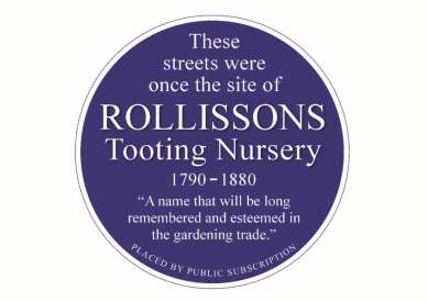
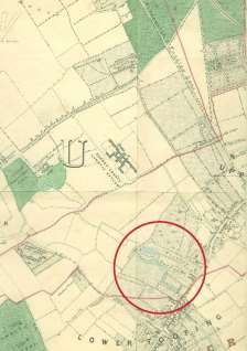
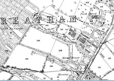
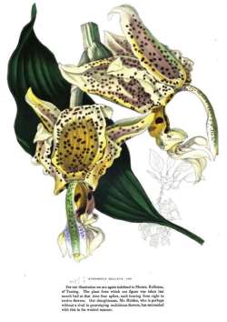
We hear of an orchid from Java being exhibited for the first time there in 1842. In a gardening magazine there was a beautiful drawing of an exotic plant being sent to Rollissons from Madagascar or Nepal.
In the Journal of Horticulture around 1871, Burntwood House is reported to have had prize-winning grapes in the Royal Botanic Society’s Show.
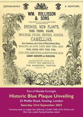
The ever-increasing availability of plants, exotic and native, from trees to small flowers and plant foods, gave both large estates and terraced housing a pioneering chance to garden in a progressive way.
[ADD SOMETHING ON THE WILSONS AS NEAR-NEIGHBOURS PIONEERING NEW PLANTING WILD GARDEN STYLES]
To conclude, drawing information from census details and the commercial aspects of the wider area shows how the early part of our period – early to mid 19th century – was a turning point.
The 1851 census quotes a population of 10,560, and a small proportion, around 300, lived in South Battersea, mainly within the 28 large houses “between the Commons”. Roger Logan stresses how few of the residents then could have imagined the changes that were about to alter their local landscape. He also points out that some, by looking north, seeing the development of Battersea New Town and Nine Elms, may have sensed dramatic change ahead.
Logan continues [with the following evocative description]:
Picture yourself at the crossroads of Battersea Rise and Bolingbroke Grove. Look south along the Grove, wending its undulating way towards Nightingale Lane, and observe on the right the rough open expanse of Battersea West Common (what is now part of Wandsworth Common). Only one railway line crosses the Common…
In the middle distance … is a windmill and behind the newly built Surrey House of Correction, better known now as Wandsworth Prison. From the spot where you are standing, look down Battersea Rise noting the few cottages that exist thereabouts. Further east, on the other side of the valley, is a substantial house, with other houses and their grounds stretching away into the distance along the edge of Battersea East Common (part of Clapham Common).
Down in the valley bottom is a stream, the Falcon Brook; by the side of it is a farm . . . Open land exists between that farm, our vantage point, and the first of the five big houses in Bolingbroke Grove, on the site of Bolingbroke Hospital. It is in Bolingbroke Grove that this history begins…”
(Roger Logan, “Between the Commons , South Battersea's Formative Years 1851–1900”, Wandsworth Historical Society, Wandsworth Paper 15.)
As a final visual signpost to how Bolingbroke Grove looked at the end of the 19th and start of the 20th century, the images below are evocative of a moment in time when life was changing at pace.
The first image, of 1883, shows the view from Bolingbroke Hospital in 1883, showing the west-facing view across Wandsworth Common – an aspect which also provided fresh air for the patients. The Common was probably still quite rough and wild.
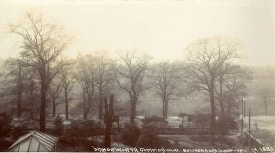
Wandsworth Common from Bolingbroke Hospital, 1883
The second image, of 1910, shows the twin row of formally planted, established and single species trees lining Bolingbroke Grove. The path looks of hard materials of stone and gravel while now it is grass and compacted earth. Ironically, this image shows the area to be more formal than we see today – a revealing fact that in recent years the Common has become more naturalistic and the ecological management allows for more biodiversity and informality.
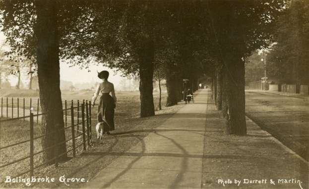
Bolingbroke Grove, c.1910
[H: SHOULD THIS SECTION BELOW BE INCLUDED HERE AT END OF SECTION TO REFERENCE THE ONLY SURVIVING ‘RELIC’ FROM THE LANDSCAPE OF THIS PERIOD BEING THE FOLLOWING:
There is very little remaining for the Five Houses and pre-Victorian days except for a stable-block to Dent’s House between Gorst and Broomwood Roads but it is surrounded by houses, and reached only by an alley from 1B Gorst Rd. There is also a length of old boundary wall between the garden of 35 and 36 Bolingbroke Grove still visible from Bolingbroke Grove.]