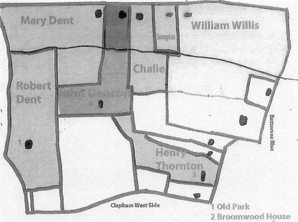
Land ownership around Bolingbroke Grove and Battersea Rise, based on the 1838 tithe map
Build 9 — 2 October 2026
Part 1 of The Five Houses of Wandsworth Common
The richest crop for any field
Is a crop of bricks for it to yield
The richest crop that it can grow,
Is a crop of houses in a row
In 2022, Stephen Midlane and Philip Boys, from the Friends of Wandsworth Common's Heritage Group, proposed a challenging collective project: to research and document the “Lost Houses and Gardens of Wandsworth Common”. Old maps of the area clearly showed a number of houses, small and large, most of which had disappeared by the late-19th and early-20th centuries. Numerous volunteers became involved in this fascinating initiative, each choosing from the long list of candidate houses.
The first to be studied included the "Five Houses" built along the east side of Wandsworth Common in the late 18th century. Initially the road that passed their front gates was called Five Houses Lane or Road but is now
A small group (two of whom live on Bolingbroke Grove itself) rose to the challenge. While researches continued, progress was demonstrated in several presentations to the Friends and to the Wandsworth Historical Society
It soon became clear that there was considerable interest in these and other houses on and around the Common. This book, which we hope will be the first of many, is the result.
Sarah Vey
Henrietta Gentilli
Mark Luboff
Philip Boys
Many were deliberately built facing the Common. Most were cited on main roads around or across the Common (East Hill, Nightingale Lane, Trinity Road), or slightly back from the Common, but not in side streets (which are mainly a late-19C creation, as we shall see.)
Some but not all are named on this 1868 map. Other names may be retrievable. Names changed (e.g. with changes in their owner or lessee. Often simply named after their owner/lessee, or e.g. after trees (Elms, Mulberry, other? etc). Or as in Bramblebury House, formerly Heathfield House
It may be worth limiting this to houses named or clearly present in the 1860s' Metallurgicon. Very diverse - Allfarthing Manor, institutions (e.g. schools), Farms, Prison Turret houses etc - but most were detached villas or small mansions
Building dates (or earliest representation on a map). Demolition dates. Perhaps list roads that now occupy the site.
The houses and gardens may have disappeared, but often leave traces. The route taken by a road. Road-names. Substantial walls that once separated adjacent estates. The most obvious case is the Toast Rack, once an indistinguishable part of the Common, then enclosed for nurseries and scattered houses, that now reaches out like a ? into the Common.]
| House No. | House Name | Built | Demolished | Location |
|---|---|---|---|---|
| 1 | Bolingbroke House | 1777 | 1937 | Between Wakehurst Road & Belleville Road |
| 2 | The Grove / Grove House | 1777–78 | 1889 | Between Kelmscott Road & Bramfield Road |
| 3 | Bolingbroke Grove House | 1777 | 1864 | Between Cobham Close & Darley Road |
| 4 | The Elms | 1777 | 1880 | Honeywell Road |
| 5 | Dent’s House | 1777–78 | 1881–2 | Between Gorst Road & Dent’s Road |
This Introduction aims to:
1. Provide context and background to the development of the land and the building of the Five Houses;
2.
3.
4. Provide a series of maps showing how the area changed from before the houses were built to a period just before the houses were demolished; and
5. Show how the location of the Five Houses between the Common and the Falcon Brook influenced later road and house construction .
In the late 18th century, five houses were built on the east side of Wandsworth Common, with gardens and grounds that ran down to (and in one?some?) cases across the Falcon Brook, a seasonal stream that now runs beneath Northcote Road
The Falcon Brook was culverted (buried underground in a sewer pipe) in the 1860s.
In 1865, the Metropolitan Board of Works formally approved a £30,000 project to cover and enclose the brook as part of London's Victorian sanitation overhaul. This allowed the marshy valley along Northcote Road and St John's Road to be laid out for suburban housing and street development following the opening of nearby Clapham Junction station in 1863.
"They all had pleasure grounds containing landscaped gardens and walks and were described as 'very genteel modern built brick houses which overlook the common towards the west.'”
The early houses around the two Commons were occupied by people of wealth, including Isaac Ackerman (Battersea Rise House), the antiquarian Thomas Astle, and Richard Lovelace and Robert Dent, both partners in Child’s Bank.
Robert Dent built himself a house, designed by Richard Norris the younger, which later became known as Old Park House, on the south-east corner of the area between the Commons in 1775–6, with an associated farm and grounds. Over the next
Lovelace
The sale of a farm in the north-west corner of the area between the commons, owned by Samuel Hoare, to William Willis (partner in the bank Willis Percival and owner of one of the Five Houses) in 1797 completed the picture. After these transactions, the pattern of land ownership remained almost unchanged for about sixty years, and the result is shown in the map below, based on the 1838 tithe map.
Land ownership around Bolingbroke Grove and Battersea Rise, based on the 1838 tithe map
“The Georgian mansions that once graced the west and south fringes of this area, fronting what were then known as Five Houses Road or Lane and Balham Lane (now Bolingbroke Grove and Nightingale Lane respectively), were built on land owned by Robert Dent (d.1805), senior partner in Child & Co.’s bank. Like his near neighbour and banking partner Richard Lovelace, Dent benefited hugely from his association with the Child family, being one of the trustees and main beneficiaries under the will of Robert Child of Osterley Park in 1782.
Dent had taken ground here in the 1760s, presumably on lease from Lord Spencer. Then in December 1772 he bought from Spencer the freehold to all the fields skirting the two roads, with the exception of a plot at the southeast corner (part of Christopher Baldwin’s Clapham Common take) and Bolingbroke Farm to the north-west, in the previous ownership of merchant Samuel Hoare. In all, Dent acquired twenty fields, totalling about 88 acres, at a cost of £5,650. In 1775 he added part of an adjoining field calld Broomfield, procured from Christopher Baldwin.
In 1775–6 Robert Dent built himself a house with spacious grounds, east of the Falcon Brook, known as Old Park House. To the west of the brook, on the land overlooking Wandsworth Common, often referred to by the more general name of Battersea Rise, he erected five more large gentlemen’s residences as a speculation. Four were finished by November 1777 when they were advertised in the London press as “new, substantial-built, brick houses, neatly finished”, for sale or to let; the fifth was completed a year or two later.
Robert Dent had employed the City surveyor Richard Norris (1749–1792) gentleman, to design and build his villa, Old Park House. This was most likely to have been Richard Norris the younger (d.1792), rather than his father (d.1779). Both men held a string of important surveyorships, Norris junior’s including Christ’s Hospital, the Sun Fire Office, the London Assurance Incorporation and the Charterhouse. It is likely that Norris also designed several of the Five Houses; he was the first lessee of at least two of them.
At least one of the Five Houses (Grove House) was the work of John Scott, a Holborn surveyor and associate of the Norris’s, who also held a lease from Dent. Norris’s brother Philip, a Holborn builder and bricklayer trained by their father, witnessed all these deeds and probably handled the construction side; another brother and witness, Christopher, of Lincoln’s Inn, was presumably their lawyer. All four men were listed in newspaper advertisements during the winter of 1777–8 as contacts for prospective purchasers or lessees.
Early descriptions of the Five Houses as “genteel”, “modern”, and “brick-built” suggest equivalence with those going up
These villas were more concise in scale and style than the earlier mansions of Lovelace, Ackerman and Thornton, generally just two to three storeys over a basement and quite plain, in brick or stucco, with decoration limited to bow or bay windows allowing views and perhaps a porticoed entrance. As with the other substantial houses built around the Commons in the late 18th century, those designed by better architects relied for effect on subtle variations in rhythm and proportion. Often the plainness was taken to extreme.
So, the Five Houses were not identical in size or design. The limitations of many of these villas were reflected in their internal planning, the standard form being a compact, but often inconvenient arrangement of rooms, grouped around a central hall or staircase. A farm (Dent’s Farm) was erected at the south end, in the grounds of a house acquired from Dent by his brother William (d.1823); another stood beside Old Park House.
By the 1850s Five Houses