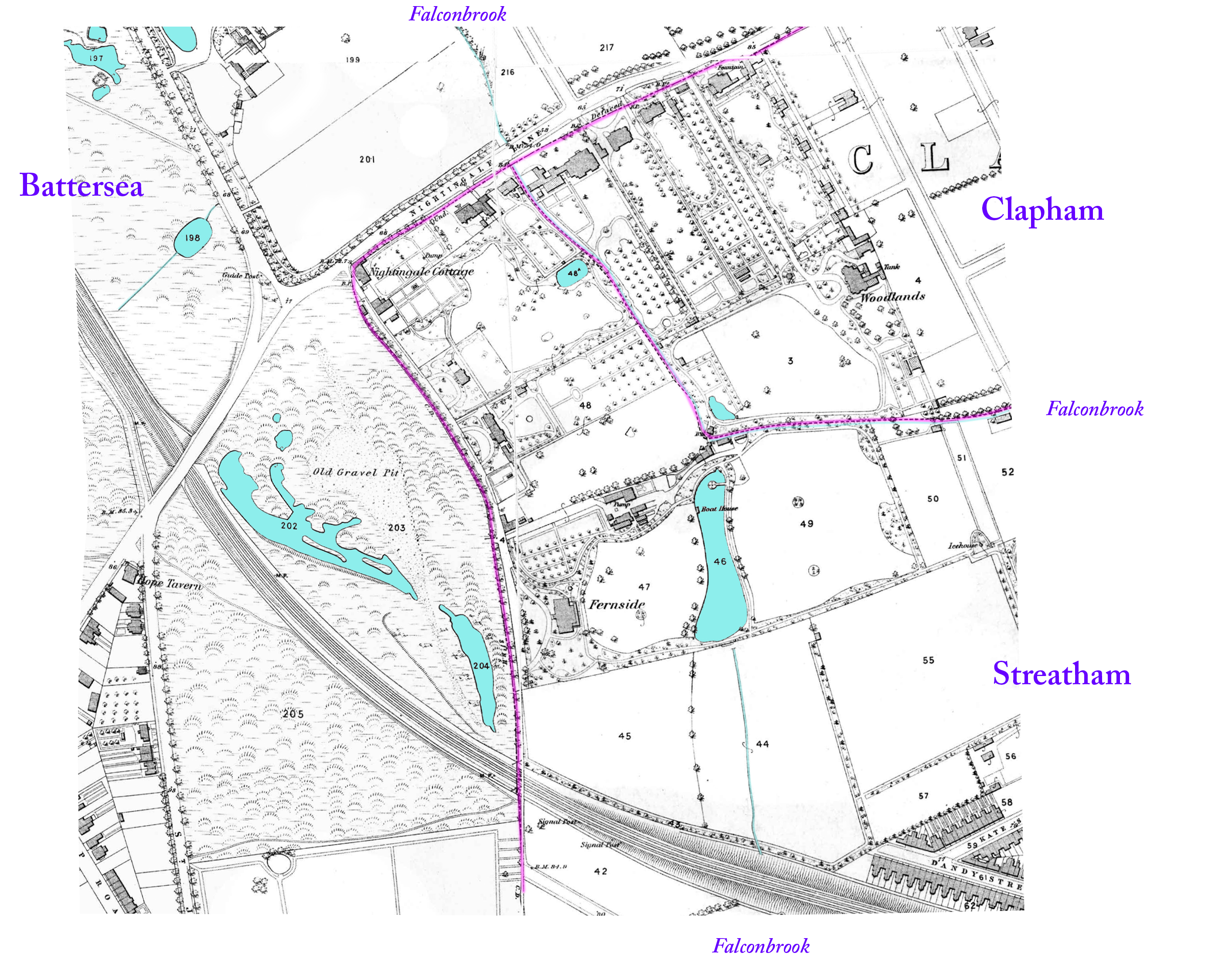
OS map, 1860s
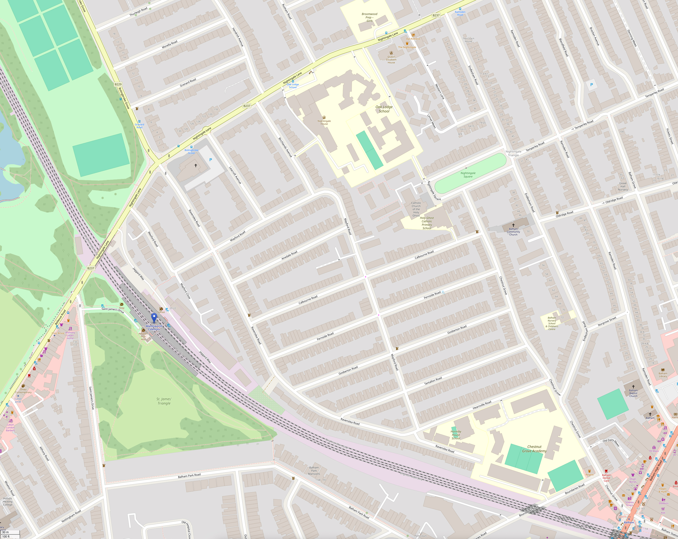
Modern (OpenStreetMap) →
↔
For the sharpest detail, try enlarging this page with your browser's zoom (Ctrl/Cmd and ‘+’), or pinch-zoom on a trackpad or tablet.
Build: 04 July 2026 — v6
Drag the handle across the map to compare the Ordnance Survey map of the 1860s with the modern OpenStreetMap layer of the same area.
For the sharpest detail, try enlarging this page with your browser's zoom (Ctrl/Cmd and ‘+’), or pinch-zoom on a trackpad or tablet.
Build: 04 July 2026 — v1
There is a lot to say about these maps, but it will take time.
Notice the row of houses with substantial ornamental grounds and kitchen gardens, between Nightingale Cottage in the north and Fernside in the south. They face the Common, but are all just inside Streatham parish — this makes sense because Tooting Common was the main local area of “waste” for Streatham. This led to some concern among the householders - they had a powerful interest in “their” Common but no say over what happened to it since they could not attend Battersea or Wandsworth Vestry meetings.
[I have a very nice (anonymous) quote somewhere, probably from James Anderson Rose or Millis Coventry, about how they live on the edge of Battersea/Streatham/Clapham. Find and add.]
Today's roads clearly follow the much older pattern of field and house boundaries.
“The Drive” — not named as such on this map, but this is what it was called [where?]. Clearly the road in front of their houses, which is not, incidentally, an extension of The Five Houses Road/Bolingbroke Grove, curves slightly southward. Clearly it is older than the railway, which cut across it.
It appears to be heading for what we now call Tooting Bec. It may once have been a carriage drive all the way along, but the railway, having cut it short, means that by the 1860s it's just a track ending in the railway line. The alleyway cutting through from St James's Triangle to Balham Park Road is clearly a relic — it follows this old road exactly. There is a Battersea [?] boundary post at its southern end, and a Wandsworth Common post at the northern end.
Fernside house and grounds lay more or less in the area of Calbourne Road, Fernside Road / Gosberton Road. It was large [info]. In the 1860s it was the home of Millis Coventry and Mary, James Bevington's sister. Notice how large the grounds are [? acres].
There's a large boating lake (formed by damming the southern tributary of the Falconbrook), the entry following the line of Mayford Road, which was built over the top of it, roughly between Calbourne and Gosberton.
[Add info / Mary (Bevington) Coventry's letters about why the lake had to be filled in.]
I'm not certain, but I think it likely that the next-door house was James Anderson Rose's — I have an advert from when it was put up for sale in [??], when it was 4 acres etc. I have an image of it somewhere, from a 19th-century magazine, with a commentary — must find and add. The advert says it was 4 acres - for reference, I've outline an area of roughly that size.
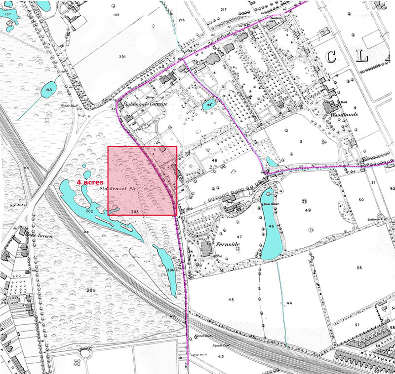
A square showing roughly 4 acres, near what I believe may be James Anderson Rose's house and grounds.
[Next house up?]
Nightingale Cottage, on the corner (more or less today's Mormon car park, where Leacroft Avenue joins Nightingale Lane).
[Names of people living here in 1861, 1871 etc?]
The rough, watery area west of The Drive had been bought by the [Crystal Palace railway company], partly as a source of gravel ballast for the railway line to Crystal Palace in the 1850s. Having completed the route, and extracted most of the useful gravel, they put part of the land up for sale. This would have been attractive to speculative builders, but James Anderson Rose bought it and left it open. [Find and show other maps.]
[Add info about the intention to return it to the Common on JAR's death, but this was vetoed by the LCC and then by Battersea Vestry as too costly for them. Hence the area was built up: Ravenslea Road etc.]
Part of this area was kept by the railway company for coal reserves [used by a coal supplies company?]. A thin section north of the railway line had been used for light industrial use. The area is called Jaggard Way, or similar.
This was acquired by [?] Chester City Council as an investment. They have put in several building applications which were received very poorly by local people, and no permanent building over [?] feet in height has been built there yet. [Add info.]
Survey of London: Battersea, vol. 2, section 49.7
The one surviving station in this sector is Wandsworth Common, south of Nightingale Lane and accessible from Jaggard Way or from a roadway out of St James's Drive. The present site dates from 1869, but it had a predecessor further north, beyond the Nightingale Lane bridge. There lay the original temporary terminus of the WELCPR, constructed from Crystal Palace up to here in 1855–6 before carrying on to the river.
The neighbourhood was as yet all but empty of buildings. In the customarily maladroit way, the station was at first denominated plain Wandsworth, ‘Common’ being added about a year after its official opening in December 1856. Nothing is known of its appearance. It closed in June 1858 when the line continued northwards, and was briefly replaced by New Wandsworth Station, leaving little trace behind.153
The current Wandsworth Common Station owes its existence to the opening of Clapham Junction in 1863, which made New Wandsworth Station obsolete. But an intermediate LBSCR station was now needed between Clapham Junction and Balham, as development was taking off hereabouts, with the Hope Tavern and other buildings mushrooming up on Bellevue Road in the mid-1860s.
The new station opened in October 1869. The original station office, in a minimal brick Gothic style, survives on the north-east side of the line (Ill. 7.48), reached from Jaggard Way. The rest of the station has been much reconstructed in tandem with track widenings. In 1887–8 new platforms, a waiting room and a footbridge were reported.
Works of 1894 corresponded with further widening on the south-west side, when the footbridge was no doubt lengthened. A stationmaster's house of 1897–8 is perhaps the extension north of the 1869 building.
Further alterations costing over £4,000 were made by the builders Kirk & Randall in 1907.154 These must have included the single-storey booking office of brick and brown stone in a handsome Wrenaissance manner protruding on the St James's Road side; it is pierced by what was originally a porte cochère (Ill. 7.49), and hipped back at the end either side of a pedimented gable over a round-headed window. The coverings of the outside platforms have been removed, while those on the island platform have had a shallow pitch added.
Adjacent to Wandsworth Common Station on the north-east side were sidings and a small goods yard, controlled from an office slapped directly in front of the station building in 1891. These have disappeared in favour of commercial premises ranged along Jaggard Way.
Source: Survey of London: Battersea, vol. 2, section 49.7