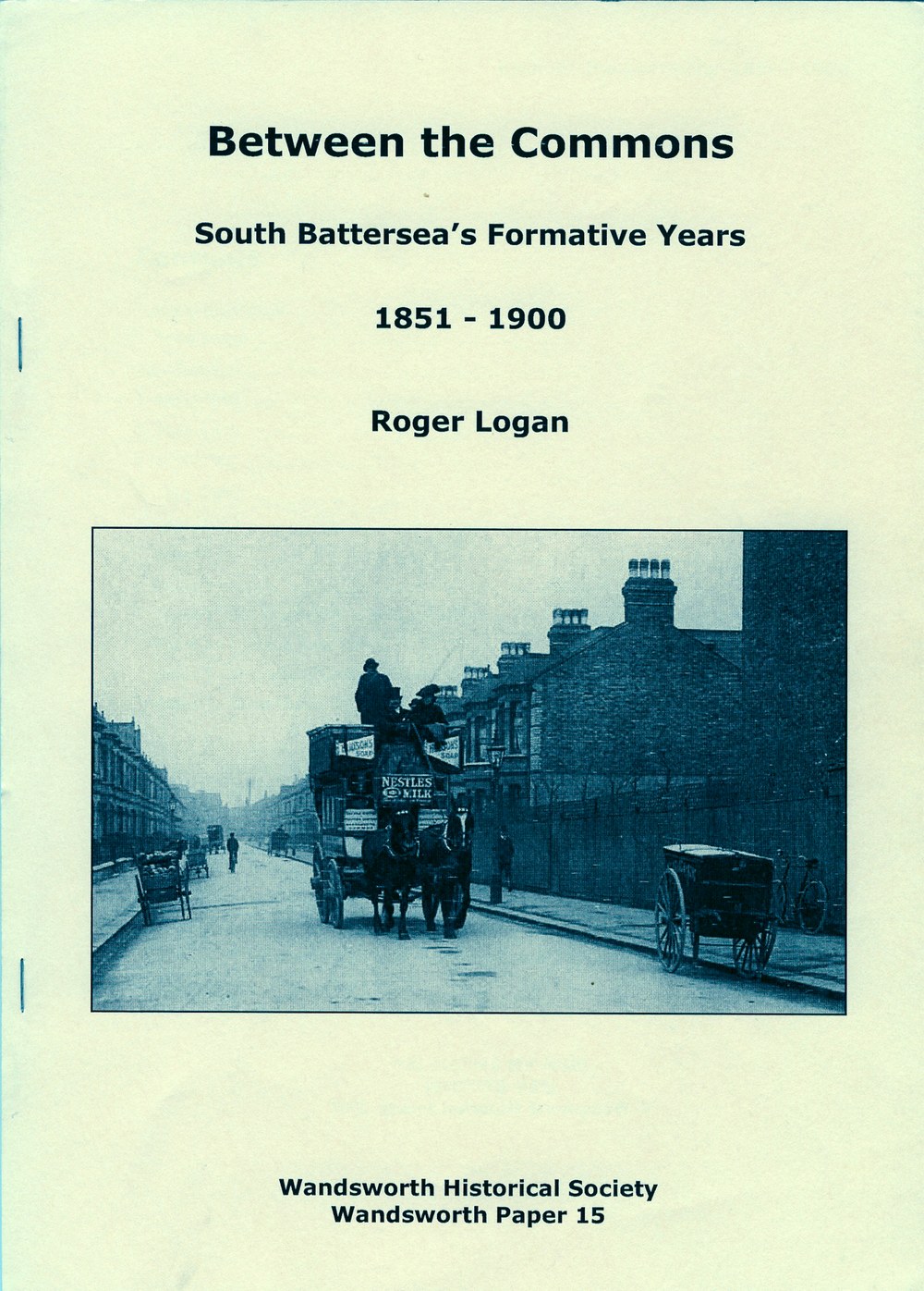
Cover picture: a Thomas Tilling horse bus in Montholme Road, c.1900.
Build 5 — 9 Aug 2026
Roger Logan, Between the Commons: South Battersea’s Formative Years, 1851–1900 (Wandsworth Historical Society, Wandsworth Paper 15, 2007), transcribed by Philip Boys with AI-assisted manuscript reading by Claude (Anthropic), August 2026.
Cover picture: a Thomas Tilling horse bus in Montholme Road, c.1900.
[This is a complete transcription of Roger Logan’s Between the Commons (Wandsworth Historical Society, Wandsworth Paper 15, 2007; ISBN 978 0 905121 18 5), itself a revised edition of his earlier South Battersea. The book’s fifteen figures (sketch-maps and photographs) are reproduced below at their original positions in the text. Please cite the Wandsworth Historical Society and Roger Logan’s original paper if quoting from this text elsewhere.
See also our companion page, South Battersea, 1851–1900: The Making of a Suburb, which brings the book’s six sketch-maps (Figs. 2, 4, 6, 11, 13 & 15) together as an interactive year-by-year slider.]
– List of Illustrations
– Editor’s Note
– Introduction
– 1 1851–1860
– 2 1861–1870
– 3 1871–1880
– 4 1881–1890
– 5 1891–1900
– Postscript
– Annexes
– Annex 1 – The Five Houses in Bolingbroke Grove: 1851
– Annex 2 – Chatham Road: March 1860
– Annex 3 – Occupancy Figures: 1878 and 1880
– Annex 4 – Street Names: 1855–1900
– Back Matter
Thirty years have passed since this book first appeared under the title of South Battersea. It was immediately well received and, to the regret of many, it has long been out of print. The publication of this new edition has provided an opportunity for making a small number of corrections to the original text, and to bring up to date a few details written in the 1970s that are no longer accurate. In the same vein, the change of title is intended to reflect the distinctive phrase often used by local estate agents today. The Wandsworth Historical Society is grateful to the author for allowing his original research to be republished.
The Society’s thanks also go to the Wandsworth Local History Service at Battersea Library for providing all of the images that appear in this publication, and to David Ainsworth at the WLHS for his valuable advice on a number of matters connected with the project. The plan of the area that appears on pp. 4-5 is reproduced from the Ordnance Survey map of 1916 with the kind permission of the Ordnance Survey. All of the other maps are the work of the author. NR
Over 20,000 people nowadays live within the area known as South Battersea, the boundaries of which are roughly down Nightingale Lane, along Bolingbroke Grove, down Battersea Rise and up along Clapham Common North Side, thence back across Clapham Common to the corner of Nightingale Lane (see fig. 1 overleaf). Some of the residents of this area mistakenly believe themselves to be in Clapham, Balham or Wandsworth. However, this is all part of the ancient parish of Battersea, which has grown from the original island settlement in the marshy land bordering the Thames, whose founder, Beaduric, gave his name to the district, possibly as early as the sixth century AD.
Early details of South Battersea are not plentiful and it is not the intention here to speculate on matters that may or may not have taken place before the middle of the eighteenth century. It can however be stated as fact that between 1750 and 1850 the area became one of farms and privately owned ‘country’ estates on which large houses were sited, most of them located around the edges of the manorial ‘wastelands’, that is, today’s two commons. Little has been published about the residents in the latter half of the eighteenth century, but from the evidence of maps and contemporary documents it is clear that the occupancy of the area was sparse, there being only some thirteen large houses as late as 1792.
The names of some of these new residents are still remembered today: Henry Thornton, a city banker and Member of Parliament for Southwark was one, William Wilberforce was another, together with his associates, James Eliot and Charles Grant. Christopher Baldwin, a Surrey County magistrate, was in residence as early as 1761, while Thomas Astle and the Ashness and the Chalie families also settled here during this period. Clearly, with its good access to and from the City and its healthy situation adjacent to the gravel plateaux of the commons, South Battersea was, for successful merchants and men in public life, an attractive area in which to live. This was the pattern that developed and continued to exist until it was replaced by an entirely new sort of residential development; it is the emergence of the latter that is dealt with in this history.
Estate development for building purposes was, of course, not a phenomenon unique to Battersea. All around the periphery of the cities of London and Westminster the provision of housing became one of the major sources of employment, and the results of such endeavour remain much in evidence even today. The progress of construction has been examined in some detail, with the result that a building cycle indicating periods of greater or lesser activity has been identified. It is interesting to note that the overall pattern for South Battersea does not deviate greatly from that of greater London.
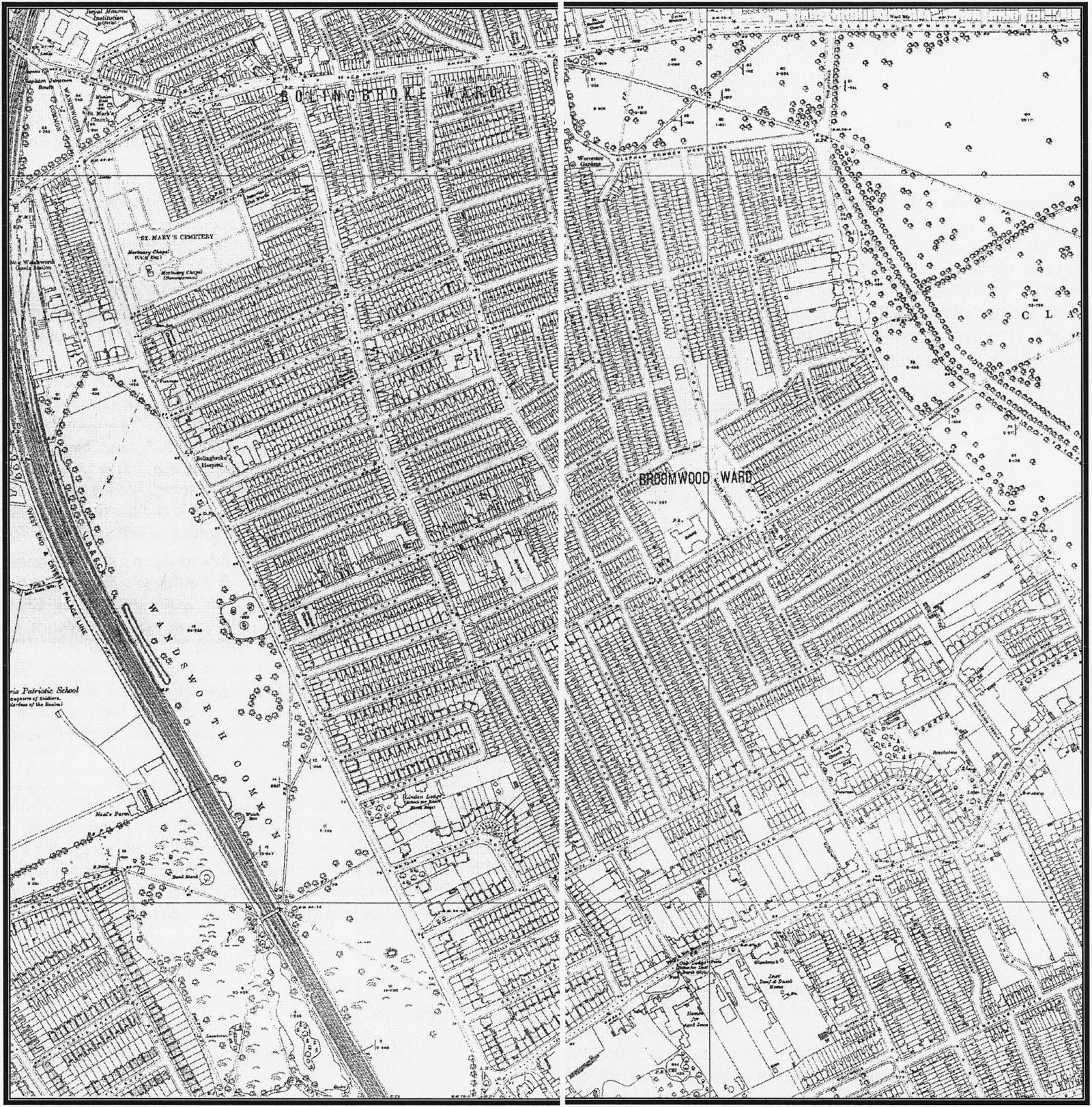
Fig. 1. OS map of South Battersea, 1916, spanning pp.4-5: shows Bolingbroke Ward and Broomwood Ward, St Mary’s Cemetery, Wandsworth Common, West End & Crystal Palace Line, Bolingbroke Hospital, Linden Lodge, and the dense residential grid of streets that developed either side of the railway and the common.
According to the census of 1851, the population of the north-east Surrey parish of Battersea that year was 10,560, of whom just over 300 lived in the area of South Battersea. The majority of those residents occupied the large houses of the area, about twenty-eight in number, either as members of the family or household servants. The total of the latter was some 143, almost as many as the 161 family members. The remaining few inhabitants occupied cottages close to the junction of Battersea Rise and St John’s Road. Fig. 2 illustrates the location of the houses and the overwhelming area of open land then existing.
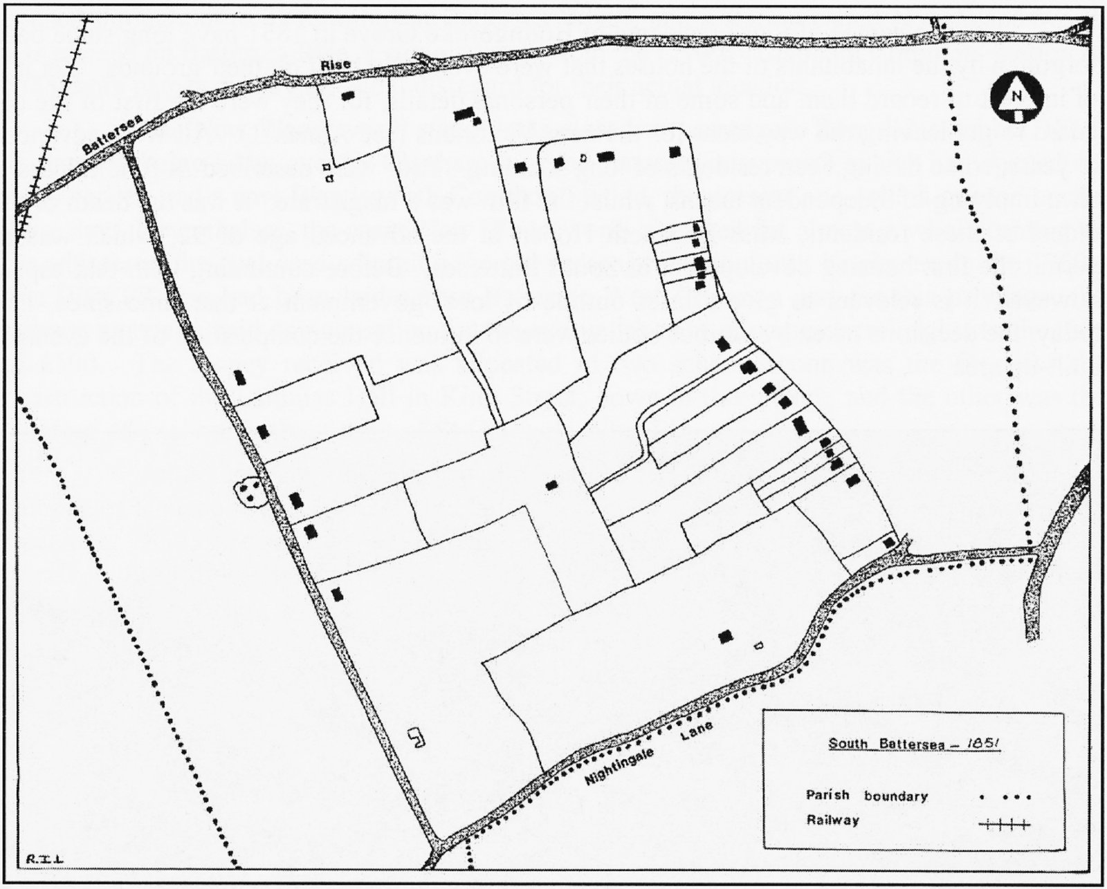
Fig. 2. Sketch-map of the area in 1851, by R.I.L. Shows Battersea Rise, Nightingale Lane, the parish boundary and the scattered large houses and outbuildings of the area, still almost entirely open land.
Few people at that time could have foreseen the changes that were to take place around them in the next fifty years or so. Some would have been aware that changes must come, by looking to the north and seeing the expansion of the village, and to the east, where the growth of Battersea New Town and the Nine Elms district was apparent. To comprehend their feelings, we need to transport ourselves back to the time before the houses came, back to a vanished landscape.
Picture yourself at the crossroads of Battersea Rise and Bolingbroke Grove. Look south along the Grove, wending its undulating way towards Nightingale Lane, and observe on the right the rough open expanse of Battersea West Common (what is now part of Wandsworth Common). Only one railway line crosses the common, that of the London and South Western Company (LSWR), concealed in a cutting; a railway station strangely named ‘Clapham Common’ exists adjacent to Battersea Rise (fig. 3). In the middle distance alongside the railway is a windmill and behind that the newly built Surrey House of Correction, better known now as Wandsworth Prison.
From the spot where you are standing, look down Battersea Rise noting the few cottages that exist thereabouts. Further east, on the other side of the valley, is a substantial house, with other houses and their grounds stretching away into the distance along the edge of Battersea East Common (part of Clapham Common). Down in the valley bottom is a stream, the Falcon Brook; by the side of it is a farm, situated roughly at the junction of today’s Northcote and Shelgate Roads. Open land exists between that farm, our vantage point, and the first of the five big houses in Bolingbroke Grove, on the site of Bolingbroke Hospital. It is in Bolingbroke Grove that this history begins.
The names of those residents of Bolingbroke Grove in 1851 have long since been forgotten by the inhabitants of the houses that were eventually built on their grounds. Yet it is of interest to record them and some of their personal details, for they were the first of the old guard to go, leaving the way clear for the new Victorians (see Annex 1). All were advanced in years, some having been residents of long standing. Four were described as fundholders, a term implying of independent means, whilst the fifth was a magistrate. It was the death of the oldest of these residents, Miss Elizabeth Hoper, at the advanced age of 92, which was to permit the first housing development in South Battersea. Before continuing with that aspect however, it is relevant to give a brief outline of local government at that time since, like today, the decisions taken by various bodies were to influence the composition of the eventual built-up area.
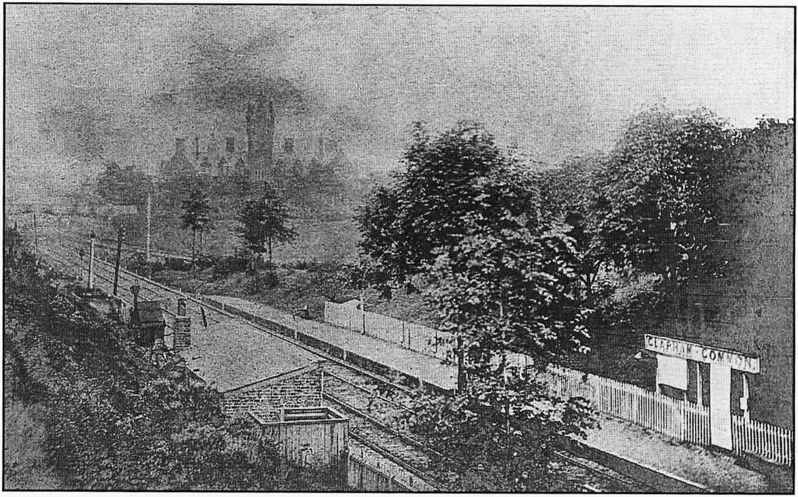
Fig. 3. Clapham Common Station with the Royal Victoria Patriotic Asylum in the background, c.1862.
[PB: The background building is in fact the Royal Masonic School for Girls (1853), built a few years earlier than the RVPA (Girls). Demolished in 1930s, Peabody's St John's Hill Estate was built on the site.]
Coincidental with the first development came the creation of the Metropolitan and the District Boards of Works. The former, a forerunner of the London County Council (LCC) and Greater London Council (GLC), was the top tier. The Wandsworth District Board of Works (WDBW) administered the area of the parishes of Battersea, Clapham, Streatham, Tooting, Putney and Wandsworth. Under the District Board were the local committees and the vestries, whose interests were also associated with church matters. This new structure came about as the result of the passing of the Metropolis Management Act of 1855. Thus it was that the historic changes that were to take place around London did so at the same time as the most extensive re-organisation of metropolitan administration up to that date.
In the five years that followed the death of Miss Hoper in 1852, the property changed hands several times, but by July 1856 the WDBW had taken a lease on the house, where it was to stay for two years. In the same year, not far from the District Board’s headquarters, a significant development took place. This was the opening on 1 December 1856 of a temporary terminus for the West End of London and Crystal Palace Railway (WECPR), more or less where the present Wandsworth Common Station stands. This terminal station lasted only about fifteen months, for on 29 March 1858 the railway was opened throughout to its terminus at Battersea Wharf, and a station called New Wandsworth was opened on Battersea Rise, a stone’s throw from the LSWR ‘Clapham Common’ station of 1838, both names displaying equal disregard for their actual location.
The New Wandsworth station was closed to passengers from 1 November 1869, its function being taken over by Clapham Junction (another misnomer), which had opened six years earlier, and a new Wandsworth Common Station, the present one, which opened on the same day. Nevertheless, the name New Wandsworth persisted for almost a whole century as the address of the coal yard adjoining the old passenger station until its closure in the 1960s. The WECPR line had been laid across Battersea West Common and for this privilege, the railway company paid compensation for the extinguishment of commoners’ rights to the tune of £500. The money received was allocated to two schemes: one was the fund for the construction of the Lammas Hall in King Street, down in the village, and the other was the building of a school in the district of St George’s, Nine Elms.
An interesting reference to the stations of both the LSWR and the WECPR companies is made in a periodical circulating in the district called the Clapham Gazette. The December 1856 issue says, ‘We find that it is the intention of Mr Mason to start an omnibus [service] three times daily from the Swan at Stockwell to the South-Western Station on Wandsworth Common and the Crystal Palace [line] station at the top of Nightingale Lane.’ The South-Western station is also mentioned in the WDBW’s minutes where ‘the Surveyor laid before the Board a list of the public footpaths in the district’, and it was resolved that ‘the Surveyor be instructed to repair the footpath on Wandsworth Common leading from Bolingbroke Grove to the Clapham Common Railway Station’
One of the many amenities taken for granted today is street lighting. In the 1850s, the undertaking was minimal by comparison. With only the main thoroughfares in existence, the job was in the hands of contractors appointed by the WDBW, and in 1857 several resolutions were passed concerning South Battersea:
Resolved that seven additional public lamps be placed in Nightingale Lane at a distance of six chains apart and that the cost of lighting such lamps be charged as follows: three to the Parish of Clapham and two each to the Parishes of Battersea and Streatham
Resolved … that the Surveyor be authorised to light the lamps erected in Nightingale Lane with gas
Resolved … that the Clerk be instructed to write to the Phoenix Gas Company to ascertain upon what terms they will light the public lamps in Bolingbroke Grove
Resolved … that instructions be sent to the Phoenix Gas Company to light the road past the St James’s schools and also those in Bolingbroke Grove, at the price of £6 12s per annum.
A further new local amenity being considered during 1857 and one which is still in existence today was the footbridge over the WECPR line on Wandsworth Common near the large pond. Once more it was the WDBW which initiated the matter, deciding in October 1857
that the Surveyor be instructed to communicate with the Engineer to the Crystal Palace Company with a view of procuring for the accommodation of the public foot bridges over the Crystal Palace and West End Railway in … the path on Wandsworth Common leading from Mr Neal’s Nursery, round towards Nightingale Lane.
Shortly after, the Surveyor reported on his communication with the railway company, as a result of which the Clerk was directed to make the appropriate formal approaches. In December, ‘a letter was read from the Secretary to the WEL and CPR dated 30th ultimo stating that the Company were willing to construct the footbridges requested’
It was at the end of 1857 that the first official evidence appears of the existence of a housing development on the land of the late Miss Hoper. This evidence is in the form of a building notice to the WDBW ‘from Mr F. Newman, for a dwelling house at Bolingbroke Grove, Wandsworth Common’ This notice was followed early in 1858 by others referring specifically to Chatham Road: ‘from Mr Stapleton, for a house in Chatham Road’, and ‘from Mr Collyer for three houses in Chatham Road’ At this point it is opportune to attempt to establish the reason for Chatham Road being so called.
The earliest mention of the name that has come to light is in 1855, in a lease that bears the name Charles Dungate. He was a grocer, trading and living at The Polygon, Clapham, and his connection with the development is not clear, but his name appears a number of times right down to the late 1880s in connection with houses in Chatham Road. Might it have been he who originated the road name, perhaps linking it to his family’s origins? Alternatively it may be that the person suggesting it was attempting to draw attention to the association of William Pitt, Earl of Chatham, with Battersea Rise House, home of the Thornton family. A third suggestion is that the choice of name had some connection with the railway line recently laid across the common, which for a short time afforded access to Victoria for Chatham trains. But since this arrangement, which lasted less than two years, did not come into operation until December 1860, it requires a remarkable degree of foresight for it to have influenced an event as early as 1855! A fourth idea stems from the fact that the National Freehold Land Company (NFLC) had an interest in this development. They were one of the several freehold-land companies that proliferated in the mid-nineteenth century, seeking to increase the electorate by sale of freehold plots, upon which houses were usually built. The NFLC worked in opposition to the Conservative Land Society and was a Whig/Liberal body. Pitt, of course, had been a notable Whig prime minister and the NFLC may have sought to commemorate him in the naming of Chatham Road. Whatever the origin of the name, the unique feature about the naming of Chatham Road is that it does not appear to have received the sanction of the Metropolitan Board of Works (MBW), possibly because it had been laid out, if not built along, before the constitution of that body in 1855. Interestingly, the MBW authorised in October 1862 Chatham Street in North Battersea.
It was mentioned earlier that the WDBW had used the house of the late Miss Hoper as its offices for two years. Their tenancy lasted until July 1858 when they were given notice to vacate by the freeholders, the British Land Company. At the invitation of the Board of Poor Law Guardians, the District Board then met at offices located at the Wandsworth and Clapham Union Workhouse on St John’s Hill. This arrangement lasted until October 1858, when the Board moved into new premises on Battersea Rise, again on a leasehold basis. Their original property was by this time back in domestic use, being the home of James Lord.
During this period of changing offices, the WDBW had received further notices of erection of new buildings in Chatham Road, these continuing to arrive throughout 1859. One interesting matter that arose during 1859, beginning in September, was the erection by Thomas Stapleton of a signpost on the path in front of his house in Chatham Road. The Clerk to the District Board was asked for his advice as to whether or not the Board had power to order its removal; his report concluded that as the road was a private one the Board could not interfere in the matter. The signpost may well have been the forerunner of the pub-sign that can still be seen (in 2007) outside ‘The Bolingbroke’ public house in Cobham Close, and could signify the date when Stapleton’s premises were first used as a ‘beer-house’ [1]
Although there was no further housing estate development in 1859, there was one important and influential event yet to take place that helped to shape the area. This was the commencement of negotiations for the purchase of land to provide for a new burial ground for Battersea Parish. Established in 1855, the Battersea Burial Board had been considering since its inaugural meeting in May that year the provision of a site for an extensive new cemetery within the parish boundaries. Several sites had been examined, including one on ‘that part of Battersea West Common called Wandsworth Common’ The trustees of the newly built Royal Victoria Patriotic Asylum had objected to this proposal and like several other proposed sites it was abandoned. In April 1859 the Burial Board requested its Clerk ‘to apply to Henry Willis Esq., the owner of land at the corner of Five houses road [Bolingbroke Grove], Battersea West Common, the contemplated site for the Cemetery, to ascertain the terms and price for the purchase of the said land’.
The Willis family, although owners of Bolingbroke Grove House, had not lived there for some years, Henry Wheeler having been the occupier since 1852. Sara Willis, widow of William Willis and mother of Henry Willis, died in November 1857, and it appears that the whole property came up for sale in July 1858. Wheeler purchased the house and some of the land, the remainder not being sold. It was this latter portion that attracted the attention of the Burial Board.
At the Board meeting of 13 April 1859, the Clerk reported the favourable reaction of Henry Willis to their approach, and the Board on hearing this, decided to offer £500 per acre for the land, the area of which was 8 acres 35 perches. Negotiations proceeded well and by June a draft contract had been drawn up by Willis’s solicitors and was with the Burial Board for consideration. There was one hurdle to be overcome: obtaining the approval of the Secretary of State for the use of the land as a cemetery. On his behalf the Inspector of Burial Grounds raised several queries that had to be answered, but after a site visit by the inspector and the receipt of the replies, the Secretary of State gave his approval at the end of June.
There was, however, one major setback. The Burial Board had been constituted by the Battersea Vestry, and it was therefore necessary to obtain approval for the expenditure of the sum of £8,000, the amount now required for the purchase of the land. The report of the Vestry meeting convened to discuss the matter makes astonishing reading. The following extract from the report given by Mr Reynolds, the Board’s Solicitor, conveys the atmosphere of what must have been an entertaining evening:
The proceedings throughout were of the most tumultuous character, the objectors, many of them indulging in gesticulations, groans, hisses and personalities made it impossible for any one to hear what was going on much less to have an opportunity of calmly discussing the subject.
Amidst this scene of chaos, the motion ‘that this vestry does sanction the raising and expenditure of Eight Thousand Pounds’ was put. The resulting show of hands indicated four persons for, sixteen against the motion; the Vestry had declined to give the necessary financial approval.
The Burial Board, however, was not to be frustrated in the execution of its obligations. It immediately formed a sub-committee to prepare a memorial to the Secretary of State stating the case of the Board for its proposals, the rejection of this case by the Vestry, and requesting the authorisation of the Secretary of State to go ahead with the scheme. This memorial was forwarded to the Secretary of State at the Home Office, Sir George Lewis, on 16 August 1859. To reinforce its views, the Board sent a deputation to the Home Office on 23 August. Those objectors who had successfully swayed the Vestry were not to be outdone, sending to the Secretary of State a list of objections, which he subsequently asked the Burial Board to respond to, which it did in a forcible manner.
Most of the objections were frivolous, considering the recognised need for the provision of a new cemetery, but one is deserving of attention. This was ‘that the Vestry have heard that the remainder of the land has been contracted to be sold for building purposes and in the course of a few years, the burial ground will without doubt be surrounded by houses’ There appears to have been no foundation for that belief, yet in this case the Vestry’s prediction was accurate. At the time, however, the Burial Board dismissed the matter in the following way:
The spot selected, as Dr Grainger will tell you, is admirably adapted, having a belt of trees surrounding it, and thus forming a natural fence to the road side, and being situate moreover in a portion of the parish where the population can never become dense, Wandsworth Common being on one side, Clapham Common on the other.
Dr Grainger belonged to the Burial Acts Office and it was from him that the next move came. This took the form of a letter to the Burial Board and referred to a ‘proposal that a Union of the Parish of Battersea with the neighbouring parishes of Clapham and Wandsworth should be effected for providing a burial ground’ It would appear that this was merely another ploy by the small group of dissenting vestrymen, the Clerk to the Burial Board being able to report that Clapham had its own Burial Board and had made arrangements to bury its dead at Norwood, whilst Wandsworth did not have a Burial Board nor did it envisage a need to have one for a period of at least ten years.
The overall position thus clarified, the Home Office decision was made at the end of October 1859:
Referring to your memorial received in August last from you as Chairman of the Burial Board for the parish of St Mary, Battersea, I am directed by the Secretary of State, Sir George Lewis, to transmit to you herewith a Warrant under his hand, pursuant to the 6th Sec. of the 18th and 19th Vict. Cap. 128, authorising the Burial Board to expend the money required.
The Board could now proceed. At its meeting of 28 November 1859, the seal of the Board was affixed to the Contract of Agreement for the purchase of the site, and the scale of burial fees and conditions for interment were agreed by the Secretary of State in early 1860. To ensure that nobody illegally entered the site, the Burial Board resolved that ‘a notice board be written and fixed, cautioning trespassing and turning cattle and damaging fencing in the Burial Ground at Battersea West Common, and that all cattle found thereon will be impounded’ By November 1860 the various construction works had been completed and the new cemetery came into use. The state of development at the end of the first decade of the second half of the nineteenth century is shown pictorially in fig. 4 From this it will be apparent that little had occurred in the way of housing estate development, and that the only major event had been the formation of the cemetery.
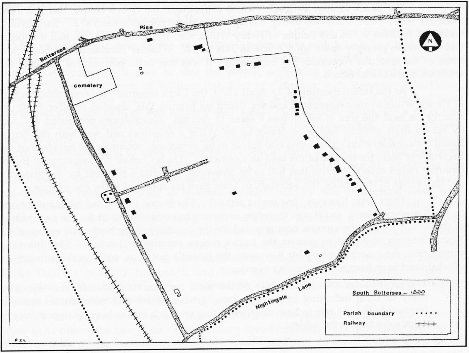
Fig. 4. Sketch-map of the area in 1860, showing the new cemetery laid out beside Bolingbroke Grove.
Note 1. ‘The Bolingbroke’ was permanently closed in 2003.
At the beginning of 1861 no housing development other than that in Chatham Road existed in South Battersea (see Annex 2). With this exception and the part of the Willis estate taken for the cemetery, the established land use prevailed. The three farms of the area – Bolingbroke, Dent’s and Old Park – remained. The establishment and growth of the one identifiable housing development must therefore be considered as unique and worthy of close examination.
The reasons for this initial development are not obvious. Despite statements to the effect that development took place because of the railways, such reasoning is unsound. The types of people moving into this new area were not likely to benefit from the existence of a transport system. Tradesmen such as agricultural labourers, domestic gardeners and carpenters did not need to catch the 8.15 to town for work. Nor did the lamp-lighter, the wood-carver or the pianoforte master. Yet these were the people who appear as residents in 1861. It was in effect a ‘village’ settlement, populated by pioneers. Predominantly the occupations of the men fell within the artisan/labouring classification. There were no city gentlemen, merchants, or ‘persons of independent means’ here, the most elevated person appearing to be Charles Webb (no relation to the Webbs of Webbs Road), who lived at Rose Cottage with his wife and child, and who was a ‘cab proprietor’ [2] Closely following him would have been Mr Erdman, a German teacher, and Charles Ortner, a clerk for the Duchy of Cornwall.
Apart from these few ‘gentlemen’, the occupants of Chatham Road were of much more routine employ, as described above. From Yorkshire, Shropshire and Oxfordshire they came, from the Home Counties, Essex, Kent and the parishes of Surrey. Their ages fell mainly within the 30 to 50 age-group. The properties into which they moved in Chatham Road were domestic dwelling-houses, newly built. Shops are not readily identifiable at this time, but there is evidence of public houses, some of which were called beer-houses, by the late 1850s. The first was the previously mentioned one occupied by Thomas Stapleton; in the early 1860s there were others – the ‘Eagle’ and the ‘Gardener’s Arms’ – whose signs still hang in Chatham Road, whilst amongst those now gone are the ‘George and Dragon’ and the ‘Carpenter’s Arms’ The latter is of interest as Samuel Cutler, the occupier of 77 Chatham Road in 1861 and a carpenter by trade at that time, appears in 1871 as the resident of the beer-house at no. 99, the ‘Carpenter’s Arms’, presumably having become its licensee. These were the newcomers who made Chatham Road the germ of a community.
At this point it is perhaps appropriate to consider what effect the railways had on the development of South Battersea. As already recorded, the LSWR had opened its station (‘Clapham Common’) on Battersea Rise in 1838, served by trains to Nine Elms until 1848 and thereafter Waterloo, and to Wimbledon, Woking and beyond. Next came the WECPR with its temporary terminus at Wandsworth Common from December 1856 until superseded by ‘New Wandsworth’ in March 1858. As its name implies, this line provided access to the Crystal Palace, with connecting lines beyond serving Croydon, Beckenham and even Brighton. The ‘London’ terminus was initially on the south bank of the Thames, adjacent to the newly-completed Chelsea Bridge, at a station called ‘Pimlico’ This was only a makeshift arrangement however, and in December 1860 the line was extended over the river to its permanent terminus at Victoria.
In 1863 an event took place that put Battersea firmly on the railway map: the opening of Clapham Junction. For the first time, through services and inter-change were offered between trains to and from the London termini.[3] The name of the new station, of course, maintained the long-established Battersea tradition of railway misnomers, and a contemporary report of its opening records:
The South-Western has, or rather had, its Clapham Common station, which was a mere trap for the unwary. The luckless traveller who took his ticket for this station was turned adrift on Wandsworth Common, two miles distant from Clapham town. Such excellent sport did this seem to other railway companies that they forthwith joined in together to the number of seven or eight, in the construction of the Clapham Junction station, which deceives ten passengers where the Clapham Common station deceived but one.
Now it might be supposed that with these greatly improved facilities, the estates that were well placed to be served by them would be rapidly developed. In fact this was not the case; indeed it was a full forty years before the last estate was developed. So the impact of the railway, in this district at any rate, must have been considerably less than has been thought. It is perhaps a fair assessment of the position to say that development would have taken place at this time in South Battersea had the railway not existed, but that the later development might not have taken the form that it did.
Although development of Chatham Road continued, no new initiative took place until October 1863. There had been a number of cottages erected along the south side of Battersea Rise on Henry Wheeler’s land in 1862, but these merely added to an existing area of cottages and shops rather than created a new one. This distinction fell to Christopher W Todd whose plans for the creation of three new roads and the building up of Battersea Rise were approved by the MBW on 23 October 1863. The form of development was that of the standard 40-foot-wide road, the names to be Auckland, Middleton and Pelling. The first will be familiar, the second is now called Buckmaster, whilst the third was never built, as will be explained later. Surprisingly, none of the earliest houses erected on this development were included within the re-development of the Auckland Road area, which the Wandsworth Borough Council began in 1977 An interesting feature that survived into the 1970s was a Royal Insurance Company fire plaque on the front wall of 9 Auckland Road, though this has since disappeared. Although the consistent appearance of the two roads gives an impression of uniformity, several builders were involved in constructing the houses over a period of time in both instances, the harmony of appearance presumably resulting from conditions laid down by Todd.
January 1864 saw the WDBW giving instructions ‘for the fixing and lighting of a new lamp at Battersea Rise between the lamp at Bolingbroke Grove and the lamp at the Railway Tavern’ Also that month the Board received from Charles Dungate an application ‘for permission to form a footway 20 feet wide, to lead out of Chatham Road, and to erect four cottages therein’ The District Board was against this, advising the Metropolitan Board that ‘such permission ought not to be granted inasmuch as the cottages would be in a confined situation, and in close proximity to the Falcon Brook Sewer’ Despite this advice the MBW gave the go-ahead to Dungate, permitting the construction of that portion of Northcote Road where the library now stands.
There is evidence that Webbs Road[4], also known as Webbs Lane or Popes Road, existed in April 1864 when it was stated that ‘Mr Lewis Coles had made an application respecting the width of roadway at the end of Chatham Road, called Popes Road’ In reply, the MBW required Coles to set his fence 20 feet back from the centre of the old lane ‘with a view of eventually securing a width of 40 feet for the portion of the road to be newly formed’ The lane itself formed part of the West Side Estate, at that time in the ownership of Charles Webb, a London merchant. The development of this estate is dealt with later.
Despite the fact that building notices for premises to be constructed in the few approved roads continued to arrive throughout the year, it is essential to think of South Battersea as still consisting of open, undeveloped estates. The early transition of the area was slow, a consistent evolutionary process. As a reminder that the landed gentry still played their roles, two small and relatively insignificant events concerning their lives have been selected. In July 1864,
the Battersea Surveyor laid before the Board a letter from Messrs Debenham and Tewson, complaining of damage to the fence of Old Park, Nightingale Lane, in consequence of the recent raising of the road there. The Surveyor stated that it was necessary that a retaining wall should be erected there to support the road and that the present fence should be refixed on the top of the wall; whereupon it was resolved unanimously that such work be executed.
The following month the Surveyor reported that he ‘had seen Mr Jennings on the subject of the cost of erecting the retaining wall to the road in Nightingale Lane … and that Mr Jennings had agreed to contribute half the cost’ Consequently the Surveyor was instructed to execute the work, his suggestion being accepted that ‘the consent of Mr Dent should be obtained for the wall to be built upon his land, as the expense would thereby be less than building it on the road side of the fence’ By October he was able to report that the wall had been constructed and ‘the old fence re-fixed and made good at a cost of £42, whereon it was resolved unanimously that the Clerk be instructed to write to Mr Jennings requesting payment of £21, half of such costs as arranged’
The second incident reflecting the life of the gentlefolk of South Battersea emanated from a large house on the edge of what was then still called Battersea East Common, now Clapham Common. This was ‘Beechwood’, where Sir George and Lady Henrietta Pollock lived. Pollock (fig. 5 overleaf) wrote to the WDBW in September 1864 requesting the erection of additional lamps on the road across the common, presumably The Avenue. The Board agreed to the provision of five lamps ‘between Mr Wainwright’s and General Laurence’s; corner of the road leading to Sir George Pollock’s; corner of the road leading to ‘Broomwood’; corner of the Branch Road to Clapham [Windmill Drive?]; corner of the Branch Road to Nightingale Lane [Nightingale Walk?]’
So far no mention has been made of industry in South Battersea for the simple reason that there was none. Agriculture continued to exist but on a diminishing scale. Late in 1864 the first mention is found of one facet of the development of the community. A notice was submitted to the WDBW for the erection of a new building, a ‘printing factory in a narrow road on the north side of Chatham Road’ This was to be constructed for George Stiff to house the printing works of The London Reader The Board in consideration decided to ‘object thereto on account of the road only being 25 feet in width; and the Clerk was instructed to require Stiff not to proceed with building unless the road is made 40 feet wide’
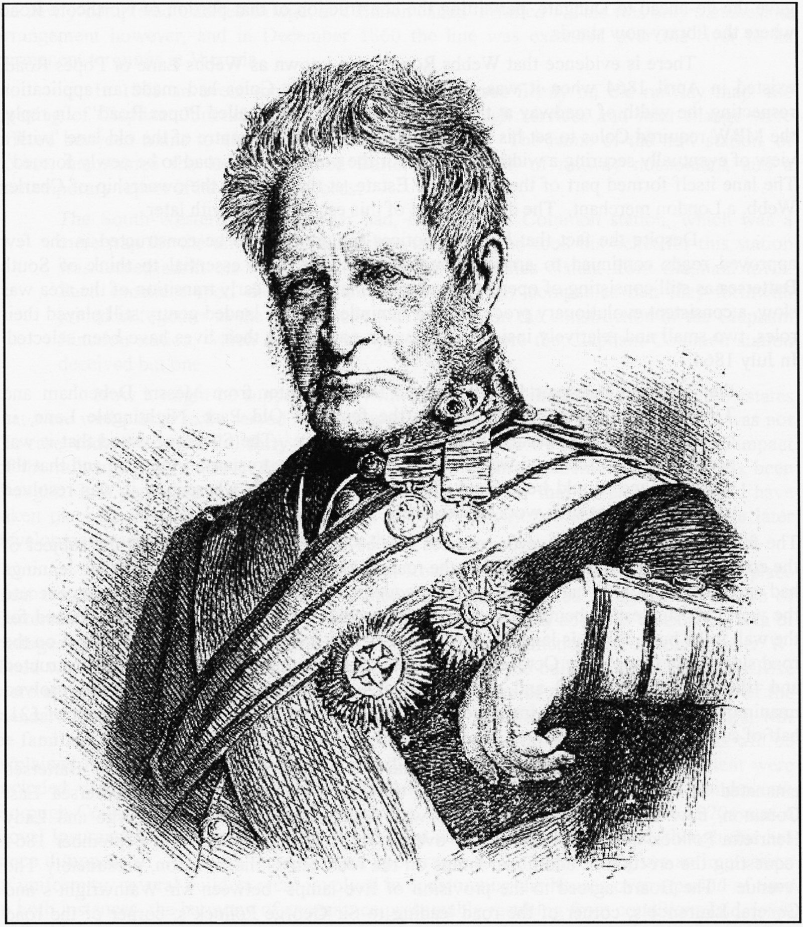
Fig. 5. Field-Marshal Sir George Pollock (1786-1872), veteran of the Anglo-Afghan War of 1842.
Notwithstanding this specific requirement, Stiff appears to have built his factory without providing the wider road, and the roadway narrowed at this point until the latter part of the twentieth century. Quite why the proprietors of the concern should wish to locate their printing factory in such a remote spot is open to debate, but the precedent set was to be followed by several other printing concerns during the decades of development.
Local issues and actions help to give a clearer picture of life at the time. In 1865 the railway company closed a footpath across Wandsworth Common from Bolingbroke Grove to the New Wandsworth Station. This incensed one local resident in particular, J. C. Buckmaster. He tore down the fences and defied the railway company to take action against him. He also approached the WDBW requesting action from it but the Board replied that it was powerless to act. For the next five years, Buckmaster championed the cause of preserving public rights of way, becoming involved later in the struggle to maintain the commons for public use. Not far from the scene of this incident, a positive step taken by the Board induced a grateful response from one local resident. The Board provided the first lighting in the vicinity of the new Auckland Road development in October 1865, a move welcomed by Walter Bishop, a chemist, who occupied one of the shops in the parade on Battersea Rise. In those days the penalty for damaging one of these lamps was a sentence of imprisonment, usually with hard labour. To the person responsible for catching the wrongdoer went a reward, an incentive no doubt to many a policeman.
The development of two roads off Chatham Road has already been mentioned. Another similar proposition arose late in 1865, when a Mr Stonell came forward with a proposal to form a new road, only 20 feet wide, with twelve houses lining it. The District Board were not keen on the idea, but the Metropolitan Board, the ultimate authority, gave permission for its construction. The houses on the eastern side of Stonells Road line a roadway that was not ‘made up’ until the end of the twentieth century.[5] At the northern end, there is a plaque on the side of no. 6 commemorating its completion in 1867
Building in Chatham Road itself had continued over the years. It was, however, still a private road as its condition showed. In an effort to improve it, a letter from Sir Charles Forbes, the owner of ‘Broomwood’ and the estate to the south of Chatham Road, was placed before the WDBW at the end of 1865. At the same time, a memorial was submitted from the owners of property in Chatham Road. Both documents requested its adoption as a parish road. This was duly considered, and the Board agreed at its first meeting in 1866 to the adoption and the making up and paving of Chatham Road, the contract for the required work going to a local man, Mr Neal. The cost of the work was to be met by the owners of property in the road, a system known as apportionment. This was a procedure that was later to be the cause of much concern in another South Battersea estate development.
In March 1866 came a proposal for the next estate development. This was for the formation of new streets on the Old Park Estate, adjacent to Nightingale Lane. The proposal from Messrs Wimble and Taylor contained provision for four new roads, to be called Thurleigh, Sudbrooke, Westerdale and Winchelsea. The first two are easily recognisable, the others are not. They are now Ramsden and Rusham Roads, both forming access roads to the other two. The development included the widening of Nightingale Lane to the standard width of 40 feet. Housing development in these roads was slow, Nightingale Lane being the first to have new large houses built along it. Such houses as did appear were of a spacious type, detached or semi-detached, bearing more of the hallmarks of scaled-down country houses than of the new urban-terrace type being constructed further to the north. Old Park House itself remained standing.
By now the development of Auckland and Buckmaster Roads should have been well under way. In April 1866, however, Christopher Todd applied to vary his original plans by the deletion of the third proposed road, replacing it with a roadway 20 feet wide alongside the cemetery. The WDBW as usual disapproved of this variation from normal practice, but the Metropolitan Board agreed to the proposal. Further development proposals arose in June 1866 when George Todd put forward a scheme for the construction of three additional roads in the vicinity of Chatham Road. These were to be named Darley, Swaby and Skeldon. Darley Road ran parallel to Chatham Road until it vanished in the redevelopment of the area in 1971-74; Swaby Road was that portion of Northcote Road where the houses numbered 157-173 now stand. Originally extending only as far as the old estate boundary, that is to say, along the line of the wall separating Chatham and Honeywell Roads, it was ultimately extended at the time of the ‘Broomwood’ Estate Development (see later), and given the name of Northcote Road in 1896. Skeldon Road was never laid out, being abandoned by Todd in 1868 at the same time as he received permission to extend Darley Road as far as Bolingbroke Grove. The original intention had been for Skeldon Road to link the short stretch of Darley Road, originally approved with Chatham Road, approximately half way up the western half of the latter.
Work on the first school in the area was begun during 1866 and was completed early in 1867 This was St Mary’s infants’ school built on a piece of Wandsworth Common given for the purpose by Earl Spencer, Lord of the Manor. The cost of the building was met chiefly by donations from a local resident, Philip Cazenove, owner of a large house situated approximately where Grandison Road meets West Side. The cost of attending the school was 3d per week. The building, in parts rebuilt, still stands, its name and the date of construction being visible above the southernmost window. The architect of the building was a Mr Ferrey, the builder Mr Jarrett of Croydon. The Builder magazine in referring to its completion says ‘built of stocks, banded with red brick, the heads of the windows being filled in with herring-bone work. The roof is covered with tiles and surmounted by a hexagonal bell-turret.’ It consisted ‘of a room 38ft. by 19ft. with a classroom attached, 12ft. by 10ft’ After the opening, the name St Mary’s was changed to St Mark’s (see below) and the alteration in the inscription is evident. The school ceased to function during the 1960s and the building was later used by the Vicar of St Mark’s in connection with a printing concern. It now (2007) stands empty with most of its windows covered with boards.
It was in June 1868 that the WDBW sanctioned the erection of a church, which was to be a temporary iron structure, on a site adjacent to St Mark’s school building. The
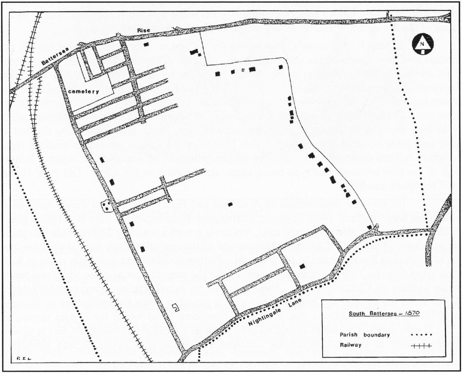
Fig. 6. Sketch-map of the area in 1870.
Note 2. This probably meant that he owned a number of cabs and hired them out to different drivers.
Note 3. In summary, these included services from Victoria and Waterloo, and the Richmond line through Putney. In addition, Clapham Junction handled trains to Sussex, the south-west of England, and to many parts of south and south-east London via the London, Chatham and Dover lines. Trunk routes to the Midlands and North (via Kensington and Willesden) also passed through the station.
Note 4. The name was originally expressed in the possessive form, i.e. Webb’s Road, but the use of the apostrophe has never been consistent. Even the original blue-enamel street nameplates that can still be seen today contradict the early-twentieth-century cast-iron versions.
Note 5. Like Webbs Road, the use of an apostrophe in Stonells Road has never been consistent. Dents Road has never had an apostrophe.
church, named St Mark’s, it is said, so that the inscription on the school could most easily be altered, was to be a chapel of ease to St Mary’s. The iron building remained in use until the consecration of the permanent church building in September 1874. The school building meanwhile proved to have other uses, the Battersea Vestry removing itself there from the Lammas Hall in 1868. Holding its first meeting at the new venue on 7 July 1868, a resolution was passed ‘that the thanks of this Vestry are eminently due and hereby given to the Vicar [Rev. John Simon Jenkinson] and Mr Cazenove [see above] for their kindness in allowing the occasional use of the school room for meetings of the Vestry’
The final estate development to be approved in this decade came late in 1868 when James Wylson, on behalf of the Conservative Land Society (CLS), submitted proposals for several new roads on Henry Wheeler’s Bolingbroke Park Estate. It is worth reminding ourselves of the view expressed by the Vestry in 1859: ‘The Vestry have heard that the remainder of the land has been contracted to be sold for building purposes.’ Since that time in fact, only Auckland and Middleton Roads had appeared. The names of the new roads were settled during 1869. These were Salcott, Bennerley, Mallinson, Shelgate, Cairns, Abyssinia, and Northcote Roads. Alternatives mentioned included the names of men associated with the CLS, Manners and Wylson, and Bolingbroke Road. Although the names varied, the actual layout of the roads is as originally proposed, extending ‘from the Tooting Lane [Bolingbroke Grove], to the lane [Webbs Road], forming the eastern boundary of the Estate’ Thus the road pattern of this part of South Battersea was established, remaining intact until the closure of Abyssinia Road in 1977
Although that pattern is as originally laid out, the content has changed over the years. The roads off Northcote have always been residential in character, whilst Northcote Road has developed as an extended shopping parade. It does not appear that this was an intention on the part of the CLS, most of the early applications for buildings being domestic in nature. Shops were built however, and these eventually became predominant. Before that the Battersea Rise parade created by Christopher Todd on his Auckland Road development was flourishing, and by the end of the 1860s it included two grocers, a greengrocer, butcher, tailor, tobacconist/stationer, fishmonger, chemist, draper and a coffee house. It was perhaps the success of this trading area that encouraged retailers to set up business during the 1870s in the broad, 50-foot ‘carriage road’ called the Northcote. The sketch map of 1870 (fig. 6) illustrates the stage of development then attained.
During the greater part of this decade consolidation of previously approved developments was the keynote. Only a few additional roads were sanctioned, one in 1872, five in 1875, then no more until 1878. The period ended with the largest development receiving approval in 1880. By then the population of Battersea was increasing dramatically, but in 1871 it was still only 54,016. A relatively small proportion of this number were South Battersea residents, the growth of the area lagging behind more northern parts of the parish. The few were not reticent about letting the District Board know of their existence however, writing in about the unsatisfactory state of roads and the lack of facilities such as street lamps. Complaints about the piggeries, slaughter houses and cow-keepers were common. Indeed, the environment of Chatham Road appears to have enjoyed all of the latter; it is difficult today to imagine quite what the road must have been like in the mid-Victorian period.
The activity of local people did not confine itself to letter-writing. One of the pioneer ‘action groups’ came into being in 1870 to make representations concerning the use of Wandsworth Common. Under the guidance of Sir Henry Peek of Wimbledon Common fame, a fund was started to finance a lawsuit against the Lord of the Manor, Earl Spencer, to determine the rights of commoners. In the event, conditions for use similar to those agreed for Wimbledon Common were adopted. Under the Wandsworth Common Act of 1871, the common was assigned to conservators elected by the ratepayers, in consideration of £250 secured to Earl Spencer on the rates, based on his average income from the sale of gravel. This arrangement lasted until 1887 when it was superseded by the MBW obtaining legislative powers for relieving the parish of the charge, and vesting control of the common in the MBW itself. This function was assumed by the Metropolitan Board’s successor, the LCC, and its replacement, the GLC, and then completing the circle, responsibility was handed over to Wandsworth Council in 1971.
By the time of the 1871 Act however, parts of the common were already enclosed, and it was upon one of those portions that Christopher Todd proposed to lay out a new road, near to St Mary’s Cemetery. Approval was given in early 1872, and Mabel Road, subsequently renamed Chivalry Road, came into being. Buckmaster, who was closely involved with the Wandsworth Common preservation activities, had tried to prevent the fencing off of the land where Chivalry Road was formed. However, in 1872 he broke new ground by suggesting that the WDBW should make efforts to improve the amenities of the area by planting trees along the roads and on waste pieces of land. Initially his ideas were well received but for one reason or another they were never implemented. On the common however, oak seats were provided, but then as now vandals did their worst. One was caught and prosecuted in June 1872, his captor, a police constable, receiving a £2 reward.
In the same year as these diverse activities were taking place, the Rev. Henry Boutflower Verdon, then curate at St James’s, Clapham, was appointed to take charge of the Chatham Road district of the parish of St. Mary’s, Battersea. A need was felt to exist there for a place in which meetings for services might be held, and for a school for younger children. After difficulties in obtaining the site, a service to mark the construction of an iron building took place on 8 August 1872. St Michael’s, as it was named, was situated near the top of the west end of Chatham Road. The day school was for girls and infants, being run at first by a Mrs Watson. Opening on 12 August 1872 with fifty-five children, it quickly doubled its number of pupils. Church services started in December in the schoolroom and a lending library was opened in the Church House, Bolingbroke Grove. The Rev. H. B. Verdon was by this time resident in Auckland Road, assuming his pastoral duties at St Michael’s.
Across Battersea Rise from Auckland Road, the temporary iron church building erected in 1868 was still in use. Indeed there appears to have been no progress made towards the construction of a permanent building until after the arrival of Rev. John Erskine Clarke to take charge of the parish of Battersea (fig. 7). He was inducted on 2 February 1872 but it was not until 1873 that he applied himself to the inconvenience caused by overcrowding in the iron church of St Mark’s. At this time a committee for building a permanent church was formed, with himself and Philip Cazenove as joint secretaries. The committee obtained designs for a building from William White FSA, and, having settled the architectural details, engaged Messrs T. Gregory, a firm of local builders, as the contractors. On 11 November 1873 the corner stone of the new building was laid; inside it were some coins and a bottle containing a parchment record of the circumstances of the building of the new church. Under the stone was an oak box in which were placed a bible and a book of common prayer.
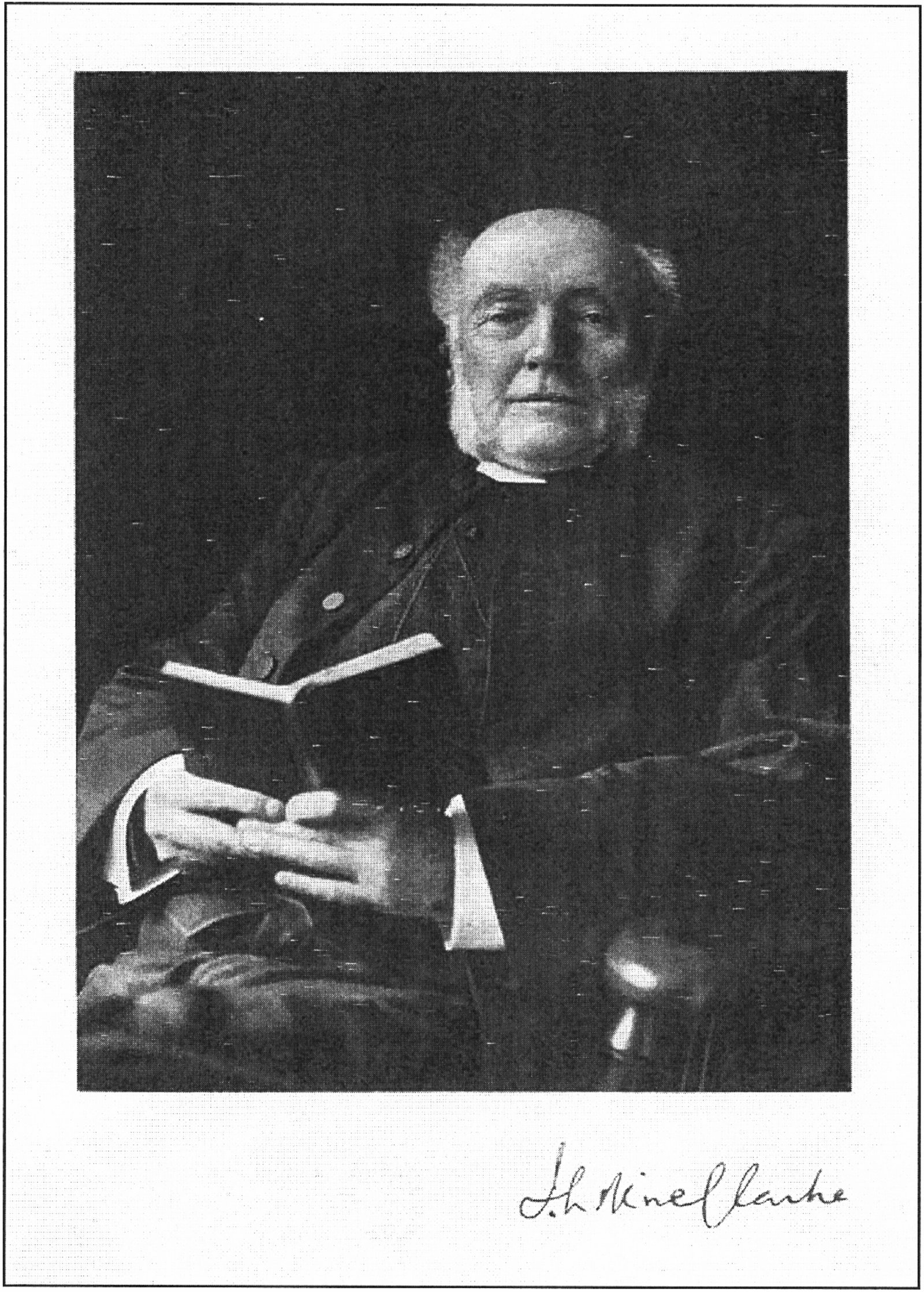
Fig. 7. Signed photograph of the Rev. John Erskine Clarke, Vicar of St Mark’s Church, Battersea Rise, c.1890.
Work continued through 1874, although not as quickly as the Building Committee had anticipated, and by September matters were sufficiently advanced to permit the consecration ceremony to be performed (fig. 8 overleaf). On 30 September 1874 the religious part of the ceremony took place, conducted by the Right Rev. Dr Harold Browne, Bishop of Winchester; the civil transactions could however not be carried out due to the non-arrival of vital legal documents. Present at the ceremony was the Rev. Verdon, who, it was by now intended, should become the first vicar of the parish of St Mark’s on its creation. Sadly this was never to come about, since before the parish was formed he died while still young. His contribution to the district is remembered by the name of Boutflower Road, in which St Mark’s is situated. After the consecration of the permanent church building, the iron building was removed to a location near to the parish boundary in Nightingale Lane, where it was dedicated in November 1874 in the name of St Luke.
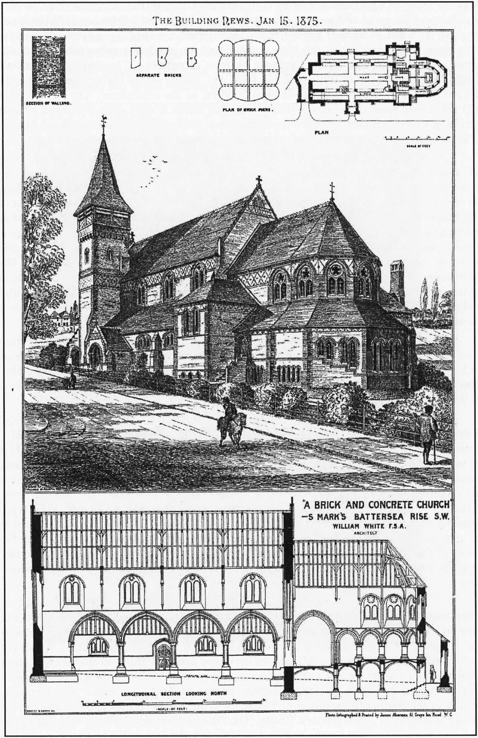
Fig. 8. St Mark’s Church on Battersea Rise, shortly after its completion in 1874.
During 1874 the sanitary conditions of Battersea Cemetery were called into question, as a result of which an enquiry was held into the interments there. This revealed that between the opening of the cemetery on 16 November 1860 and 24 June 1874 the number of burials amounted to 10,595. The outcome of the enquiry was a report to the Home Office and the dismissal of the Cemetery Superintendent.
Christopher W Todd is a name mentioned earlier in connection with the development of Chivalry, Auckland and Middleton Roads. He reappears in October 1874, this time in dispute with the Conservators of Wandsworth Common. There was apparently a tree in Bolingbroke Grove that had in some way caused damage to one of his newly built houses there. In an inspired reply, the Clerk to the Conservators suggested that ‘as the tree had occupied its present position for more than half a century, any damage to the house must be taken to be caused by its having been erected in too close proximity to the tree’ This reply apparently did not satisfy Todd, for soon afterwards the tree was felled by persons unknown! It is clear that the rural aspect of South Battersea still existed at the end of 1874, since the records of that year mention not only the dairies and piggeries in the area, but also the fact that goats were being kept rather too close to Salcott Road for some of the new residents’ liking.
A number of proposals came in late 1875 for new estate developments. The first of these was for part of the estate formerly owned by the Dent family adjacent to Wandsworth Common. That proposal consisted of the intention to construct a road basically as Blenkarne Road is today, but extending along its southern leg as far as Nightingale Lane. In fact the development appears not to have fulfilled the envisaged potential; the road stopped well short of Nightingale Lane, and it was a subsequent development of 1882 that completed the build-up of the area. In September 1875 a further portion of the CLS’s estate was approved, resulting in the southward extension of Northcote Road and the construction of the eastern sections of Belleville and Wakehurst Roads. The third and last development was that of the Clapham Common Gardens Estate, comprising Almeric and Lindore Roads, together with the associated frontage on Battersea Rise. For many years before development, this estate had been the home of the prominent Ashness family.
Not until 1878 were any further roads approved, by which time the transfer of Clapham Common from its management by elected conservators to the control of the MBW had been effected in 1877 The submission of a proposal in April 1878 to lay out the western sections of Belleville and Wakehurst Roads marked the final stage in the development of the CLS’s Bolingbroke Park Estate. The surveyor responsible for this was W C. Poole and he was living at this time in one of the houses built in the eastern section of Belleville Road. From here he would have had a good view of the first board school to be built in South Battersea.
The School Board for London had been constituted under powers contained in the 1870 Elementary Education Act. Early action had been taken to provide schools in the northern part of Battersea where the population was much greater, but it was not until April 1876 that the WDBW had approved the plans for this building. The minutes of the relevant Board meeting refer to the building being between Wakehurst and Bellevue Roads, but nevertheless it was in Belleville Road that construction took place. Work began in 1876, the building contractor being Messrs. Joseph Thompson of Camberwell Green. A plaque dated that year can be seen on the south wall of the school above the infants’ entrance. By 1877 the new school for boys, girls and infants was opened, the direct result of which was the closing of the day school for girls and infants at St Michael’s Church, which had been operating since 1872. However, the headmistress of the church school was not out of a job as she was appointed mistress of the new infants’ school. A Mr Barter was appointed head of the boys, whilst the girls were under the supervision of a Mrs Christopher. The three schools continued to exist separately until the start of the 1974/75 term when the boys and girls were united to form a Junior Mixed school.
It was in late 1877/early 1878 that a certain amount of local controversy arose over the condition of Webbs Lane. The road, it appears, was still a private one and as such the WDBW were under no obligation to maintain it, though requests to pave and light it continued to be received. To the residents’ clamour was added the voice of the new schools’ managers. All of this was to no avail, the District Board relenting not at all. Representations also continued about the condition of the piggeries in the locality, in particular in Chatham Road, where no fewer than nine residents formally complained to the District Board. The Inspector of Nuisances paid a visit to the offending premises, but it was alleged that the day prior to his visit the pigs were removed and the place tidied up. Following his departure, it was claimed, thirty pigs were returned to their home. So the saga continued.
In addition to the presence of the Anglican churches, other denominations began to organise themselves, drawing their congregations from the continuing influx of newcomers to the area. The United Methodists were early starters, their place of worship being in Mallinson Road. In 1877 the chosen site was in use as a stonemason’s yard, and its suitability for development was recognised by two brothers who worked there. They were Methodists of Battersea Park Church and it was at their instigation that the London Mission Committee purchased the site. Services held in the upper part of a house in Bennerley Road were transferred in July 1878 to the newly completed church; the architect of the new building was James Speed. One year earlier a Strict Baptist chapel had been erected in the eastern section of Chatham Road. The congregation for this was drawn from a group that until then had been meeting in a house in Swaby (Northcote) Road.
Since 1878 marks a watershed in the development of South Battersea, it is particularly apposite that a useful local street directory was published in that same year.[6] From its contents it is reasonably easy to gain an impression of the nature of the development to date. Three distinct districts can be identified. In the south, there was the area of Thurleigh, Ramsden and Rusham Roads, where as yet new housing was limited. It was also of a different nature from that of the other South Battersea districts, being of a superior type of dwelling. The arrival of the St Luke’s church building in 1874 does not appear to have been a stimulus to expansion. The second area of development was centred on Chatham and Darley Roads, then still isolated from the other districts. Even here, despite its early start, the roads were by no means fully lined with houses. This district is not dealt with in detail by the street directory, perhaps an indication of the types of occupant. Here temporary church facilities erected in 1872 remained in use, a situation that lasted until the early 1880s.
The third and most important district was that of the Battersea Rise/Bolingbroke Grove/Belleville Road/Webbs Lane block. Here residential side-streets leading to a central spine road were rapidly being filled with houses, whilst the focal road was beginning to take on the appearance of a retailing centre. Two years later a second edition of the street directory was published and a comparison of the details is shown in Annex 3.
With the development of estates came almost invariably the demolition of any property situated on the land to be developed. This included any large house associated with the grounds. In the case of the CLS’s Bolingbroke Park Estate, however, the house situated adjacent to Wandsworth Common was not destroyed. By virtue of the intervention of the Rev. J. Erskine Clarke, Bolingbroke House was saved, to be put to good use as a pay hospital. Under his guiding hand, the hospital came into being in 1879, and along with it the Wandsworth Common Provident Dispensary (fig. 9). The ancient parish of Battersea was by now fragmented into several ecclesiastical districts, and in that same year, the Rev. Erskine Clarke organised it into the Rural Deanery of Battersea, thus ensuring the continuation of the ancient name in parts where it might otherwise have been lost.
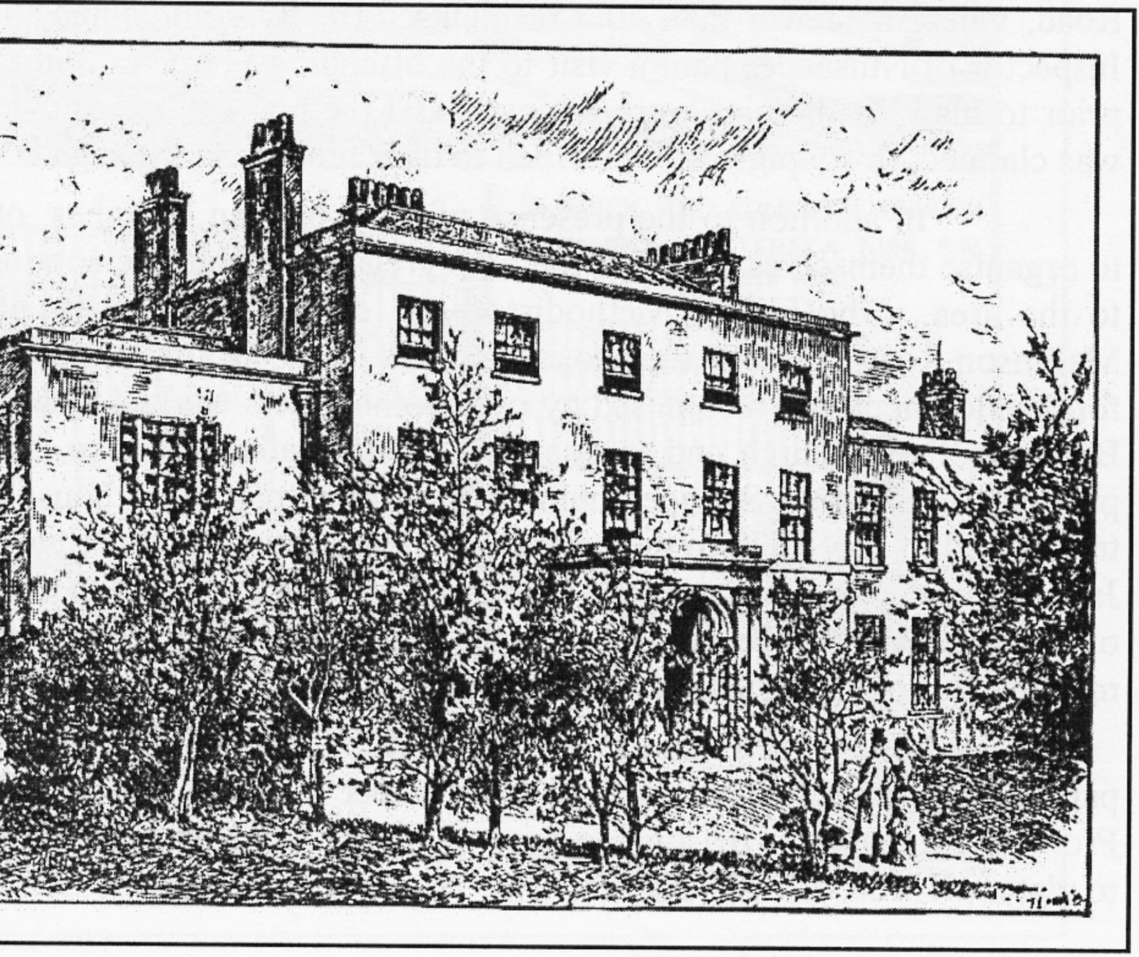
Fig. 9. Bolingbroke Hospital in 1881.
The continued increase in the number of buildings in the area meant that by 1879 the WDBW was able to consider adopting and paving all the roads on the CLS’s Bolingbroke Park Estate and the Clapham Common Gardens Estate. It also agreed to erect two street lamps in that part of Webbs Lane between Battersea Rise and Shelgate Road, and it was as a direct result of this decision that the Bolingbroke Tradesmen’s and Ratepayers’ Association was formed. These local residents were upset by the amount of the apportionments they were required to pay towards the adoption of their roads, and formed a body to oppose the rates. Meetings were initially held at the ‘Invitation’ public house in Auckland Road; in 1888, these were transferred to the ‘Railway Tavern’ on Battersea Rise. Over the years the association became quite a prominent political force in local issues. Many local traders became closely involved in the work of the association, one of these being a Reuben R. Vatcher, another Horace Turnor (fig. 10).
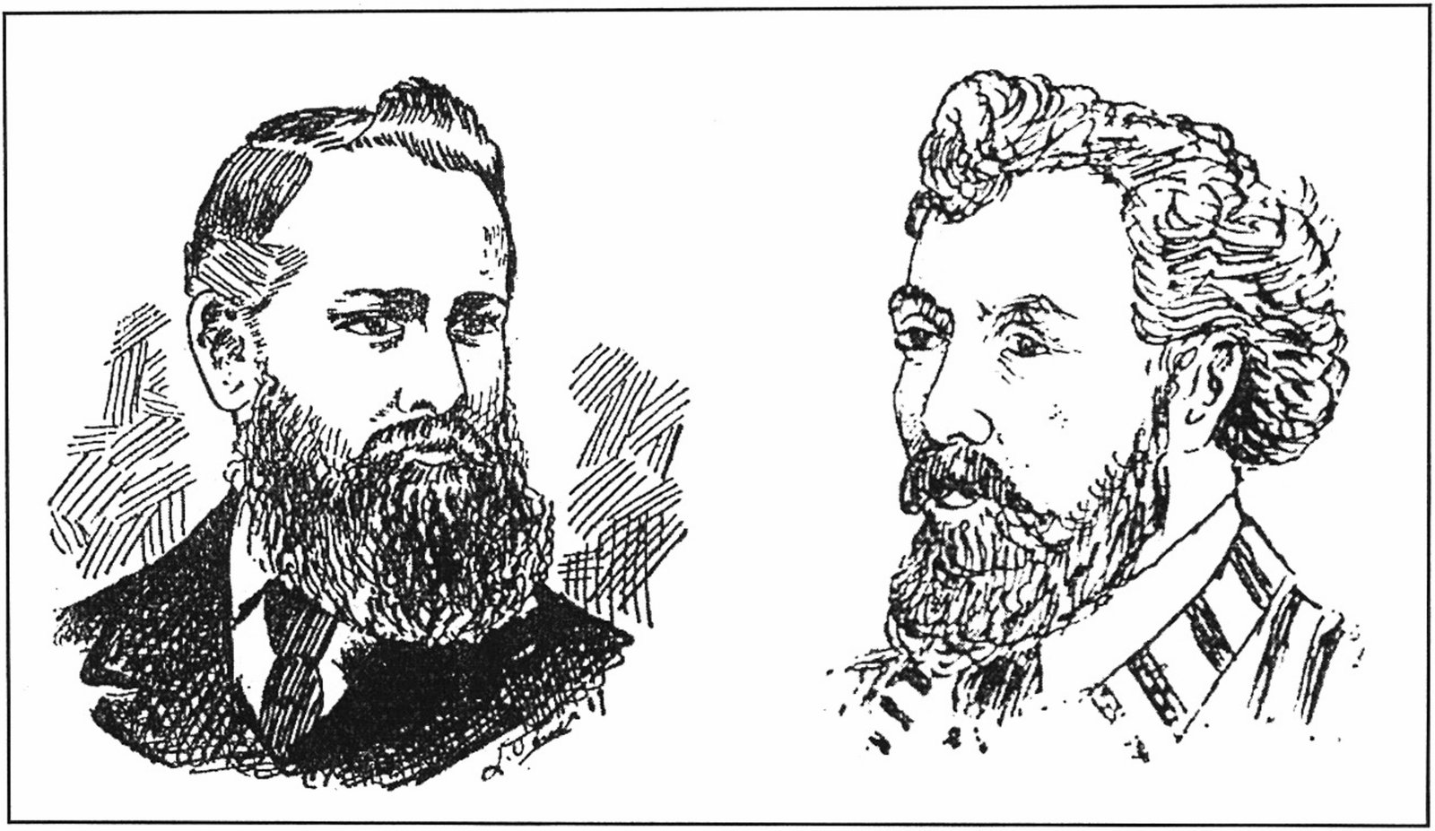
Fig. 10. Reuben R. Vatcher (left) and Horace Turnor, from ‘Clapham Junction and its People: a Peep Show’, published c.1889.
The old year turned into the new on a sad note. In October 1879 the Rev. H. B. Verdon met an untimely end at the age of 33. His death robbed St. Mark’s of the man intended to be its first vicar, and to add to this sad event, the death of Philip Cazenove, one of the Anglican Church’s greatest benefactors in Battersea, occurred in January 1880. Not only had he given financial aid but he had also permitted the use of the grounds behind his house on Clapham Common West Side for church picnics, socials and even as a cricket ground. One positive aspect of the deaths of these two men was the decision to erect as their memorial a permanent church of St Michael’s. Approval for the erection of this was given in late 1880, the building being to the designs of William White, architect of St Mark’s.
In July 1880 approval was given for the largest estate development yet proposed in South Battersea. This was for the Broomwood Park Estate, which abutted the Chatham Road district on the north, and on the south, the Thurleigh Road development, and a scheme for seven new roads plus the extension of two existing ones was agreed. This resulted in the construction of Honeywell, Broomwood, Montholme, Gayville, Devereux, Hillier and Wroughton Roads, as well as extensions to Northcote and Webbs Roads. Naturally enough, the ensuing construction of houses was to take many years before the area was fully developed. Of the two houses on the old estate, ‘The Elms’ was immediately demolished, its site to be crossed by Honeywell Road; the other, ‘Broomwood’, was retained and put to use until being demolished in 1904. Its location is recorded in a plaque on the east wall of the corner house in Wroughton Road, mentioning in addition the fact of William Wilberforce’s earlier connection with the house.
Prior to the agreement of the present road pattern, alternatives were considered. One included terminating Montholme and Gayville Roads before they reached Thurleigh Road, and running a road parallel to Thurleigh Road up to Devereux Road. It was also proposed to extend Swaby Road, now Northcote Road, into a road leading directly to Thurleigh Road. There were even alternative names, Wilberforce being suggested for Broomwood, but none of these came about. Only a few months after this major development was approved an eastward extension was sanctioned, resulting in the formation of those sections of Broomwood and Kyrle Roads bounded by Wroughton Road and the short stretch of link road where Broomwood Road Methodist Church is situated. Fig. 11 depicts the development approved up to this time.
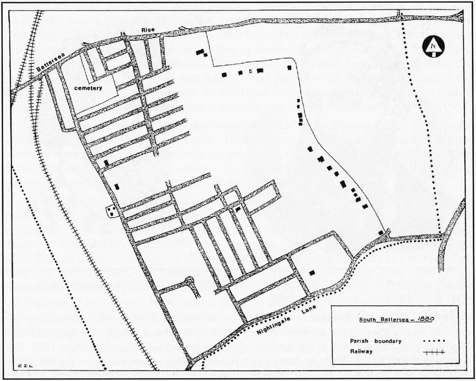
Fig. 11. Sketch-map of the area in 1880.
On reaching the 1880s, it becomes possible to discern a peak period of housing development in South Battersea. Applications for the construction of batches of houses become more commonplace. For example on the Broomwood Park Estate, approval for twenty-seven houses was given in January 1881 to W H. Steer. Then in the June a total of forty-four from the Working Man’s Co-operative Housing Society was approved. The increase in houses reflected another increase, that of the population of Battersea as a whole. There were now 107,199 people in Battersea, an increase on the 1871 figure of 98 per cent. Even now however, less than half the area of South Battersea was built up.
A further move towards that end came in August 1881 when Dent’s House Estate was approved for development. This consisted of the U-shaped road layout to be found today adjacent to Wandsworth Common, comprising Dents and Gorst Roads. Originally it was all called Dents Road, the name Gorst being given to the southern leg in April 1883. The latter name commemorated Sir John Eldon Gorst, a onetime resident of the Dent’s Estate. By 1884 the development of the roads was completed.
The increase in residents caused by the development of the Broomwood Park Estate enabled those who had previously attempted to have something done about the condition of Webbs Lane to re-apply pressure to the WDBW In February 1882 a petition bearing the names of 323 residents was submitted, drawing attention to the almost impassable conditions of the lane, and stating that the lane was now used by hundreds of children who attended Belleville Road School. There was no path on either side of a considerable portion of it, the petitioners pointed out, and that rendered it extremely dangerous for foot passengers. The District Board agreed that as much of the lane as lay between Battersea Rise and Chatham Road should be paved, the first step toward establishing a safe thoroughfare. It should be remembered that there was still no link along the bottom of the valley between Chatham and Belleville Roads. Clearly this meant that children from the new roads of the Broomwood Park Estate had to approach the school along Webbs Lane or, much longer, by Bolingbroke Grove and Belleville Road.
Once a road had been sufficiently built up, it was a common practice for the houses to be given a rational numbering system, since, as they were put up, they were either given a number almost at random, a name, or nothing at all. Bolingbroke Park was the first estate to be formally renumbered, this taking place in 1882. In June that portion of Dent’s estate where it had been proposed to lay out the southern leg of Blenkarne Road attracted the interest of H. Bragg, who submitted an application to form four new roads. These comprised the road pattern that exists today of Morella, Granard (formally Dalesford), Hendrick (formerly Estcourt), and Thurleigh (formally Roy Road, renamed at the instigation of the Rev. J. Erskine Clarke in February 1887).
Only a few months after the approval of the development of the last portion of Dent’s estate, a proposal was submitted to build on the lands of the extensive West Side Estate, adjacent to Clapham Common. This was in November 1882, just less than one year after the death of the widowed Mrs Webb, whose family had occupied the estate for some forty years. The result was the formation of Wakehurst, Salcott, Bennerley, Mallinson and Shelgate Roads ‘in continuation’, the widening and improvement of Webbs Lane, and the creation of two new roads, Leathwaite and Keildon. The original intention was for the latter to run parallel to Webbs and Leathwaite Roads, linking Shelgate Road with Battersea Rise. Not until 1884 was it re-orientated to the position existing today. At that time Leathwaite Road was extended southwards to Ashness Road, Berber Road being formed to link Wakehurst Road to Ashness Road. In addition to the residential aspect of the development, shopping parades were formed on Battersea Rise and in Webbs Road.
Having noted earlier that the first newcomers were not those likely to have required or used public transport facilities, it should now be noticed that the subsequent developments had created an area whose population relied on good facilities to enable them to reach the City for their work. By now the railway link was a prominent ‘commuter’ amenity, whilst horse-bus services had formed a useful link with the business centre for many years. It is not until the early 1880s that the horse tram appears to have been considered for a route through the area. Intended to run from Clapham, through Battersea to Wandsworth, this particular route was in the event not introduced. An amenity of a different nature, but one mentioned already in this study, is that of street lighting. The WDBW, whilst responsible for providing suitable lamp columns, was not required to supply gas, this being undertaken by one of the several gas companies of the metropolitan area. Difficulties arose over the supply of street lighting on the Broomwood Park Estate, as the company, in this case the South Metropolitan Gas Company, was not obliged to provide gas to lamps erected more than 75 yards from an already existing lamp. Negotiations resulted in the District Board agreeing to supply extra lamps to fill the vacant gaps, thereby enabling Broomwood and Wroughton Roads to be lit. Elsewhere, it is interesting to note, the Board was considering the advanced notion of introducing electricity as a means of lighting, but this idea was to take several years to become a reality in South Battersea.
Several events of a general nature should be mentioned as having occurred at this time. One was the formal creation of the Anglican parishes of St. Mark’s and St Michael’s, thus isolating the district of St Luke’s to the south from the mother parish of St Mary’s. The second, an associated matter, was the submission in November 1883 of an application for the erection of a permanent church of St Luke’s, on the site it still occupies. A third issue was that of extending Northcote Road through to Nightingale Lane. A proposal to submit a memorial was considered by the WDBW, but after lengthy discussion of the merits of such a move, the proposal was rejected, resulting in the formation of Montholme Road in its offset position from Northcote Road. Lastly as a result of the endeavours of the Endowed Schools Commission, Emanuel School, formerly located in Westminster, moved to ‘the country at Battersea’, where it remains today.
April 1885 was the month in which approval was given for the development of Chatto’s Estate, the property which had been the home until his death in early 1880 of Philip Cazenove who was mentioned earlier. In the year of his death, sanction was granted for the development of the estate by Alfred Heaver but this was not proceeded with, and the house appears to have been in residential occupation until 1885. Roads comprising Chatto’s Estate are Grandison, Burland, Dulka and Chatto.
By the mid-1880s Northcote Road was beginning to show more signs of growth. None of the earliest arrivals has survived, though Richmond’s, a firm of general builders’ merchants at the corner of Shelgate Road, who were operating in the 1970s, could claim descent from Fred. Richmond, a plumber, who was in business by 1885. Another pioneer was J. W Frost, an oil and Italian warehouseman, whose original shop was in the parade between Salcott and Bennerley Roads. Until the mid-1970s, a company of dyers and cleaners, started in 1878, were still in operation at Gothic Villas.[7]
Reflecting the continuing development of the metropolitan area, the formation of the Parliamentary Borough of Battersea and Clapham in 1885 marked an important step. The Borough consisted of two divisions, South Battersea being included with the parish of Clapham under the name of the latter. The first MP for the division was John Fletcher Moulton QC, a Liberal. In the following year a further election was held and Moulton was unseated by John S. Gilliat, Conservative, a member of a local family and himself born in Battersea.
The roads of the West Side Estate, along with the western halves of Honeywell and Broomwood Roads, were adopted and paved in 1886. Webbs Road however continued to be a problem for the WDBW, since the owners of property in the road were unhappy about the rates of apportionment, contesting the right of the Board to make the apportionments on the grounds that Webbs Road was already a parish road. The Board remained adamant and adhered to its decision. A further useful decision was taken in April 1887, when the extension of Wroughton Road southwards to link with Chatto Road was agreed. Just prior to that time, agreement had been obtained to the suggestion of Rev. J. Erskine Clark whereby Thurleigh Road was physically linked to Ray Road, communication throughout the area being greatly facilitated.
Early in 1887 there came the first proposal for the erection of a Baptist chapel at the corner of Northcote Road and Wakehurst Road, this being from W Johnson. Although agreed by the District Board, this scheme was not proceeded with, and in June a further application was submitted, this time in the name of E. W Mountford, a prominent local architect. The new designs were approved in August and construction went ahead, the building being completed during 1889. The external appearance of the building remains much the same today as when built, the major difference being the lack of the slated spire removed in the early 1970s (fig. 12 overleaf).
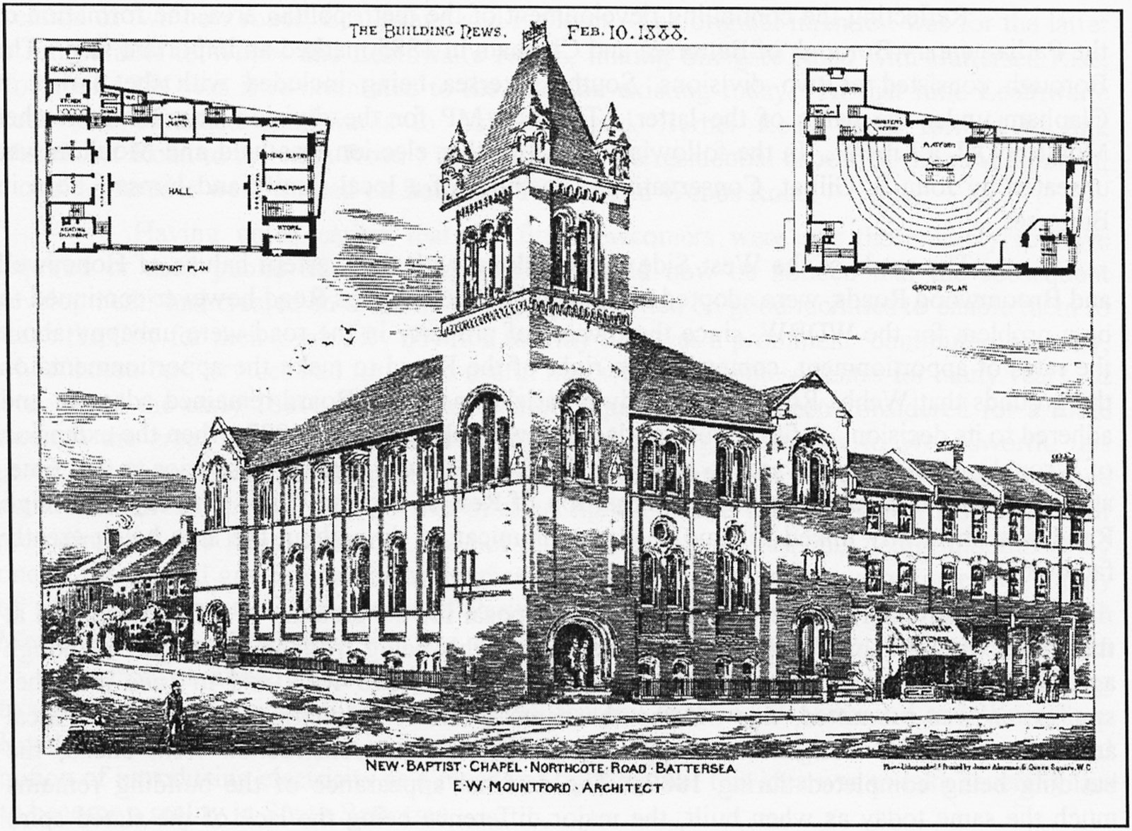
Fig. 12. An artist’s impression of the Northcote Road Baptist Church, published while the building was being erected.
New houses continued to be erected in the recently approved estates, Chatto and West Side in particular. By November 1887 Chatto Road itself was adopted and paved. Earlier in the year, the Royal Assent had been given to the Act of Parliament securing the transfer of management responsibility for Wandsworth Common to the MBW
Perhaps the most important event in Battersea’s communal history was the attainment of ‘home rule’ in 1888. Since 1855 the parish had been within the area administered by the WDBW Under the terms of the Metropolis Management (Battersea and Westminster) Act 1887, it was to become a ‘Schedule A’ parish, that is, with a population of sufficient size to permit it to have its own local government. Thus it was that the Battersea Metropolitan Vestry came into being, holding its first meeting on 26 March 1888. This body, 120 members strong, presided over local matters for the next twelve years until superseded by the Borough Council. Representatives were elected in four wards, the ward for the area under discussion returning twenty-four members. The first road of South Battersea to be considered by the Vestry for development was Old Park Avenue, off Nightingale Lane. The Vestry in fact objected, but the final decision as before lay with the MBW, which body approved its formation. The final houses were not erected until 1900, the two builders of the area being responsible for all those built being R. J. Saker and D. Kettle.
Mention should be made of the names of some of the countless builders by whose endeavours the South Battersea of today was created. Research has revealed the identities of many of those forgotten men of the Victorian era, and it is fitting that they should be recorded in this account. On the original Chatham Road development, the situation was prevalent of a number of builders erecting perhaps one or two single houses. This was followed by the Auckland Road development, which involved a smaller area and consequently fewer builders. The businesses with which Messrs Lane and Gibson, George Randall and James Tanner were associated figure prominently here. On the Bolingbroke Park Estate, many builders played their part, the most prolific being George Collis of Pimlico and Alfred Heaver, later to become an important figure in the wider story of south London Victorian housing development. Also notable are Charles Cooper, responsible for many of the early shops in the Northcote Road, and Joseph Stapleton, who appears to have arrived in South Battersea at the birth of Chatham Road and to have continued his work in the area for at least the next twenty years. The development of the Clapham Common Gardens Estate was an exception to the normal rule, since one man alone, John Miller of Clapham, was associated with the construction of all the houses in Almeric Road. Broomwood Park, the most extensive of all South Battersea estate developments, appears to have been undertaken to some extent to a pre-determined plan, and for that reason the names associated with it recur. John Smith appears to have been the most important of all, others being J. E. Statham, D. Thompson, W H. Steer, W E. Kerven and S. Rashleigh. Later, builders on the West Side Estate and elsewhere in the area included W H. George, Alex Boyce, W Gifford and Abel Playle, all of whom built substantial numbers of properties. These men were the prominent ones, but there were hundreds of other small concerns in Battersea, and it is only since the beginning of the present century that detailed assessments of the exceedingly productive nature of their activities have been published.[8]
The continuing growth in the local population resulted in a need for additional educational facilities. In the latter half of 1888 the Vestry considered the requirement for such facilities in the southern portion of the Northcote Road district. With support from the Bolingbroke Tradesmen’s and Ratepayers’ Association, representations were made to the authorities in October 1888. The following year application was made for the erection of temporary iron buildings in Honeywell Road to be used for schools. Permanent buildings do not appear to have been completed until 1894.
The decade closed with approval being granted in March 1890 for the development of the Rev. John Pincher Faunthorpe’s Estate, which lay between Chatham Road and Wakehurst Road. Here the final section of Northcote Road was laid out, along with Bramfield and Kelmscott Roads. Prior to development, Faunthorpe, who was the Principal of Whitelands College, Chelsea, had been in occupation for a number of years. The southern part of Northcote Road was not thrown open to the public until 1891, whilst the shops built there date from the mid-1890s. With this development, the completely built-up area extended from Battersea Rise to Nightingale Lane, at least along the central and western portion (see fig. 13).
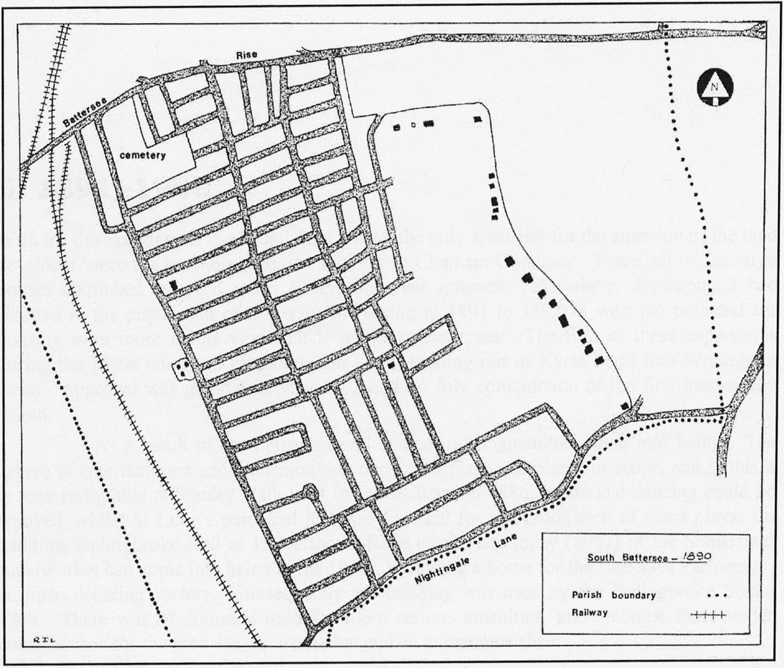
Fig. 13. Sketch-map of the area in 1890.
With the development of the Faunthorpe Estate, the only areas left for the attention of the land developer were the remaining estates adjacent to Clapham Common. There, all of the large houses continued to stand intact along with their grounds. Elsewhere, development had resulted in the population of Battersea increasing in 1891 to 150,048 with the potential for housing even more in the virgin lands of South Battersea. The first of these expansions during the 1890s consisted of Ballingdon Road, running out of Kyrle Road into Wroughton Road. Approval was granted in May 1892 and by July construction of the first houses had begun.
As a result of the housing development, other amenities came into being. The sphere of entertainment and recreation was one where there was plenty of scope, and in this it is noteworthy that at Stanley Hall, built in Cairns Road in 1886, music and dancing could be enjoyed, whilst St Luke’s parochial hall was licensed for the production of stage plays. In addition, Bolingbroke Hall at 15 Northcote Road on the site today (2007) of the Somerfield supermarket had come into being in the 1880s, providing a home for the Battersea Parliament, an open debating society. Subsequently the building was used by the Bolingbroke Social Club. There was of course a need for more serious amenities, and amongst those under consideration for the area were a fire station and an ambulance shed.
Conditions in all the new developments were not however entirely to the satisfaction of the new residents. In particular, inhabitants of that part of Blenkarne Road called Nightingale Park Crescent were experiencing the misfortune of flooding in their back gardens. These backed on to the site of the former Falcon Brook, now a bricked-in culvert. A deputation from the Vestry visited the scene of the flooding and after deliberation decided that it was a problem for the LCC to deal with as the main sewer authority.
Throughout 1892 applications to erect houses continued to arrive at the Vestry Offices, consisting more and more often of large numbers: twenty-eight in Bramfield Road, seventeen in Ballingdon Road, for example. There was the occasional request for smaller numbers, and the general pattern continued throughout 1893 and 1894. In November 1893 the new Town Hall on Lavender Hill was opened and the old offices on Battersea Rise became redundant. One suggestion for their use came from a civil service official who wondered if the premises might be suitable for use as a college. This scheme did not materialise and later in 1894 they were let to a Rev. H. Mackenzie for Sunday services at a rent of 25s per week. Subsequently in May 1895 the property was sold for £500 to Horace Turnor, one of the successful tradesmen of the area.
Not far from the Vestry Offices, bitter scenes throughout the 1890s took place in Northcote and St John’s Roads between shopowners and costermongers.[9] Despite the latter constantly being fined, they continued their illegal practice until after the turn of the twentieth century, when a permanent home was established for them in Northcote Road. Fights too were common outside the Bolingbroke Hall, a situation that was not pleasing to the Bolingbroke Tradesmen’s and Ratepayers’ Association. In 1895 two horse-bus services passed through the area. Both terminated at Clapham Junction station; one came from Balham via Chestnut Grove/Endlesham Road/Nightingale Lane/Rusham Road/Thurleigh Road/Montholme Road/Northcote Road. The other went to Tooting via Northcote Road/Broomwood Road/Bolingbroke Grove. According to a report some years later, it appears that omnibuses were practically ‘free to follow any route the proprietors please’, a situation which resulted in the local authority providing granite setts in a road to suit the omnibus traffic, only to find the company abandoning that route and using another road.
Northcote Road was the scene of two proposed municipal ventures during 1895. One was the provision of chalets, or public conveniences. The Vestry came under much pressure, not least from the Tradesmen’s and Ratepayers’ Association, to provide such amenities. It was the LCC that pointed out that if underground chalet facilities were provided as envisaged, problems could arise whenever the Falcon Brook sewer was in flood, as the level of the sewer water could be higher than the chalet drainage system. After due consideration the Vestry abandoned the idea, although it is one that came up again from time to time. The other proposal, which did mature, was the provision of a street-cleaning and refuse depot for the Vestry’s ‘No. 4 Ward’ Suitable premises were found to exist behind the shopping frontage of nos. 19-31 Northcote Road, and these were acquired from T J. George in July 1895 at a cost of £1,000. Wandsworth Council still uses the site as its Northcote Depot.
In October 1897 another of the large houses adjacent to Clapham Common was demolished, this being ‘The Grange’, once the home of Christopher Baldwin who was mentioned in the Introduction. On the estate Amner and Broxash Roads were laid out, together with Clapham Common West Side and a continuation of Kyrle Road. Consequent to this development it was decided to incorporate the southern section of Amner Road with
Note 6. A Directory for Battersea Rise, Clapham and Wandsworth Commons was published by J. Strong of 21 Abyssinia Road in April 1878. A revised edition appeared in August 1880.
Note 7. Gothic Villas was the original name of the distinctive building just north of Shelgate Road on the west side of Northcote Road.
Note 8. For further information on the development of building estates right across Battersea, see Keith Bailey, ‘From Village to Suburb’ in Patrick Loobey (ed.), Battersea past (2002), pp. 26-39. See also Keith Bailey, House Building and Builders in Wandsworth c1850-1915 (WHS Wandsworth Paper 13, 2005).
Note 9. The prevailing view amongst most shopkeepers at the time was that street-trading activity lowered the respectability of an area, thereby discouraging the regular custom of more affluent shoppers.
Ballingdon Road and rename it Roseneath Road in the belief that one day it would be extended as far as the common. In July the following year the house and estate known as ‘Beechwood’ became a development site, making way for Culmstock and Winsham Streets, along with an extension of Clapham Common West Side. Winsham Street was renamed Winsham Grove in 1902. The houses on this estate were constructed in the main by one builder, W H. George. As mentioned earlier, William Wilberforce’s onetime home, ‘Broomwood’, resisted the trend and survived until 1904 (fig. 14).
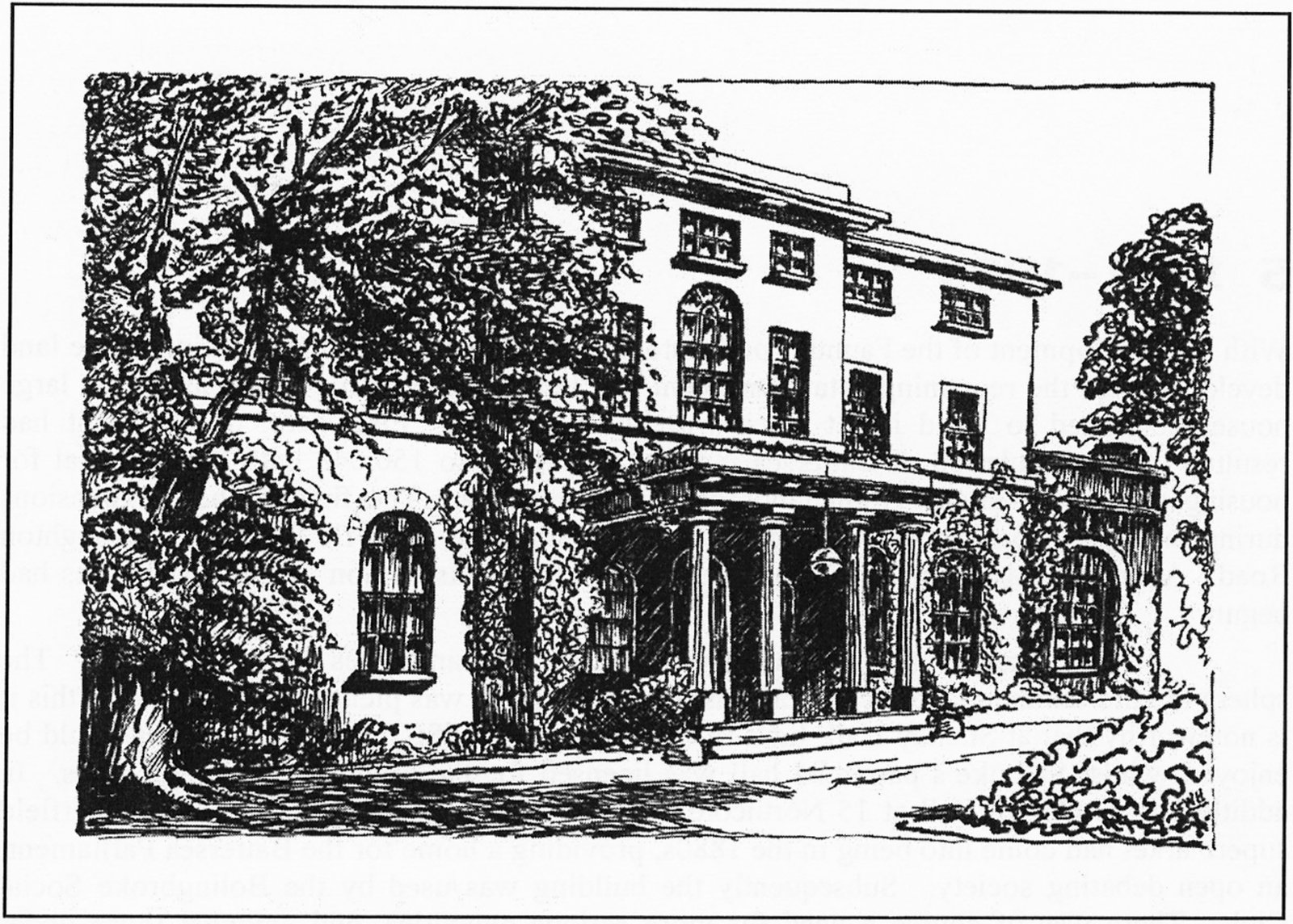
Fig. 14. A pen-and-ink sketch of ‘Broomwood House’, shortly before it was demolished in 1904.
The first flats to be specifically mentioned as being constructed in the area were approved by the Vestry in May 1899. These were approved in the name of T Driscoll, and consisted of six blocks to be erected in Thurleigh and Sudbrooke Roads. To the east of those, David Kettle was proceeding steadily with the building of several semi-detached villas in Old Park Avenue, completing the work in 1900.
Approval for the erection of the permanent Broomwood Road Methodist Church and schools was granted to Messrs Holloway Bros in June 1899. This particular group had originally met in a house in Swaby Road in 1885, subsequently using a converted shop in the same road, moving in 1891 to the Strict Baptist chapel building in Chatham Road. After this an iron building was erected in Swaby Road, this being used until the opening of the permanent building in Broomwood Road. Originally in the Wandsworth Circuit, with the construction of the new building it was transferred to the Clapham Circuit.
The end of the nineteenth century saw much of the present-day housing still being erected, in roads such as Broxash, Amner, Kyrle, Culmstock and Winsham Streets (fig. 15).
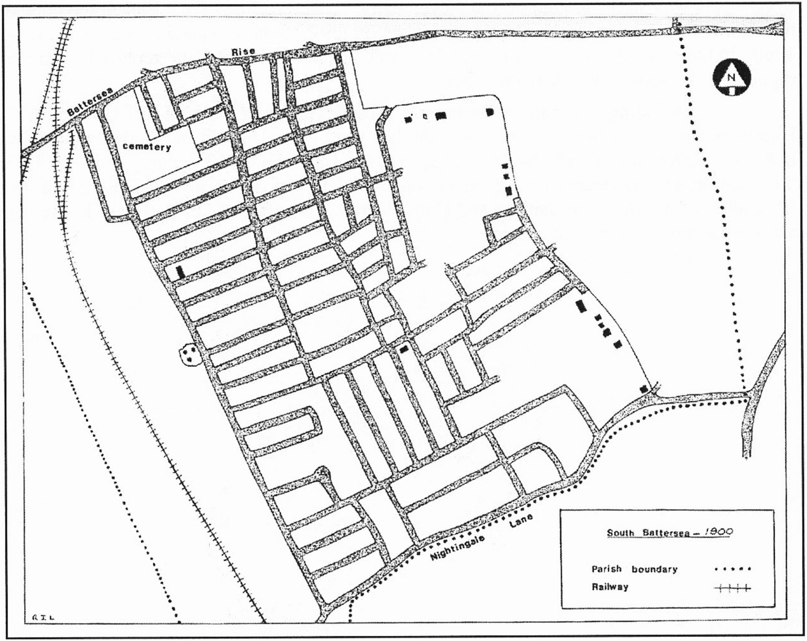
Fig. 15. Sketch-map of the area in 1900.
For reference, Annex 4 provides a summary of the dates when all of the various street names in the area were granted approval. The Victorian era was drawing to a close, leaving its testimony to the capitalists and craftsmen, the builders and Board members, each of whom had played some part in the formation of the urban South Battersea then in existence. This account of the development of the area has provided some insight into the events of fifty years on the local scene. There is, nevertheless, plenty of scope for research in greater detail, the results of which could enhance our knowledge of the transition of South Battersea from a rural to an urban environment.
Although the remainder of the roads and houses in existence today did not arrive on the scene until after the close of the period covered by this account, it may be of interest to give a brief statement of their development.
In August 1901 Manchuria Road, with West Side, was approved. Two years later, in April 1903, sanction was given for the creation of Sumburgh Road and the extension of Thurleigh Road to West Side. By far the largest remaining estate not yet developed was Battersea Rise House on West Side. In 1907 the property came up for sale, was brought by Edwin Evans, a local estate agent, and subsequently developed, the first road being approved the following year. A few years later, in 1912, permission was granted for the eastward continuation of Roseneath Road in conjunction with a temporary road linking it to Thurleigh Road. This was on the assumption that eventually Roseneath Road would reach the common but this it was never to do, the Marianne Thornton Girls’ School replacing the old houses in 1960. In their turn, the school buildings have since been demolished and replaced by modern replicas of the surrounding housing stock.
Excluding that part of West Side constructed when the block of flats known as Hightrees House was built in the 1930s, the last road to be laid out in South Battersea was Holmside Road, this taking place in 1926. Thus it was that almost seventy-five years after urbanisation had commenced the process was complete. In the decades that have followed, re-development due to war damage and slum-clearance programmes in Battersea has brought about a second generation of housing.
All sources may be consulted at the Wandsworth Local History Service at Battersea Library.
| Owner | Occupier |
|---|---|
| Henry Willis | Robert Davis |
| Henry Willis | Elizabeth Champion |
| Elizabeth Hoper | Elizabeth Hoper |
| John Deacon | Alexander Gordon |
| Mary Dent | Mary Dent |
Source: Battersea Poor Rate Book.
| Owner | Occupier |
|---|---|
| John Collyer (2 houses) | John Collyer |
| James Havard | James Havard |
| Lewis Godfrey | Lewis Godfrey |
| Thomas Godfrey Jr | Unoccupied (2 plots of land) |
| Francis Newman (2 houses) | Francis Newman |
| Charles Dungate (4 houses) | Charles Dungate |
| Thomas Godfrey | Thomas Godfrey |
| Reuben Godfrey | Reuben Godfrey |
| – | Thomas Stapleton (beer-house) |
Source: Battersea Poor Rate Book.
| Road name | Occupied dwellings 1878 | Occupied dwellings 1880 |
|---|---|---|
| Abyssinia | 21 | 23 |
| Almeric | 3 | 27 |
| Auckland | 35 | 29 |
| Battersea Rise | 47 | 59 |
| Belleville | 24 | 51 |
| Bennerley | 55 | 66 |
| Bolingbroke Grove | 23 | 36 |
| Cairns | 16 | 16 |
| Chivalry | 6 | 15 |
| Clapham Common West Side | 22 | 20 |
| Lindore | 13 | 27 |
| Mallinson | 44 | 80 |
| Middleton (Buckmaster) | 36 | 31 |
| Nightingale Lane | 20 | 20 |
| Northcote | 41 | 87 |
| Rusham | 3 | 4 |
| Salcott | 39 | 61 |
| Shelgate | 32 | 36 |
| Sudbrooke | – | 2 |
| Thurleigh | 2 | 2 |
| Wakehurst | 11 | 50 |
| Totals | 493 | 742 |
Source: J. Strong’s Directories of 1878 and 1880.
| Name | MBW/LCC approval | Name | MBW/LCC approval |
|---|---|---|---|
| Chatham Road | – | Dents Road | 1881 |
| Auckland Road | 1863 | Gorst Road | 1881 |
| Middleton Road (R1) | 1863 | Morella Road | 1882 |
| Pelling Road (NLO) | 1863 | Estcourt Road (R5) | 1882 |
| Darley Road | 1866 | Roy Road (R6) | 1882 |
| Swaby Road (R2) | 1866 | Dalesford Road (R7) | 1882 |
| Skeldon Road (NLO) | 1866 | Wakehurst Road (c) | 1882 |
| Thurleigh Road | 1866 | Salcott Road (c) | 1882 |
| Sudbrooke Road | 1866 | Bennerley Road (c) | 1882 |
| Westerdale Road (R3) | 1866 | Mallinson Road (c) | 1882 |
| Winchelsea Road (R4) | 1866 | Shelgate Road (c) | 1882 |
| Abyssinia Road | 1869 | Keildon Road (NLO) | 1882 |
| Cairns Road | 1869 | Leathwaite Road | 1882 |
| Wylson Road (*a) | 1869 | Webbs Road (c) | 1882 |
| Manners Road (*b) | 1869 | Berber Road | 1884 |
| Shelgate Road (*a) | 1869 | Leathwaite Road (R8) | 1884 |
| Mallinson Road (*b) | 1869 | Keildon Road | 1884 |
| Bennerley Road | 1869 | Chatto Road | 1885 |
| Salcott Road | 1869 | Dulka Road | 1885 |
| Northcote Road | 1869 | Burland Road | 1885 |
| Belleville Road | 1875 | Grandison Road | 1885 |
| Wakehurst Road | 1875 | Wakehurst Road (c) | 1885 |
| Almeric Road | 1875 | Leathwaite Road (c) | 1885 |
| Lindore Road | 1875 | Wroughton Road (c) | 1887 |
| Blenkarne Road | 1875 | Old Park Avenue | 1888 |
| Belleville Road (c) | 1878 | Bramfield Road | 1890 |
| Wakehurst Road (c) | 1878 | Kelmscott Road | 1890 |
| Devereux Road | 1880 | Northcote Road | 1890 |
| Gayville Road | 1880 | Ballingdon Road | 1892 |
| Hillier Road | 1880 | Broomwood Road (c) | 1894 |
| Honeywell Road | 1880 | Amner Road | 1897 |
| Montholme Road | 1880 | Broxash Road | 1897 |
| Broomwood Road (and c) | 1880 | Clapham Common West Side | 1897 |
| Wroughton Road | 1880 | Culmstock Street | 1898 |
| Swaby Road (c) | 1880 | Winsham Street | 1898 |
| Webbs Lane (c) | 1880 | Clapham Common West Side | 1898 |
| Kyrle Road | 1880 |
Explanatory Notes for Annex 4
| Abbreviation | Explanation |
|---|---|
| NLO | Not laid out |
| R1 | Renamed Buckmaster Road |
| R2 | Renamed Northcote Road |
| R3 | Renamed Ramsden Road |
| R4 | Renamed Rusham Road |
| R5 | Renamed Hendrick Avenue |
| R6 | Renamed Thurleigh Road |
| R7 | Renamed Granard Road |
| R8 | Renamed Ashness Road |
| *a | The same road, the former name not officially approved |
| *b | The same road, the former name not officially approved |
| (c) | Continuation of original road |
Sources: Minutes of the Wandsworth District Board of Works, the Metropolitan Board of Works and the London County Council.
[PB: For reasons of historical completeness, I have left the original prices and contact details, though of course they no longer apply!]
Wandsworth Papers
Wandsworth Historian
Every issue from no. 1. Prices and postage vary.
Other publications
Dorian Gerhold and Michael Bull (compilers), William Field’s photographs of Putney (1997) – £10.50 plus £1.30 postage.
Dorian Gerhold, Local and family history resources for the Borough of Wandsworth (2nd edition, 2004) – £2 plus 60p postage.
John Corris’s map of Wandsworth in 1787 – £3. Available only at Wandsworth Museum.
Stanford’s map of south-west London in 1862; north part and south part – £4 each plus 50p postage for one, 60p postage for both.
WHS Local History Publications 1955-2006: an Index for Researchers – £1 plus 60p postage.
Available from Hilary Sims, 112 Putney Bridge Road, London SW18 1NJ
From scattered Georgian mansions to acres of Victorian housing development, the evolution of South Battersea is a classic example of the rise of the London suburb. Fully researched and highly readable, this informative study is an essential starting-point for anyone wishing to find out more about the history of the numerous houses in the area around Northcote Road.
Roger Logan grew up in South Battersea and worked for nearly thirty years in the Technical Services Department of Wandsworth Borough Council, first as an administrative officer and later as a finance officer. Between 1978 and 1983 he was the editor of the Wandsworth Historian, the journal of the Wandsworth Historical Society, and in 2004 he was awarded a PhD from Kingston University for his research into ‘The Role of Friendly Society Orders in British Society, 1793-1911’ He now lives on the Isle of Wight and is actively involved in the creation in Southampton of a museum and archive for the Foresters Heritage Trust, an independent registered charity, promoting awareness of the history of friendly societies.
ISBN 978 0 905121 18 5