A HISTORY OF
WANDSWORTH COMMON
Added
IN PROGRESS — NOT FOR PUBLICATION
The Black Sea

(Click on image to enlarge)
Hello, my name's Philip Boys. I sometimes masquerade as HistoryBoys.
I research just about anything I can find on the long history of Wandsworth Common. Every month I publish some of the findings as Chronicles of Wandsworth Common.
Tonight I'll be talking about the Black Sea, that once flourished in the north-west of the Common, in the angle between North Side and the London-South-Western Railway.
It's part of a bigger project - that I think of as on the lines of an Anatomy, Physiology and Evolution of Wandsworth Common considered a kind of complex living organism that changes over time.
And to see that organism in relation to its wider ecosystem of Battersea and Wandsworth, London, England and indeed the world as a whole.
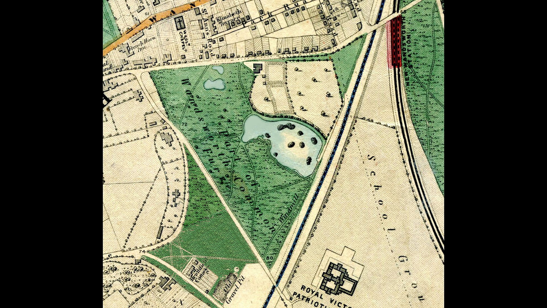
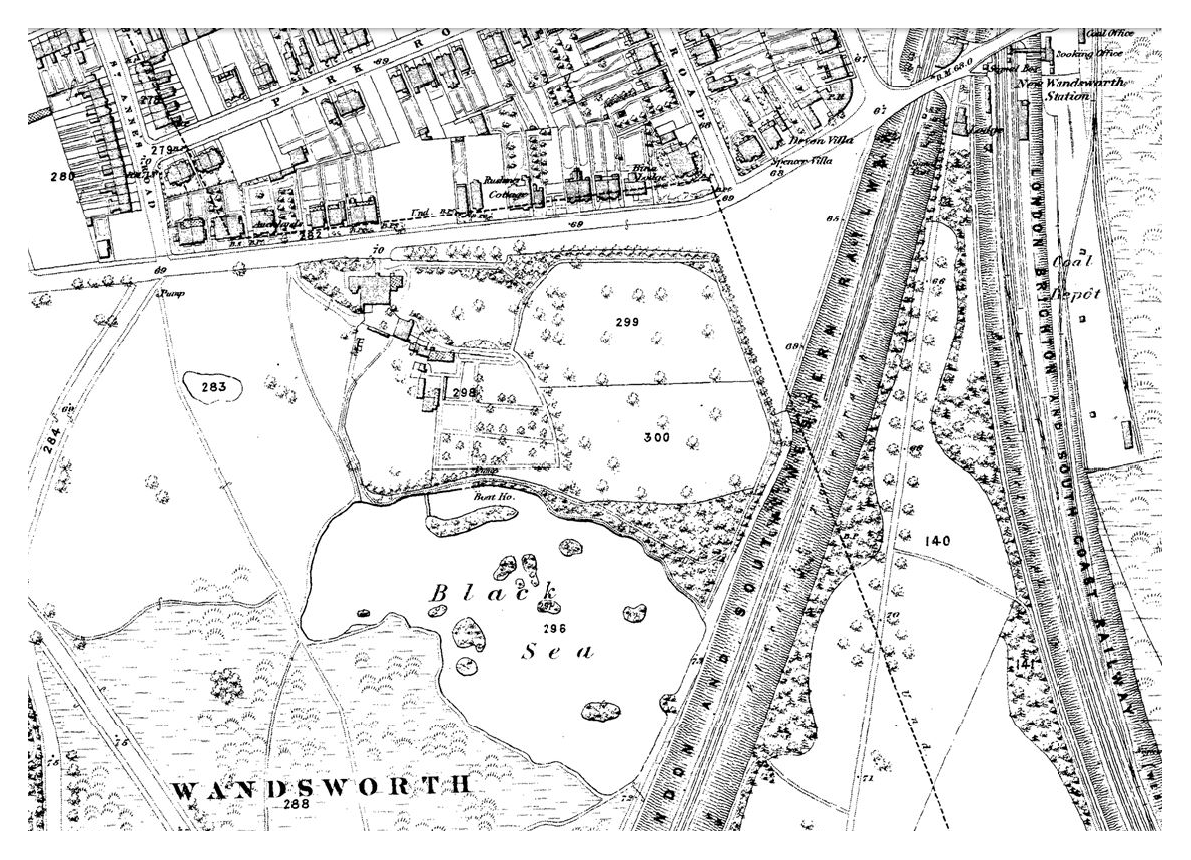
Here is the Black Sea, in a Stanford map of about 1864?
(Click on image to enlarge)
Let's take a minute or two to orientate outselves.
The railway line between London and Southampton, opened in ?
Here's North Side
Trinity Road
West Side
The old "New Wandsworth Station"
Does anybody need some more pointers?
Several things missing
And of course, Trinity Road is much narrower and there's no underpass...
The RVPA's there but no Emanuel School
No Spencer Park
No Earlsfield Road or Windmill Road...
At this time the Black Sea was a well-known beauty spot. But not just a place for strollers, or picnickers, or anglers.
Also for a range naturalists historians - the Black Sea was famous for its rare plants, insects, ? and ?. It features in many specialist listings...
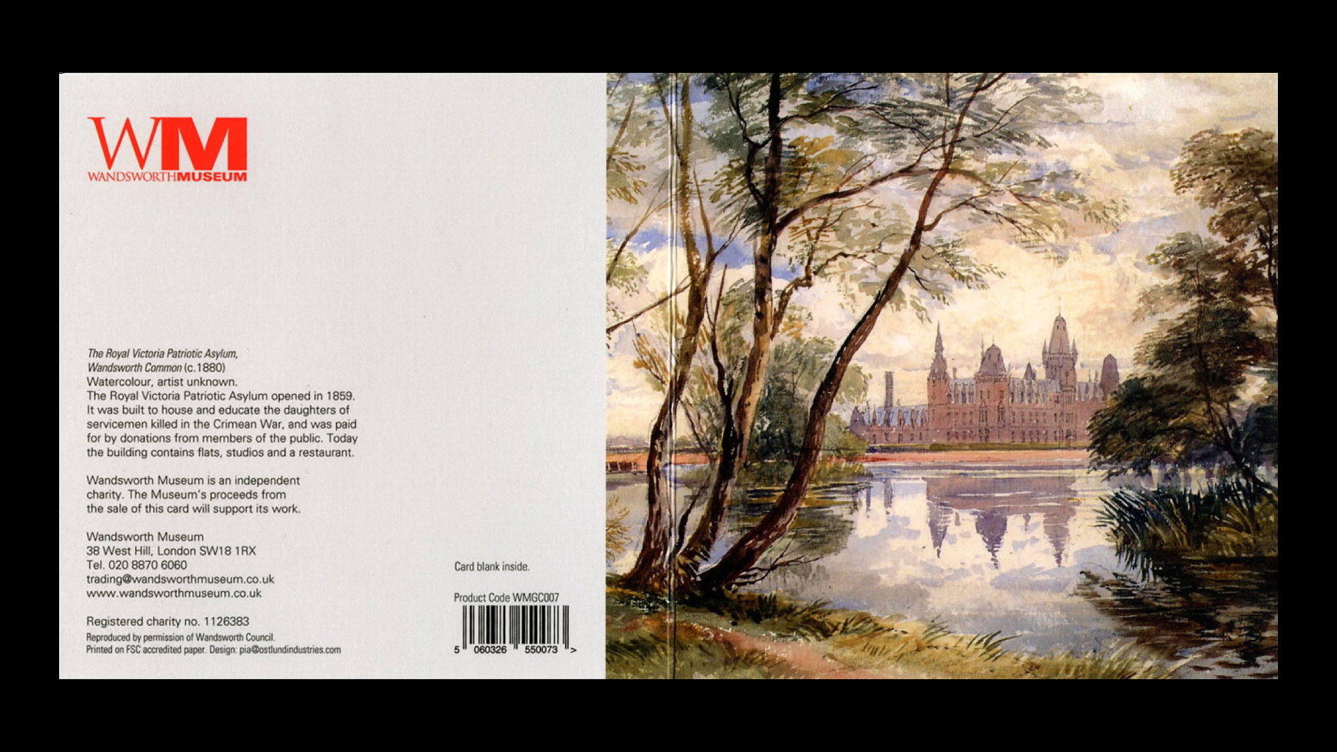
Here's one of my favourite images of the Black Sea, that gives an idea of what it was like in its heyday. [Though it may have been [scheduled for destruction already].]
(Click on image to enlarge)
I first saw this many years ago on a greetings card, published by the Wandsworth Heritage Service.
(Click on image to enlarge)
I've never seen the original, which I assume is safely stored somewhere in the basement at the old West Hill Library - where most of the much-missed Wandsworth Museum is stored.
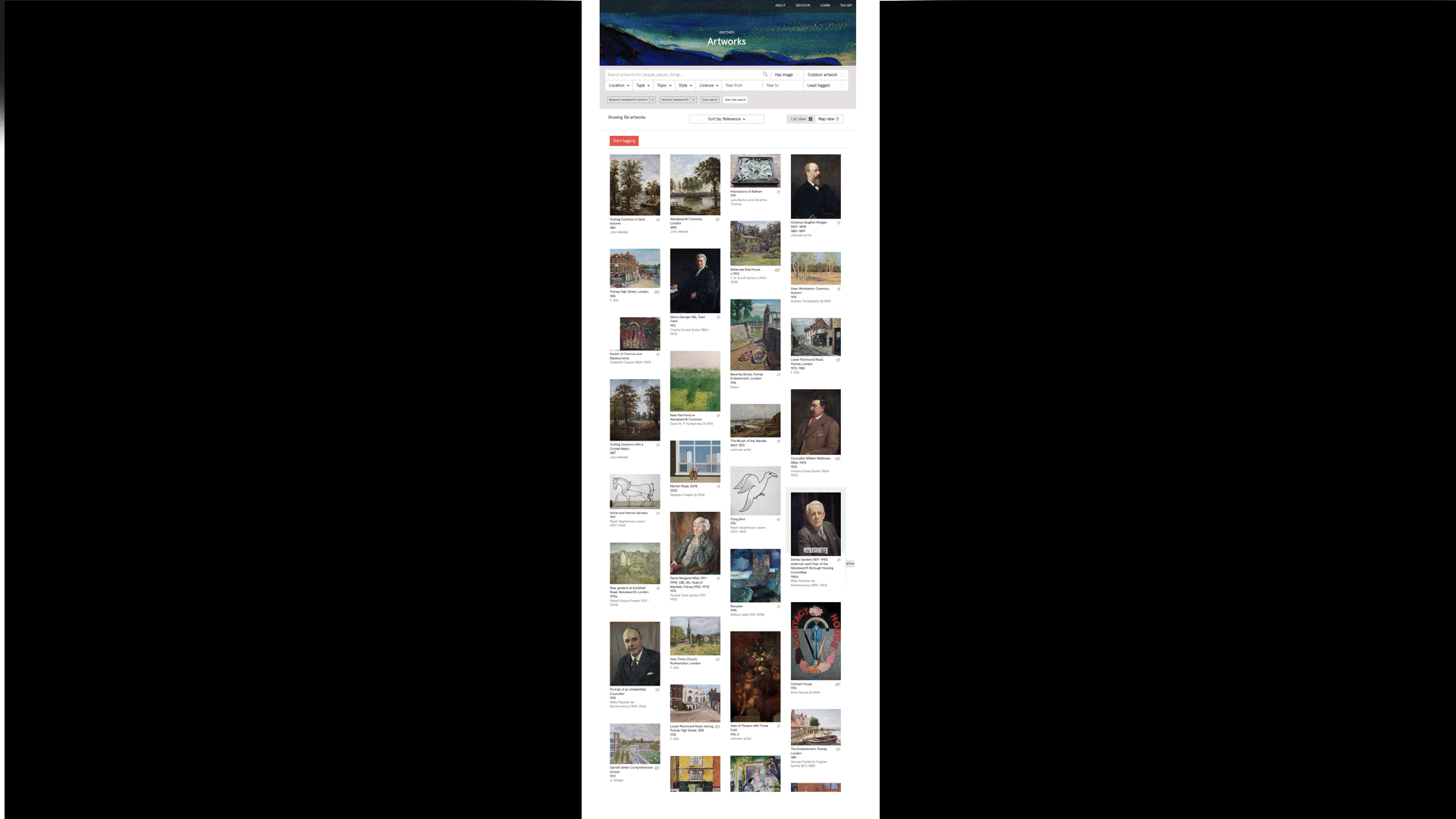
Many of the old images in Wandsworth's collection can be seen on ArtUK website.
(Click on image to enlarge)
But not, alas, this image.
If you don't know the ArtUK website, I strongly recommend it.
www.artuk.org
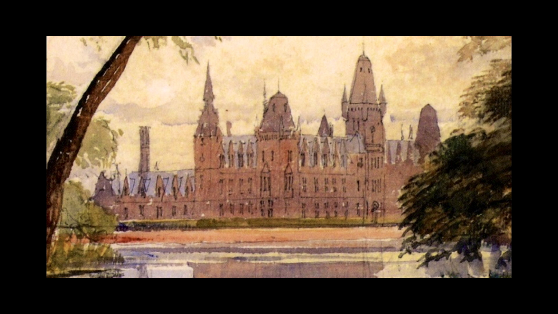
So what are we looking at?
It's a watercolour, and skilfully done (though I don't know by whom).
We appear to be peering out from the bank of a lake, with a small island to our left, partly obscured by a silver birch tree. There are flag irises and dense vegetation on our right, possibly alder trees.
In the foreground, probably a path, and more flourishing vegetation.
In the centre, some way away, quite clearly rendered, is the Royal Victoria Patriotic Asylum for Girls.
The surface of the lake is still, and the bulk of the building, with its many towers and pinacles, are reflected in the water.
There may be some grass, but are no trees around the school.
It was probably still quite young in 1858 [?] - it was built to house orphans whose fathers had been killed in the Crimean War of 1853-6.
It doesn't look like a painting from a photograph to me, though I suppose it might be. It lloks as though it was painted from life.
And we can't know if it is a literal "photographic" depiction. It might have been tweaked.
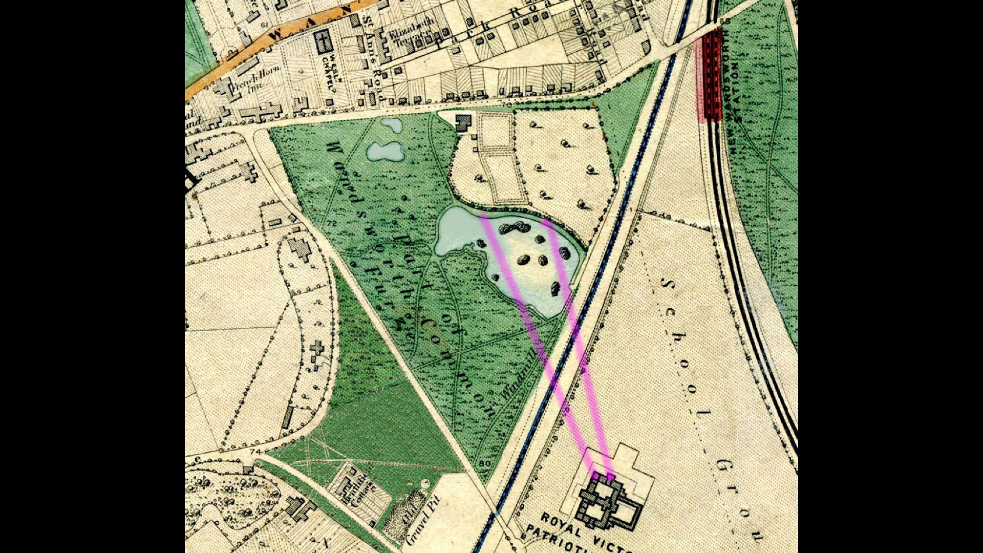
But if we assume this is we appear to be somewhere along the north bank of the lake, possibly from one of these two positions:
(Click on image to enlarge)
Coming in closer:
(Click on image to enlarge)
Frustratingly, there's no windmill to be seen. Did the artist ignore it? Or, more likely, it is obscured by the vegetation on the right.
In any case, as we shall see, it had already lost its sails so it had ceased to pump water.
Notice there are no signs of the railway line that crosses the picture right in front of the Asylum - admittedly in a deep cutting.
Nor of the road - Windmill Road parallel to it. An extension of what is now Earlsfield Road. At this time, neither road had yet been built. There was quite a hoo-hah from Conservators and other local people about the loss of common entailed.
Eventually, the roads were agreed.
We may return to this later.
In the meanwhile, I want to go back to the origins of the lake.
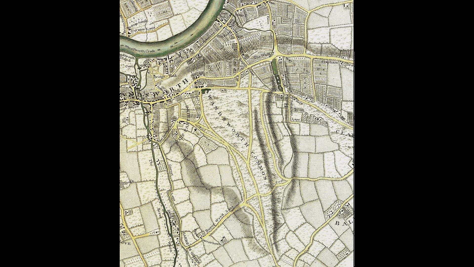
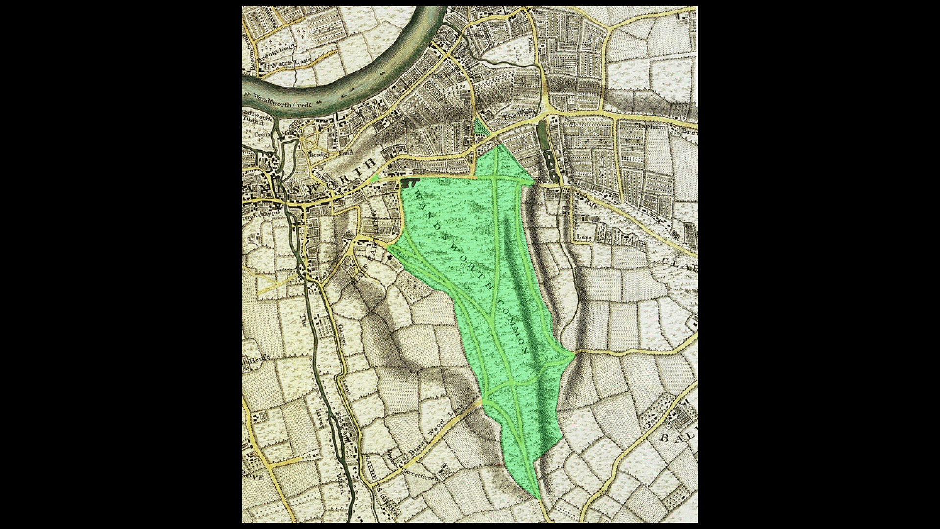
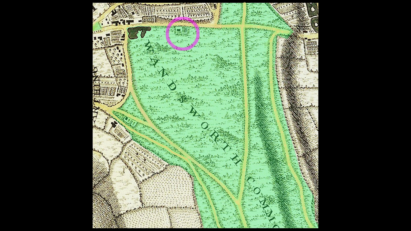
I'd like now to go back in time. Here's the earliest map that I know of of Wandsworth Common as a whole - Rocque's ... of 174? I've tinted the area covered by Wandsworth Common Here's a closeup You can see a house and its grounds - fairly small at this point. But no lake. There is a lake in the area, but it is over here, a few hundred yards to the west. Incidentally it was this lake that caused the otherwise dead straight Trinity Road to vere to the left at the top of East Hill. It looks as though this was filled in and enclosed at more or less the same time as the Black Sea was created.John Rocque's maps of London and its surroundings, from 1740s onwards...
(Click on image to enlarge)
(Click on image to enlarge)
(Click on image to enlarge)
Let's have a quick look at different maps to see when the Balck Sea arises...
Cory's estate maps
date?/ Cory's ? estate maps
(Click on image to enlarge)
1800 / Milne

(Click on image to enlarge)
Milne 1800 [but does Milne ever include lakes?]
But here it is on the earliest OS map, 18??-18??
OS c.1810 / OS
(Click on image to enlarge)
Now we come to the most curious sequence of maps by Cruchley
I've never found any decent high-resolution scans of the Cruchley maps but by using versions online (mainly at auction) I've been able to enlarge and digitally enhance them.
Here's the earliest, from 1828/9
(Click on image to enlarge)
Here's one from ?, with a [red] line denoting the course of the future London and South Western Railway to Woking and Southampton
(Click on image to enlarge)
And here it is again a few years later, presumably after the line has been cut and trains are running.
(Click on image to enlarge)
[Image of Common with line and train]
(Click on image to enlarge)
Tithe map / c1840 / Tithe
(Click on image to enlarge)
dates? / 3 maps by Cruchley
And the coming of the railway...
(Click on image to enlarge)
How many islands? 13? [or 7? or?] - one for every child?
Did the railway cut through Black Sea?
Stops water flowing naturally off the Common, hence a clay lining and a wind pump were necessary...
The Wilsons of Price's Candles / "Black Sea House"?
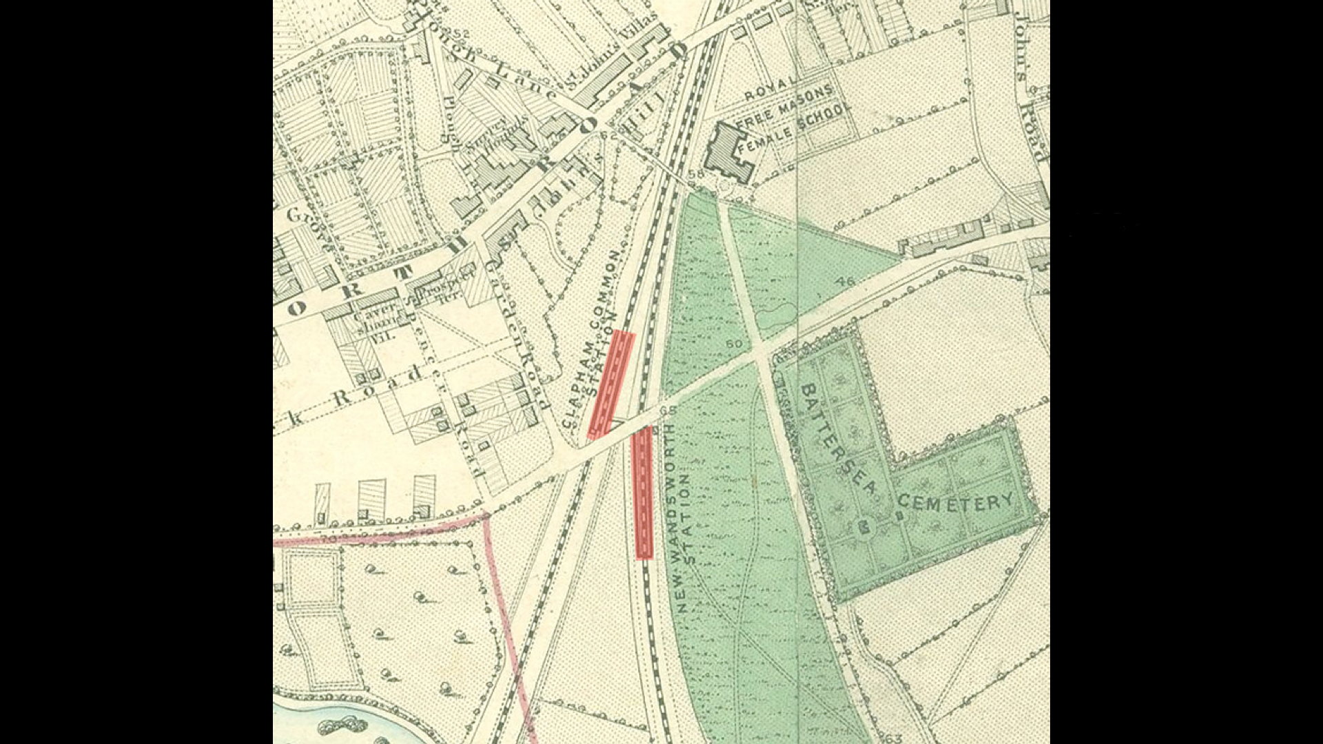
Earlsfield Road / Windmill Road / stops short at Battersea Rise railway bridge
Railways may solve many transport problems, but they create others - they cut through areas - interrupt roads - demand bridges and viaducts - many of which are very narrow - they create pinch points - up and make it harder for roads...
(Click on image to enlarge)
(Click on image to enlarge)
dates? / 3 maps by Cruchley
And the coming of the railway...
(Click on image to enlarge)
How many islands? 13? [or 7? or?] - one for every child? Did the railway cut through Black Sea? Stops water flowing naturally off the Common, hence a clay lining and a wind pump were necessary...
The Wilsons of Price's Candles / "Black Sea House"?
Earlsfield Road / Windmill Road / stops short at Battersea Rise railway bridge
Railways may solve many transport problems, but they create others - they cut through areas - interrupt roads - demand bridges and viaducts - many of which are very narrow - they create pinch points - up and make it harder for roads...
(Click on image to enlarge)
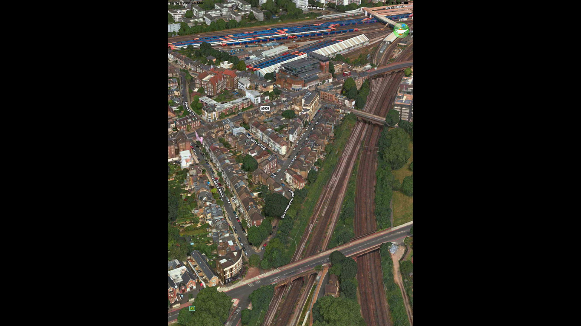
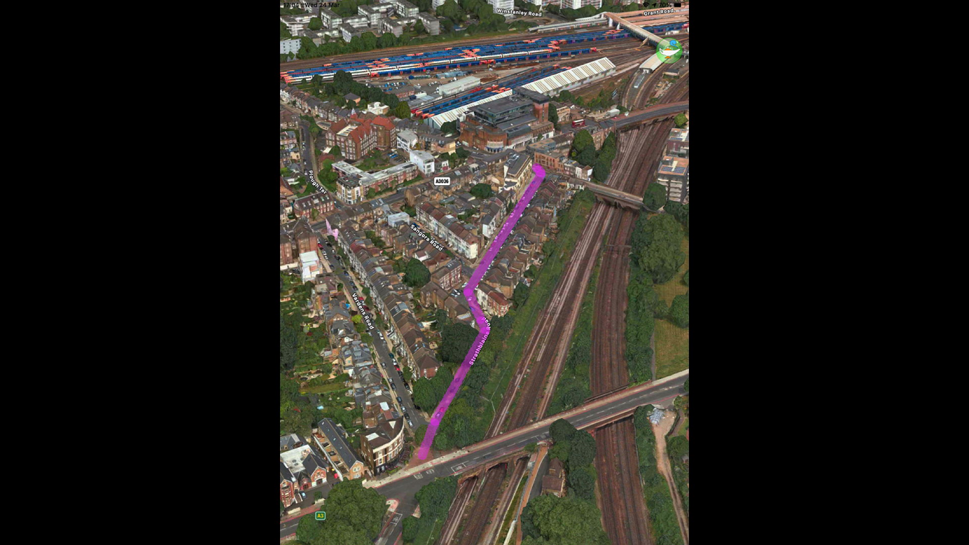
Incidentally, the original intention was to continue the road right through to St John's Hill, roughly along the line that Strath? now takes.
(Click on image to enlarge)
This is part of "Plough Green" - the site and cause of so much radical agitation in the 1860s.
Too much valuable building land was involved, and it never happened.
Which goes a long way towards explaining the awful muddle and congestion at the junction with the railway bridge.
This image is slightly earlier - date? - notice two stations - the absurdly named "Clapham Common" and "New Wandsworth"
(Click on image to enlarge)
(Click on image to enlarge)
(Click on image to enlarge)
Actually, this is not "incidental".One of the most loudly heard complaints during the Plough Green demonstrations was that the enclosures and barriers erected by [Forename?] Compton? Smith and [forename?] Costeker in this area impeded the access people had enjoyed "from time immemorial".
The railways lines- first the London Southampton, then the London-Crystal Palace / Brighton line had made access to this part of the Common for people of Battersea to cricket but also to the Black Sea was very difficult.
The agitation of the 1860s culminated in the 1871 Act, which saved the Common [for ever].
But at a price. A steep price. Negotiating with Earl Spencer [or rather, his lawyers and estate manager] was tough. He demanded £500 a year for the loss of his "rights". This was beyond the means of local people to raise in rates at this time [even if they were prepared to pay such an amount].
It was eventally agreed that local people would have to find be £250 a year in perpetuity.
I say in perpetuity - I still havent been able to find out whether the Earls Spencer continue to receive £250 a year or whether it was somehow paid off [which is what Wimbledon Common has done].
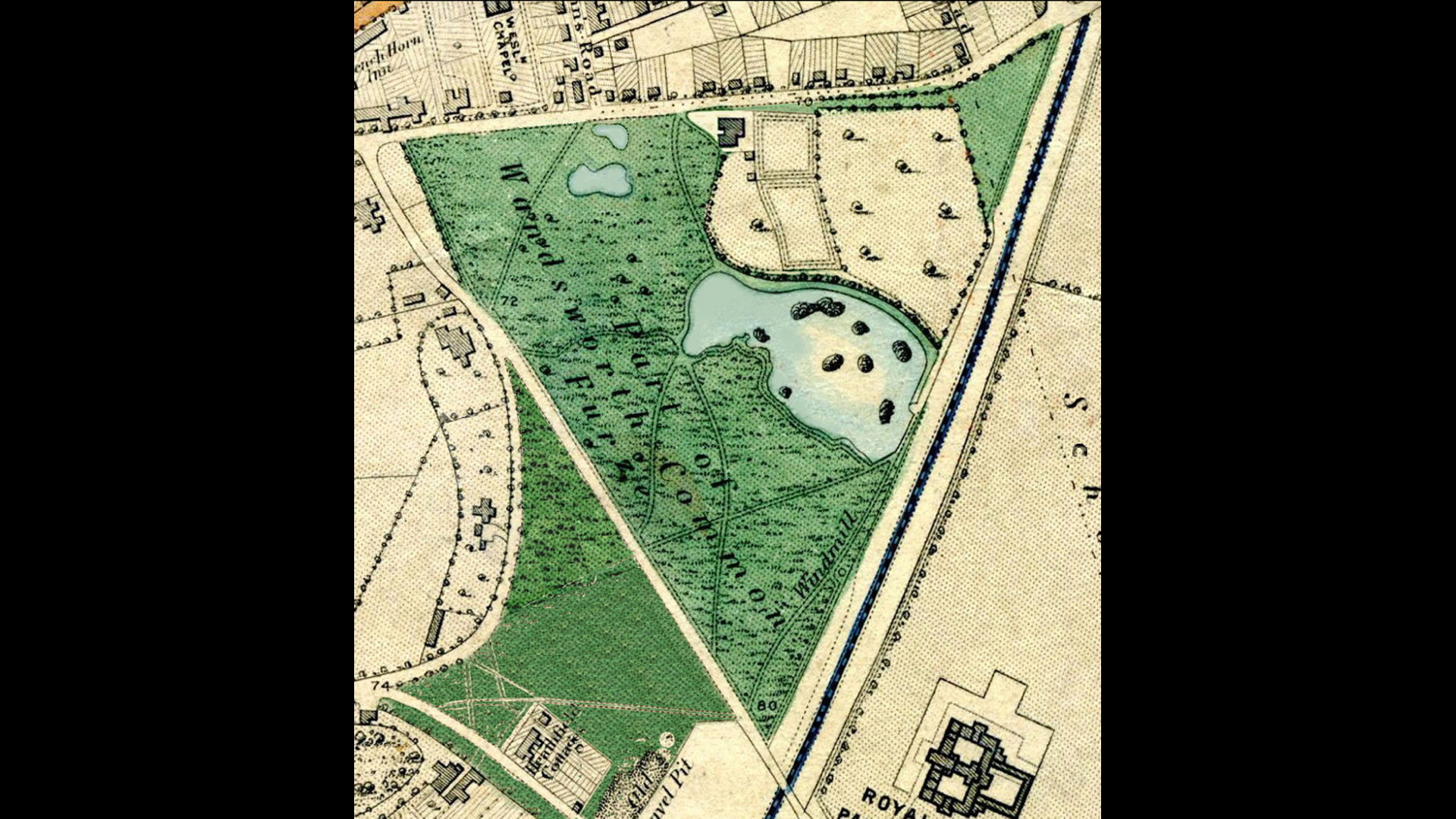
BUT the price was to return the Black Sea and nearby land one which Spencer could build a cherished project - "Spencer Park". [A vanity project?]
Here it is in the C19:
(Click on image to enlarge)
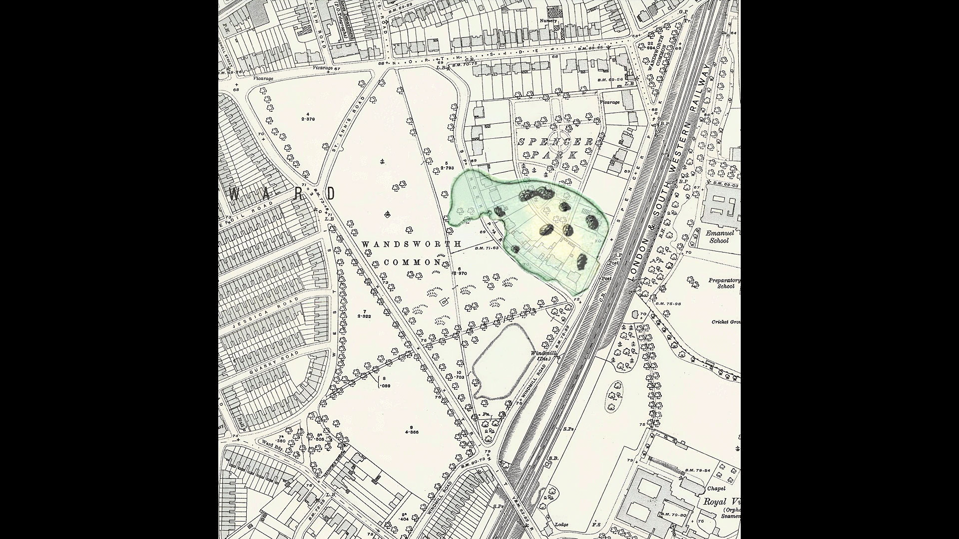
(Click on image to enlarge)
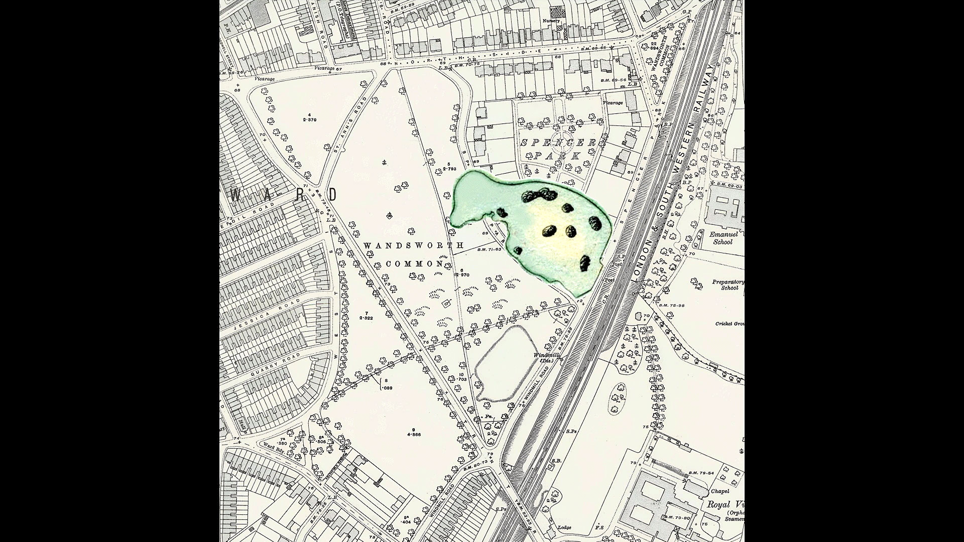
(Click on image to enlarge)
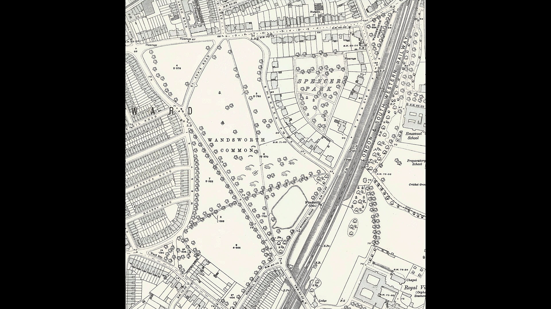
(Click on image to enlarge)
And here in an aerial photograph from the last couple of years:
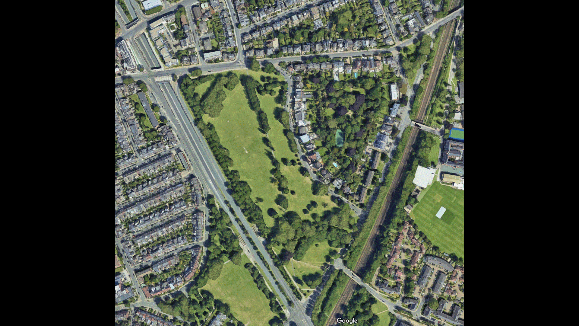
(Click on image to enlarge)
Within a few years, the lake was filled in.MOVE? DROP? The note on the back of the card says painted "around 1880"? Again, possibly. But if so, it was painted after the lake had been filled in - which (as we shall see) was some time between 1871, when the Wandsworth Common Act was passed, and the mid-1870s.
Let's go back to the map / look at a roughly contemporary map This is a hand-coloured Stanford map of 18?? There were numerous editions from ? to ? Given the sightlines, with a clear view of the RVPA, and with what is likely to be an small island on out ?, we must be somewhere here...or here Notice there is no evidence of a railway line in between "us" - the artists or viewer - and the enormous orphan asylum. Whenever this image was painted, it represents the last days of the lake. By 1880, it was gone, and Spencer Park built in its place. [Map from 1880s? Aerial pic?]
Now we have a problem. Did the railway line go through the Black Sea, or simply cut off its water supply? We know it did cut off the supply because.... hence court case? agreement for the railway company to provide a windpump and maintain the lake Are these maps accurate? Or at least accurate enough It certainly looks as though it went through...
Here are some images of this windpump - always called the Windmill, of course... Thanks to the efforts of the Wandsworth Society, a large part of it is still there today - though oddly camouflaged by trees as if it's lurking behind them
If so, the lake once spread into the grounds now occupied by Emanuel School. Now here's a little enigma. Until the 1930s [date?] there was strange wooded knoll "venerable elms" on what are now the school playing fields. Yes it got in the way, but it had its uses... ?picnics? ? military manoeuvres here are some photos from around But sport won , as it did more or less everywhere around. The knoll was removed etc Now what if this knoll was originally an island in the lake?
Ley's look at the islands in the lake. (And the family that lived newxt door.) Often stated there were 13 - one for each of William wilson's chilsdren Here's ?, the LCC ... Shirley Passmore, whose work on the history of Wandsworth Common continues to inspire and inform me, pooh poohs this. She points out the islands are already there in Cruchley's maps.
Collect and review all maps
yeah well yeah alright Willow I better run yes go down I just put the hot water on what no I've just put the hot water back on yeah you're all set up hello is it already fantastic very very good to me thank you thank you think my magic a cheers bye stop pause timer correct turn the living room lamp Time is it yeah no hello no turn off phone phone Midlane next track no what time is itShirley Passmore bits
Refs in newspapers etc
Photos e.g. by
Geoffrey Bevington - probably took several photos of the Black Sea and Black Sea House - get better versions?
Peter Le Neve Foster - I have a photo of the BS by him - but try to find the photo of his children boating there - said to be "his most charming photo"
There's a painting in the Wandsworth Heritage Centre/Borough Photos
Do I recall refs to watercolours e.g. possibly by ? Barchard?
Eels
Jack Black
Suicides e.g. the two Amelias
Infanticide
Deaths on the ice
"Botany Bay"?
The trap laid for the foreign seducer
Other plants, insects etc in the lake
The Elodea canadensis invasion
George Fergusson Wilson models Wisley/future RHS on Wandsworth Common
The Windmill
Stories about the Frying Pan
Collect every photo and reference
Buckmaster et al's complaints about how they used to be able to walk all round.
Afterwards, how the rest of the ponds were filled in. How the lake was created and enlarged.
Collect info about how polluted, evil-smelling it had become
Find story about how it was blamed for deaths in the RVPA for Girls - then detail how the sewers worked, with human excrement spread on the groiunds (and on Neal's bit of the Comon? - the death of Dr Anstie blamed on the sewer gases (but was actually septicaeia briught in by a prick during dissection)
How the lake was filled in. And Spencer Park was built on the site. Whobuilt the houses? Who lived there?

(Click on image to enlarge)

View from Black Sea towards the RVPA, c. 1880
[PB: This may (or may not) be the date of the painting - but the Black Sea had been filled in some years earlier - 1871-ish?]
'"The Royal Victoria Patriotic Asylum, Wandsworth Common" (c.1880). Watercolour, artist unknown. I scanned this from a Wandsworth Museum greetings card. I was unable to find it online in July 2019, but I assume it is in storage somewhere. Is it listed in ArtUK? No. [It might be now - check].
(Click on image to enlarge)
Why is it called "The Black Sea"? Is it Crimean-war connected? There is a painting dated 1858, so it could be. Or are there references prior to 1853/4? Was the house also called Black Sea House, as I recall one source saying?
[No, there are references to the Black Sea from well before the Crimean war [i.e. pre-mid-1850s] - find.]
Price's Candles certainly used an image of Cardigan and the Charge (and other battles) in their publicity [date?].
The Black Sea (Spencer Park)
Built by ? Wilson, owner of Price's Candles. According to Sexby Municipal Parks... [1905], an extra island was created for every new child. (Shirley Passmore pooh-poohs this on the grounds that the many islands can be seen on maps made before the children were born. Check.)
When the control of the common was transferred to the conservators, Lord Spencer reserved to himself a portion at the north adjoining the London and South-Western Railway main line on which was a sheet of ornamental water called the Black Sea, which was studded with thirteen small islands, and beautified with shrubs and flowers. This lake was formed by a Mr. Wilson, the founder of Price's Candle Works, who lived at Black Sea House. For every child added to his family, he constructed a little island in the lake, fringing each with yellow iris.
In the Act for the construction of the railway, the Black Sea was called Pond No. 3, and was said to be the property of Battersea and Wandsworth, [p.246] and by this Act the Company were compelled to place apart the sum of 8,000 for the purpose of covering the bed of the pond with clay, and making a drain into it from the cutting, and keeping it in good condition. Shortly afterwards in another Act certain sections enabled the Company to withdraw this sum, but still they were bound to repair and keep intact the pond and drain on both sides of the railway.
The Black Sea has now been filled up, and Spencer Park has been built upon its site so that one of the most picturesque and ornamental waters near London has disappeared. The old windmill, of which the stump remains (which is utilized as a tool-shed by the labourers on the common), was used for the purpose of pumping water into the Black Sea.
* "Old and New London", vol. vi., p. 482.
Shirley Passmore, The Black Sea
The Wilson Estate and the Black Sea
An early enclosure (date not known) on the north-west comer of the common was a house surrounded by a large garden that later expanded to about 8 acres of parkland. It is shown on the Rocque map of 1741.
The estate was leased in 1829 from Earl Spencer by William Wilson the founder of Price's Candle Factory. On later maps a 5-acre lake known as The Black Sea adjoins the park. This was most probably a disused gravel pit and later was utilised as a reservoir. It supplied 12,000 gallons of water a day to properties around.
[PB: her sources?
When the cutting for the London Southampton Railway was made it cut off the end of the lake and its feeder spring. The LSR Company was obliged under the 1834 Act to take various steps to "for ever thereafter keep up and maintain a supply of water in the said pond No 3 and two other ponds contiguous thereto" (or until the Lambeth Water Company would take over the supply). A pumping mill was installed on the railway embankment to pump back water from the cutting into the lake.
[The Black Sea, Stanford 1864. Source and further information: Link.]
At some stage, perhaps 1846 when a new lease is recorded between Anne Wilson and Earl Spencer, the estate was expanded right up to the edge of the lake taking in one and a half acres of common. The lake ceased to be a reservoir at about this time and it is suggested that the 1846 Lease also included the lake. However, the Battersea and Wandsworth parishes were stated to own the lake when used as a reservoir so the situation is unclear.
What is clear is that at least from this time, perhaps earlier, Wilson looked after the lake and was responsible to a large extent for turning it into "One of the most picturesque and ornamental waters near London". It has to be a myth that he put in an island to commemorate the birth of each of his 13 children because the islands are already there on the Cruchley map of 1829.
In November 1866 the fifth Earl Spencer bought back the lease of this estate from the widow of William Wilson and "the gravest apprehensions were entertained that the 13 acres would be turned into building sites". (It was to become Spencer Park).
[Shirley Passmore, 2010]
(Click on image to enlarge)
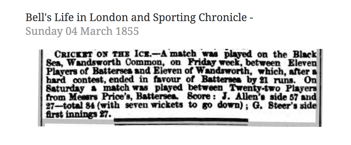
Bell's Life in London - 4 March 1855
Cricket on the ice
(Click on image to enlarge)
Cricket on the ice
The match was played on the Black Sea, Wandsworth Common, on Friday week, between 11 players of Battersea and 11 of Wandsworth, which, after a hard contest, ended in favour of Battersea by 21 runs.
On Saturday a match was played between 22 players from Messrs Price's Battersea. Score; J Allen's side 57 and 27 total 84 with seven wickets to go down; G Steer's side first innings 27.
[Source: Link.]
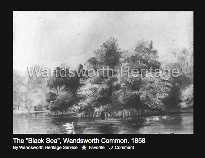
Black Sea, 1858, watercolour?
From Wandsworth Heritage Service. Link? Do they have a better copy? the original watercolour?
(Click on image to enlarge)
Jon Newman, Battersea's Global Reach: The Story of Price's Candles
Battersea's Global Reach tells the story of Price's Candles at Vauxhall and Battersea and how it helped to light the world. Price's Candles of Battersea was and still is a household name. Yet the company's history is so much more than the making of candles. From its inception in the 1830s it re-invigorated a sleepy and unchanged industry by the application of scientific research. Industrial chemistry allowed it to develop the first stearine candles and provide inexpensive good quality lighting.
Forty years later the discovery of oil and the use of paraffin wax for candle manufacture additionally turned it into an position oil company. As well as commercial success the company was noted for its ethical on products - particularly the use of Palm Oil for manufacture and the strong anti-slavery message that this sent out in the 1850s - and for its radical approach to employee relations, providing schools, housing and pensions for its workers. The story of the 20th century is a familiar one of decline and reinvention - from manufacturing industry to retailer to heritage brand.
Jon Newman, the author, is an archivist working freelance and for Lambeth Archives.
Published by History & Social Action Publications, 6 Oakhill Rd, London, SW16 5RG.
Launched at a talk by the author during the Wandsworth Heritage Festival (June 2009).
Price: £5 & £1 p&p.
To order:
Click Add Cart button below or send order with cheque payable to 'Sean Creighton' to the address above.
Or order via email: sean.creighton1947@btinternet.com.
https://sites.google.com/site/historysocialaction/battersea-s-global-reach
"WANDSWORTH COMMON BLACK SEA" SEARCH IN GOOGLE BOOKS
http://books.google.co.uk/books?id=gdlCAAAAIAAJ&q=black+sea+wandsworth+common&dq=black+sea+wandsworth+common&pgis=1
WC in he Municipal Parks, Gardens, and Open Spaces of London
By John James Sexby
[Source: Link.]
More details
The Municipal Parks, Gardens, and Open Spaces of London: Their History and Associations
By John James Sexby
Published by E. Stock, 1905
646 pages
Autobiography of Sir Walter Besant (1836-1901).
Besant moved from Portsmouth? to London (at age ?) to study at Stockwell Grammar School.
[p.61]
There were many curious and pleasant places within reach of Stockwell. Clapham Common, on the south, the first of the Surrey heaths. It was surrounded by stately mansions, sacred to the memory of Wilberforce, Thornton, and Macaulay, standing amidst broad lawns with splendid cedars. The common itself was left absolutely untouched; winter water-ways made little ravines; there were ponds, there were no roads, there was gorse and fern. It was our playground.
Beyond lay [p.62] Wandsworth Common, another wild heath with a lake called the Black Sea, wherein, it was rumoured, gigantic pike attacked and bit great holes in the boy who ventured to swim across.
On the west one could easily reach the Battersea Fields. As I recollect this place, it was most dreary and miserable; a broad flat, lower than the river, and protected by an embankment. On the bank stood the once famous Red House tavern, now long forgotten, and beside it the pigeon-shooting ground. This sport went on continually. If a pigeon escaped he was potted by men who carried guns and lay waiting for him outside the grounds. Battersea Church was on the wall of the Fields, the transformation of a great part of which into Battersea Park took place between 1851 and 1858.
In summer our favourite rambles were farther afield, in the direction of Champion Hill, Herne Hill, Dulwich, and even Penge. No one visiting these places at the present day can understand their loveliness before they were built over. Dulwich, with its ancient college and its inn, its greenery and its orchards, was surely the sweetest village in the world. I always looked about in case I might come upon Mr. Pickwick, who was then a resident, but I was never privileged to see him. The hanging woods of Penge in autumn were lovely beyond the power of words. Its Common on the Hill had been enclosed long before in 1824. Howe laments the fact in that year; but in the fifties Penge, Norwood and Sydenham formed a group of suburbs still rural, [p.63] still covered with woods and gardens, and as beautiful as any country village.
As yet there were neither omnibuses nor railway. The people who went into the City drove in their own carriages or rode their own horses. Any morning along the Clapham Road there were still many who rode into town.
We were not great at games at the school. There was a cricket club, but my short sight disqualified me from any game of ball; in the winter there was hockey on Clapham Common. I think that football had not yet come in; in fact athletics, in such schools as this was, hardly existed. On the other hand we took long walks; we walked to Richmond, and rode ponies in the Park; we walked to Putney, and took boats on the River; we jumped the Effra, in the Dulwich Fields; we had a gymnastic bar and did things of strength; sometimes we wrestled; sometimes we fought. On the whole it was a healthy kind of life, with plenty of outdoor exercise.
For my own part, I had a form of recreation all my own, of which I said nothing, because the other boys would not understand it. I had friends at Camberwell and Brixton, who asked me two or three times a term to dinner on a half-holiday. On such occasions I used to get away at two and walk all the way into the City of London, which was to me then, as it has been ever since, a place of mystery, full of things to be discovered. Nothing could be more delightful than to wander about, not knowing where, so long as one was in the City.
[Source: Autobiography of Sir Walter Besant, Hutchinson & co., 1902.
Various formats available at here. Downloaded and saved as e.g. "BESANT_AUTOBIOGRAPHY_OF_SIR_WALTER_BESANT_autobiographysi01besagoog.pdf". Also a text version (partly edited).]
- Wikipedia: Walter Besant
Times, 6 March 1868
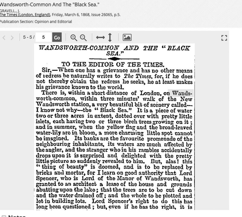
"But, alas! this thing of beauty is doomed", The Times, 6 March 1868
[to be completed]
(Click on image to enlarge)
The Popular Science Review: Animalcules, Wandsworth Common
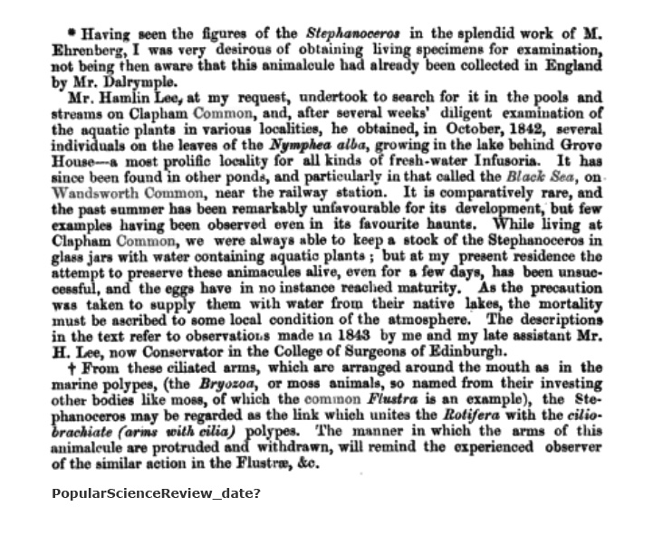
Popular Science Review, date?
(Click on image to enlarge)
Nymphaea alba - Wikipedia: https://en.wikipedia.org/wiki/Nymphaea_alba
Beautiful short film of the rotifer Stephanoceros fimbriatus
Published Jun 29, 2017. The rotifer Stephanoceros fimbriatus. Collected from a Southern California mountain lake, this was filmed in full 4K using a Panasonic GH4 camera, an Olympus BHS microscope, SPlan objectives, and Olympus DIC.
Also Link.
NB Philip Gosse, 'On Stephanoceros,' 1862.
On distribution of Rotifera, including Stephanoceros: Link (fabulous last para!)
Windmill
- See The Windmill
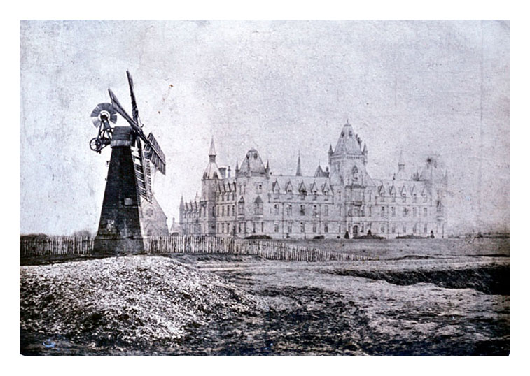
Windmill supplying water to Black Sea after railway cutting interrupted natural supply, date? Royal Victoria Patriotic Asylum for Girls in the background.
Notice how bleak and treeless the area is at this time.
windmill_in_front_of_rvpa.jpg
(Click on image to enlarge)
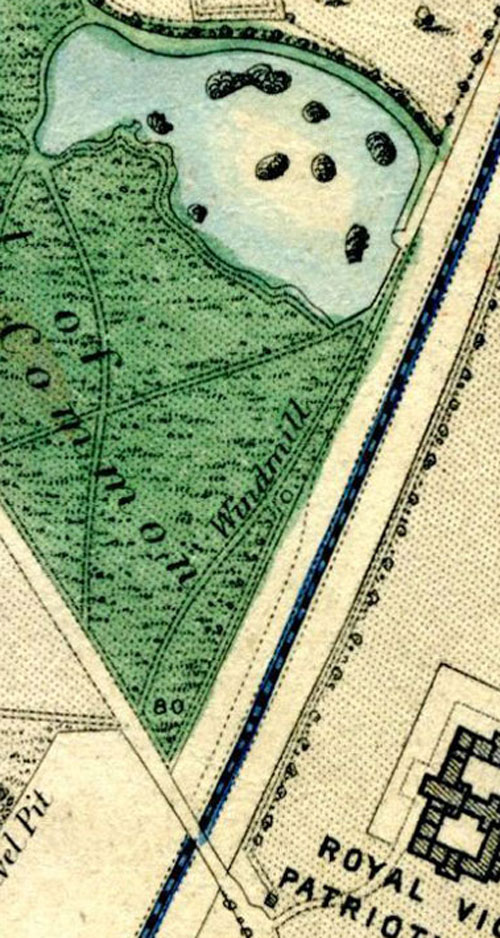
Map: Black Sea, Windmill, RVPA, railway line.
map_black_sea_windmill_rvpa.jpg
(Click on image to enlarge)
The Frying Pan
[PB: Notice there is no "Frying Pan" - the dead-flat depression on the other side of Windmill Drive opposite the RVPA. When did it appear? Find on maps. What was extracted and why? Was it to fill the Black Sea? This seems reasonable. I have seen a reference once [Greg Smye-Rumsby in his Scope website] that it was dug to make bricks for the Prison - but this seems unlikely. Was there much/any clay suitable for brickmaking on WC? Probably not. To build what? - the main part of the prison having already been built by the time of this image. No, it was a later sand pit. The "handle" is the approach path on the western side.]
Shirley Passmore: The Wilson Estate and the Black Sea
The Wilson Estate and the Black Sea
An early enclosure (date not known) on the north-west comer of the common was a house surrounded by a large garden that later expanded to about 8 acres of parkland. It is shown on the Rocque map of 1741.
The estate was leased in 1829 from Earl Spencer by William Wilson the founder of Price's Candle Factory. On later maps a 5-acre lake known as The Black Sea adjoins the park. This was most probably a disused gravel pit and later was utilised as a reservoir. It supplied 12,000 gallons of water a day to properties around.
When the cutting for the London Southampton Railway was made it cut off the end of the lake and its feeder spring. The LSR Company was obliged under the 1834 Act to take various steps to "for ever thereafter keep up and maintain a supply of water in the said pond No 3 and two other ponds contiguous thereto" (or until the Lambeth Water Company would take over the supply). A pumping mill was installed on the railway embankment to pump back water from the cutting into the lake.
At some stage, perhaps 1846 when a new lease is recorded between Anne Wilson and Earl Spencer, the estate was expanded right up to the edge of the lake taking in one and a half acres of common. The lake ceased to be a reservoir at about this time and it is suggested that the 1846 Lease also included the lake. However, the Battersea and Wandsworth parishes were stated to own the lake when used as a reservoir so the situation is unclear.
What is clear is that at least from this time, perhaps earlier, Wilson looked after the lake and was responsible to a large extent for turning it into "One of the most picturesque and ornamental waters near London". It has to be a myth that he put in an island to commemorate the birth of each of his 13 children because the islands are already there on the Cruchley map of 1829.
In November 1866 the fifth Earl Spencer bought back the lease of this estate from the widow of William Wilson and "the gravest apprehensions were entertained that the 13 acres would be turned into building sites". (It was to become Spencer Park).
[Shirley Passmore, 2010]
Follow up
- Jack Black
- Ornamental lake or reservoir (or both?)
- Refs to its decline in later years
- Info about filling in and our other lake created
NB Locate and add info about Peter Le Neve Foster's photograph of his children boating on the Black Sea c. 1850s.
Also his photo of a lake, whic may be the Black Sea.