
Notes put together for the 5 May 2024 perambulation. The walkers met at the Boundary Oak.
With additions April 2025 for Stephen Midlane:
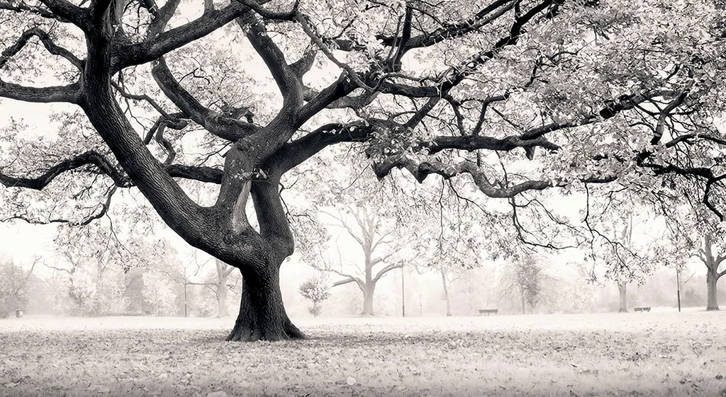
We're gathering together today by what we call the Boundary Oak.
It was Stephen Midlane who first pointed this out to me — well spotted, Stephen!
Once seen (and touched), boundary markers such as this tree are never forgotten — which was what perambulations are all about.
Impress a memory of this tree on your grandchildren and in 70 or 80 years time, at the end of this century (all being well) they will be pointing it out to their grandchildren.
Originally no boundary posts or stones — or very few.
Often natural features, such as trees — like this one.
School boys — esp. pauper schools Why? Because they needed to be "educated" in these matters . . . and because you could more easily get them to scramble through hedges, climb over fences and walls . . .
And so on . . .
Pedagogical techniques:
Willow wands — hitting boundary markers
Bumping
Pushing men and boys into streams and ponds
Singing hymns esp. verses of Psalm 104 — in sequence at different points
The time line stretches back to "time immemorial" [and forward to "time inconceivable"?]
In truth, we're not absolutely certain that it was planted for that purpose, or exactly when, but it certainly seems likely. It's certainly on the line, and that's what counts.
[We know from an C18 will that a man left money for an oak to be planted on the Streatham/Battersea border — just over there, on the other side of Wandsworth Common Station — this was in the mid-1700s. [Add details]]
Why an oak? Well they're good old English trees, easily identified, and they last a very long time.
[Gospel Oak in North London refers to one. Angus Winchester, Discovering Parish Boundaries, p.41, refers to the importance of The Vicar's Oak in settling a dispute between Croydon and Penge (then an exclave of Battersea).]
So how old is this tree?
[A tree expert estimates it was planted about ? years ago, around ?]
There isn't much time, and there are a lot of things to say. So let's focus on the boundary around the edge of the Common east of here, and up through the middle.
From Battersea's point of view, this boundary stakes a claim that you are now in Battersea's Common land — this was Battersea West Common.
(The other side of the line, which is shared with Wandsworth, is Wandsworth's East Common.)
Let's follow the line down Nightingale Lane from Clapham Common . . .
You crossed the Falcon Brook (now in a pipe underground)
Until c.1890 you would then have gone up Nightingale Lane until you reached Nightingale Lodge, once on the edge of the Common.
The Lodge stood just below the plot of land, filched from the Common, on which today's Mormon church, now stands .(The Mormons are a US-multinational religious corporation that arrived in the 1930s.)
At Nightingale Lodge you would have turned left along "The Drive" that curved past a number of large houses, including Fernside.
Before the 1850s, when the railway cut the Drive short, you would have perambulated along the Drive
In the 1860s, you could still walk across the track. (Wandsworth Common statio opened in 1869.)
Today you have to cross the track at the Station, then walk alongside the railway line, when you pick up all that remains of the Drive — that little alley to/from the Common leading into Balham Park Road..
The Drive ran behind/around the St James's Industrial School (1840s) — an early loss to the Common engineered by the then Lord of the Manor Earl Spencer. [Spencer III? IV? V?)
Then things get very curious indeed . . . .
The boundary goes down to the farthest point south, then turns up and proceeds in a straight line more or less northward (north-westward) across the Common until it reaches what we now call Battersea Rise . . . .
I often think of this call this Battersea's sting in the tail
Why this shape?
An interesting question.
Lots of theories, but the one I like is that it encloses a row of prehistoric burial mounds. (Neolithic, Bronze Age or Iron Age )
There is no record of this, and so far as I know nobody has ever done any archaeological investigations here.
But there was a possible example not too far away, on Bedford Hill. This was 100 feet long and ?? feet high. It was flattened just before WWI to make way for housing.
[QUOTE — I have a reference. See Taylor, Our Ladye]
[Much more on this below]
It isn't a straight line any longer, because it has to take into account all the roads that have been built, and new buildings . . . .
Things became very complicated when a house and garden were built on the boundary . . . for example, did you have to pay rates to both vestries (Battersea and Wandsworth)?
But when it was an uninterrupted (and relatively featureless) Common . . .
Perhaps that's why this Boundary Oak was important?
And of course the many later boundary markers/posts
As you can see from here — the B-W boundary is NOT the railway line, as many people assume. The railway came a lot later.
Many parish boundaries are rivers and streams — so obviously not that either.
It's not the top of a ridge (which would be more or less Beechcroft Road-Lyford Road- Heathfield Road)
It is not equidistant between the two rivers that in effect created the Common (by cutting like a cheese wire through the massive gravel terraces of SW London down to clay beneath) the Wandle and The Falcon Brook
[Hence Wimbledon Common/Wandsworth Common/Clapham Common]
[BTEW the rain that falls on the Common is not shared — ALL the water that falls on Watdsworth Common flows towards Battersea — it flows across the tilted WC plateau down to the Falcon Brook, and thence to the Thames.]
In short, the line is drawn more or less to divide the Common in half so that the people of Wandsworth AND Battersea, although in different manors/parishes, could SHARE the resources it provides:
They practised "inter-commoning".
The traditional Wandsworth— Battersea boundary is crossed in a number of places behind today's "Toast Rack" — there are probably more boundary markers in this area than anywhere else around the parish. This reflects a complex history in which, many centuries ago, Allfarthing Manor was given a small foothold on the Common — the "Allfarthing Piece" (on which more another time).

[From then until] early in the nineteenth century the larger manor itself was subdivided (for example, "Allfarthing", "Doune", and other small manors were carved out too) but there were still only two parishes: St Mary's in Battersea and All Saints in Wandsworth.

[The mostly straight boundary across Wandsworth Common down to the Thames is intriguing. I'll have more to say about this later.]
Simplifying a bit, our story starts in Anglo-Saxon times, from about AD650 [?] when there was just one big manor here — let's call it "Wandsworth-cum-Battersea".
It was divided into two parishes, and later into two manors:
This boundary across the Common separated Wandsworth Manor from Battersea Manor, All Saints Wandsworth parish from St Mary's Battersea.
[There were other, smaller manors, such as Allfarthing, and Dunshill.]
Today's Wandswworth Common was long stretch of high infertile land between Battersea and Wandsworth. There were probably never any field boundaries or fences. The Common was attached to the manor, and available for use by all commoners in the manor.
Clapham Common is a misnomer — it's two commons so should be called "Battersea & Clapham Common" — part Clapham Manor, part Battersea Manor.
Similarly, Wandsworth Common — again, two commons — should be called "Battersea & Wandsworth Common" — part Battersea Manor, part Wandsworth Manor.
In fact there's a third common, attached to Allfarthing Manor — this is seen on old maps of the Common [c.1640] as "Allfarthing Piece", a projection into the Common three or four hundred years wide, from c. Lyford Road & Heathfield Road across to the W-B boundary.
This "Piece" was enclosed shortly after 1800, leased out as market gardens/ nurseries (to e.g. the Neal family). Then built over as the Toast Rack.
[You can see the result of this barbarism over there . . . ]
This was a major loss to the Common, courtesy Magdalen College Oxford, who (from the 1840s) were gifted much of Allfarthing Manor by Sophia Sheppard (the land — she (and Magdalen after her) were never Lords of the Manor.)
By the 1860s Earl Spencer controlled them all
He started with Wimbledon in [1760s?]
[because . . . ]Earls Spencer then tried to collect the set.
(or most of them, though not Clapham or Tooting and Tootig Graveney or Streatham):
Battersea in [1780s?]
Wandsworth in [??]
Allfarthing in [1820s??]
(and other manors, such as Putney? and Barnes?)
The Spencers often sold manorial land (they needed the money), but took care to retain manorial rights.
Simplifying things a little, the Battersea-Wandsworth boundary over Wandsworth Common is more or less a straight north-south line down the middle of a long hill — a spur thrusting out towards the Thames.
[Well, not quite north-south — it's tipped a little to the north-west/south-east.]
What are Commons used for? Why were they so valuable to local people?
Grazing for animals (e.g. cows, horses, donkeys, pigs, geese)
Birding, rabbiting, fishing.
Firewood
Turf (for heating)
Topsoil
Gravel
Sand
This list emphasises economic extraction. But Commons were also valued for their beauty, their air, their views, and openness. People could walk and play freely on the Common. Sporting events (cricket, quoits, pugilism, pedestrianism, terrier-hunting) typically took place here. Gambling was common.
The whole of Allfarthing-Battersea-Wandsworth Common coud be used and enjoyed by commoners from all three manors. (In practice, commoners from other manors also, and itinerants, such as "Gypsies".)
Inter-commoning was usually conflict-free.
I know of no conflicts between the people of Wandsworth and the people of Battersea or Allfarthing. (NB population numbers were very small.)
BUT very different between Battersea and Clapham!
In the early 1700s, Battersea complained that Clapham was taking all the good things from the Battersea side of Clapham Common — turf, soil, gravel, sand — which left big water- and refuse-filled holes in the Battersea side but left their own side intact.
Battersea-ites dug a big ditch (and probably a palisade fence to keep the Claphamites out.
The case went to court (at Kingston) but was ended without a clear resolution. The exact curse of the Battersea-Clapham bounary crossing Clapham Common was still being disputed in the middle of C19.
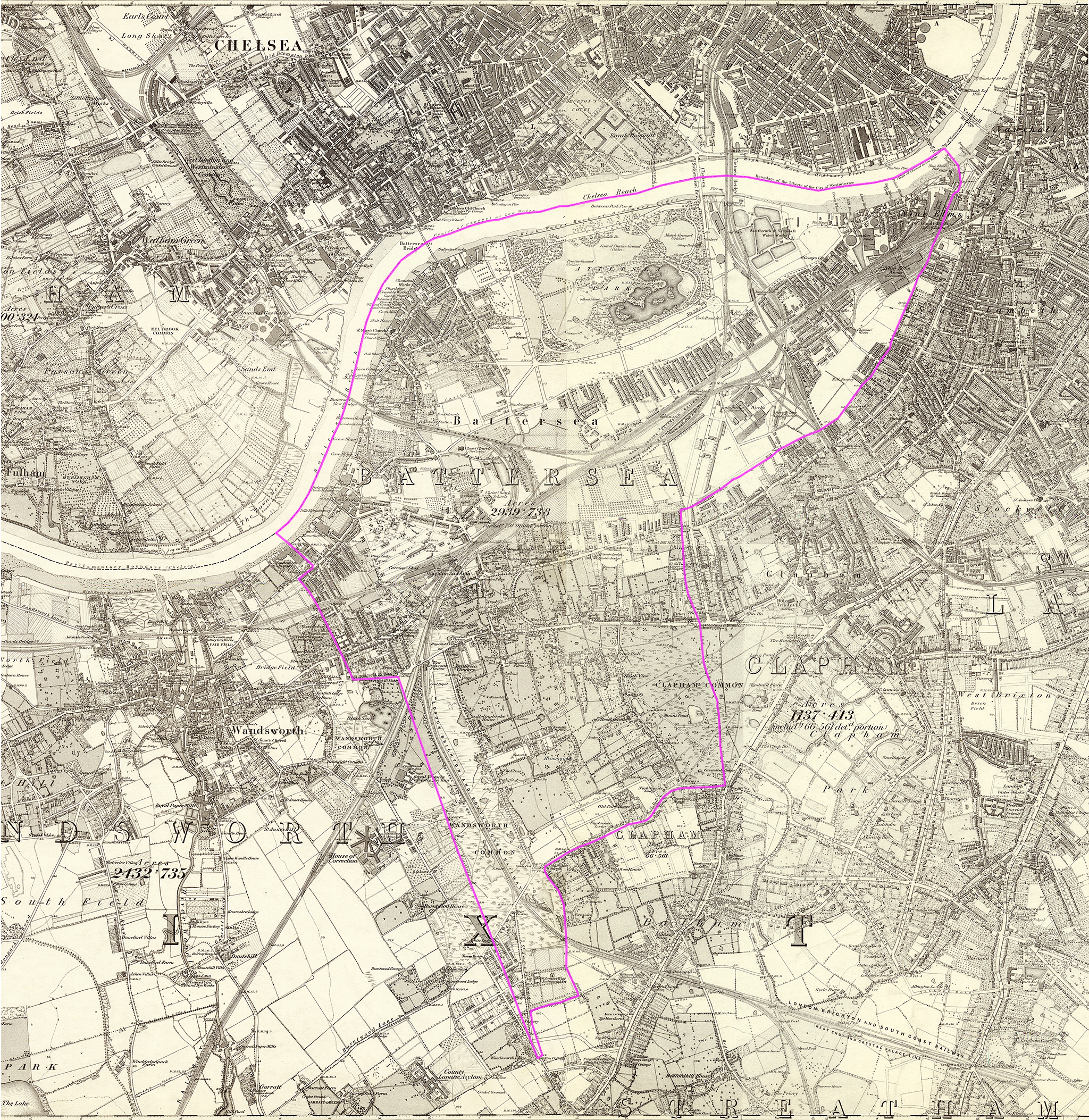
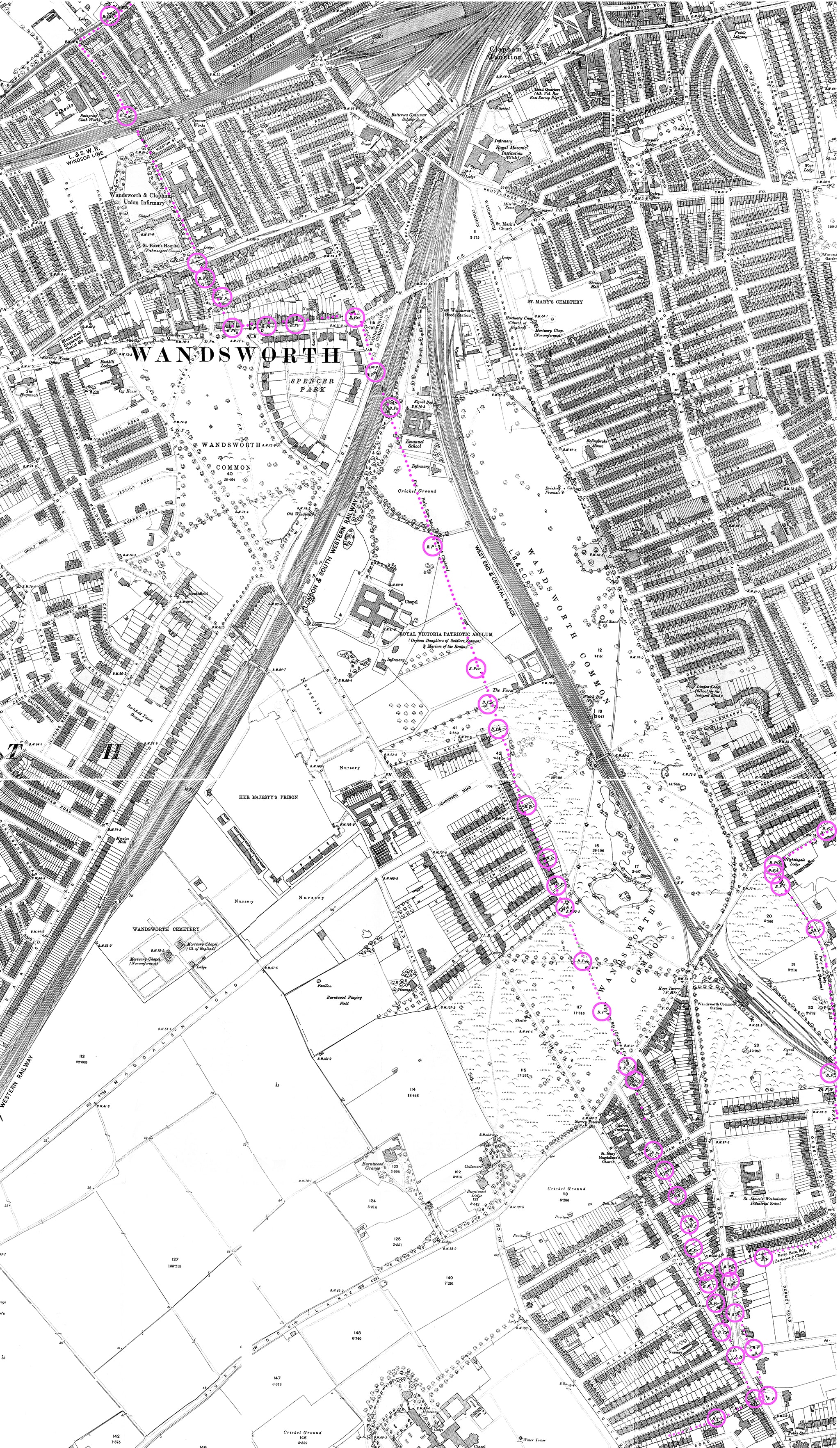
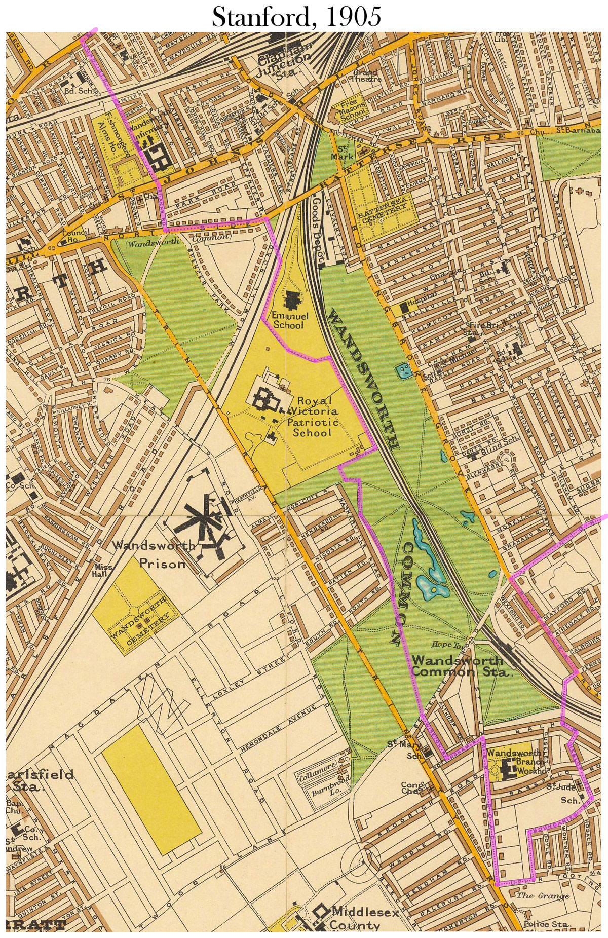
I've highlighted the perambulation on Stanford's 6-inch Library Map of London 1862. The walk proceeds clockwise, in customary fashion, beginning and ending near the parish church of St Mary's.

A more detailed view than Stanford's, containing very precise information about the boundary's position with respect to landmarks. [To follow up . . . ]
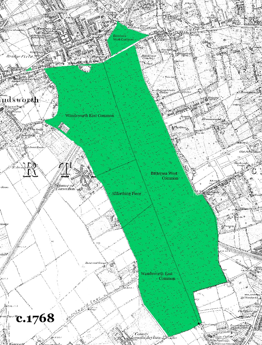
Here's a simplified image of Rocque's Wandsworth Common imposed on an Ordnance Survey map from 1868. I have also added the bounds of the three manors that inter-commoned here.
["Inter-commoning" allowed the sharing of the resources of the entire area of Common (for pasturing of animals, digging of gravel, cutting of turf, collection of firewood etc), even though the contiguous parts were legally attached to separate manors.]
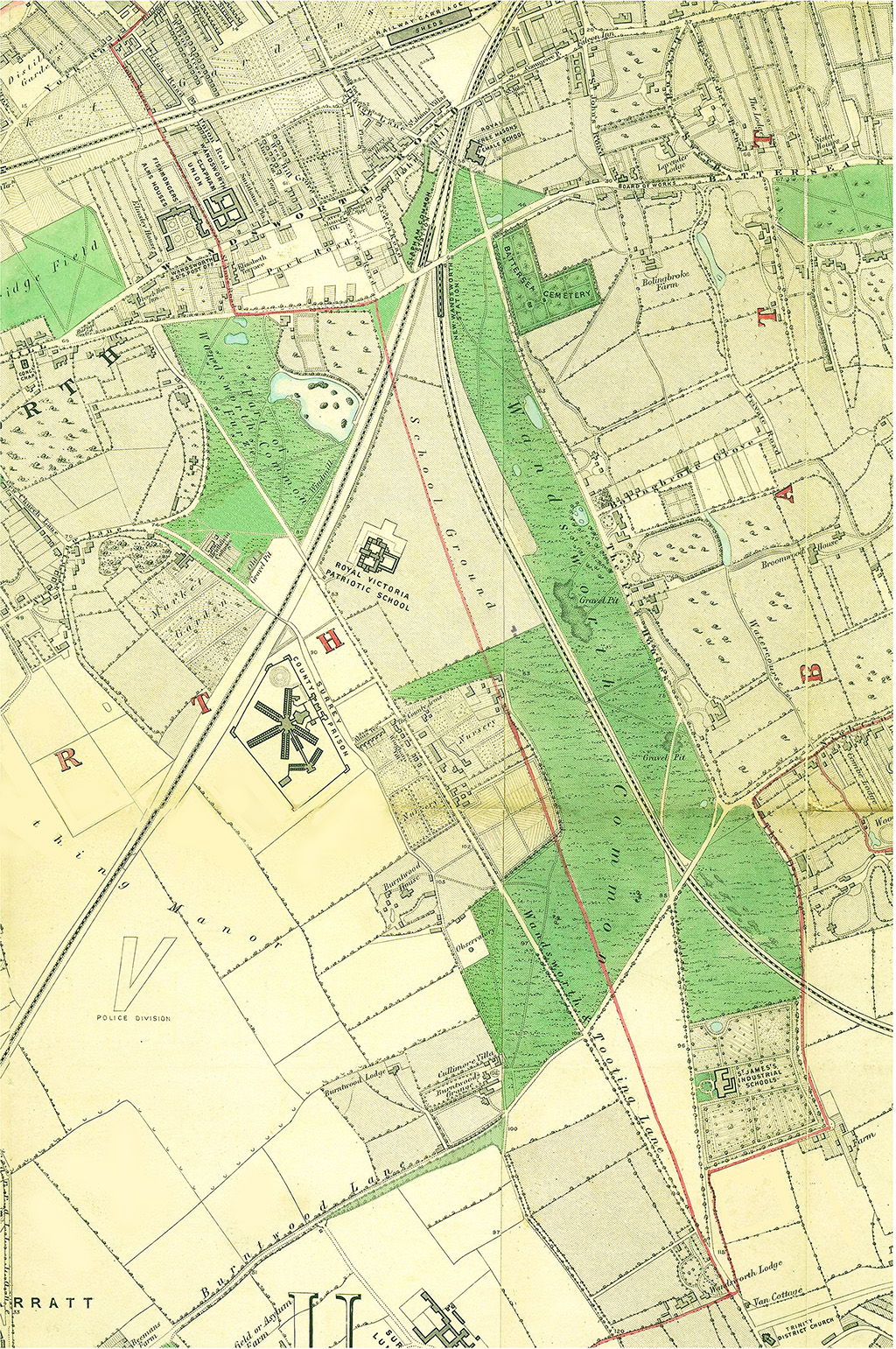
By the late 1860s, a century or so after Rocque's map was published, the Common was much smaller, it was criss-crossed with roads and railways, and ringed around with large houses and state and charitable institutions (schools and a prison). In the late 1850s the Patriotic Asylum ate the heart out of the Common — more than 50 acres.
MUCH MORE on view-source:https://www.historyofwandsworthcommon.org/boundaries/beating-the-bounds-1862/beating-the-bounds-1862.html
"The journey across Clapham Common was rather difficult . . . "
The journey across Clapham Common was rather difficult; the old boundary posts have either been removed or perished, but some knowing fellows who accompanied the expedition enabled the parochial officers to decide on those points, where good and substantial marks should be placed. This went down in the book, with the footpath.
[Perhaps significantly, the north-south boundary across Clapham Common is not dead straight, between two or more fixed points at either end, which would have put an end to any confusion. It veers slightly eastward and westward. Why?
[Notice the line more or less divides the Common between Battersea and Clapham. (Just as Wandsworth Common is more or less divided by a south-north-line between Battersea and Wandsworth further round the perambulation. ) Sharing was . . . ]

"The south side of Nightingale Lane . . . "
From this point you pass along the front gardens of all the houses on the south side of Nightingale-lane [9]. A row of old pollard oaks forms, in fact, the boundary lines at the road and about half of all the front gardens are in Battersea parish, and the houses in Streatham.
[Actually, not (mainly) in Streatham but a "detached" part of Clapham. Notice how much of this section of the Clapham/Streatham border is defined by the "York Sewer" — the Falcon Brook.]

Some Boundary Posts along Nightingale Lane . . .
Today (12 May 2023) I took some quick snaps of boundary posts on Nightingale Lane. I probably didn't find all, but there were quite a few. It would be wonderful to locate and photograph all of the boundary markers around Battersea parish.
Here is a selection:


[10]
"A respectable white-looking house . . . "
At the Wandsworth Common end of Nightingale-lane you see a respectable white-looking house, just painted inside and out [10]. Part of this house is in Battersea parish, and when the army collected in a confused heap before the front door, the servant, in her own expressive language, "wondered what was up."
This must be "Nightingale Cottage", seen here on an Ordnance Survey map of 1868:


The Churchwarden and Vestry Clerk were admitted, and the boys, who like seeing the inside of strange houses, were rather disappointed.
"Twenty-five years ago the present Bishop of Bath and Wells cheerfully underwent the proper bumping at this spot . . . "
The conspicuous white post at the corner was impressed on the memory by the usual bumping, which, at various points, had distinguished the day's proceedings; and it is worthy of remark that twenty-five years ago the present Bishop of Bath and Wells cheerfully underwent the proper bumping at this spot.
This must be a mistake, although a strange one. The Bishop of Bath and Wells at this time was Robert Eden, 3rd Baron Auckland, who has no (known) connection with Battersea. So who was it?
The reference seems more likely to be to local-boy Samuel Wilberforce (1805-1873), son of the famous William (the MP who led the anti-slave trade movement).

Widely known as "Soapy Sam" (thanks to what Disraeli called his "unctuous, oleaginous, saponaceous" manner), he grew up "between the Commons" in Broomfield House (renamed Broomwood House). But 25 years since the bumping is too soon — he would have been too old. Fifty years is perhaps more like it.
Possible?
But in these degenerate days no clergyman accompanied the parish officers and little boys on this festive occasion, or gave by their presence that friendly counsel which all expect but few receive.
I have already noted the dripping irony above, presumably addressed to the then-vicar of St Mary's, the Revd J.S. Jenkinson.
"St. James's Industrial School . . . "
From this post the journey proceeds to the south of the St. James's Industrial School [11], and in a delightful green lane, not like the one in Battersea, the boys and men seated themselves on the grass, and were plentifully supplied with cold ham and beef and bread and cheese, with a little wholesome beer.

The sale of this large chunk of Wandsworth Common land for the construction of the school was one of a number of Earl Spencer's "charitable" actions around Wandsworth Common.
The specific connection here is that (Spencer House), the good Earl's palatial home, was in St James's parish, Westminster — where local pauper children must have been quite nuisance. (He charged the parish £ 600 for its 20 acres.) He also sold common land for the Royal Freemasons' School for Girls, for the Royal Victoria Patriotic School for Girls, and the fields in front of Wandsworth Prison. (Earlier, he had sold land cut from the Common to various railway companies.)
Buckmaster was a committed abstentionist — but can we assume that "a little wholesome beer" was such low-alcohol "small beer" that he thought it was acceptable, even for children?
Battersea village's "Green Lane" ran just south of the National Society's Teachers Training College (St John's).
The green lane (shown on Stanford 1862 as "The Drive") that runs from Nightingale Cottage past a row of large houses, including "Fernside", is not today's Ravenslea Road. This was built later as a projection of Bolingbroke Grove.
[NB. Unlike Nightingale Lane (shown inside the Battersea parish boundary) The Drive/Green Lane is represented as wholly inside Streatham parish. So the Battersea boundary is the line of the Common at this point, then comes come the Drive, then the front gardens etc.
I came across a letter in which someone who lived in a house on the Drive, possibly Millis Coventry or James Anderson Rose, saying how they live on the edge of the Common, in sight of Battersea, Tooting, Streatham, and Wandsworth, and would happily pay rates to fund it, but don't have any say over the future of the Common (presumably because they live just inside Streatham parish).]
At this time the lane (and boundary) continued over the new railway line to run along outside/behind the St James's Industrial School [on a more or less rectangular plot carved from the Common in the early 1850s.]

This was the great event of the day; how the little fellows did eat! it really gives a good-natured man a great deal of pleasure to see such a sight. The Churchwarden was laughing and saying good-natured things to the boys, and telling them to eat away.
But how rapidly the party increases at such a time. Suddenly you find great numbers of persons ready to join in the eating. Where do they come from? Surely a common cannot produce them? but there they are all declaring most solemnly they had been with the party all day, although it is the first time you ever saw them.
The rural dinner over, the churchwarden's health was drank in good spirit. This was not the time or the audience for speechifying, so Mr. Walton just thanked them for their kindness, and the party then proceeded just to the side of Mr. McKellar's front gate [12]


"McKellar's front gate" — the entrance to Wandsworth Lodge. This is the southernmost point of the perambulation, and what was then still thought of by many as the furthest extent of Wandsworth Common.
Henry McKellar (or M'Kellar) lived in Wandsworth Lodge. In spite of its name, it was not the entrance to a larger house behind but a very considerable house in its own right — perhaps the largest of any house round the Common — with substantial grounds and many greenhouses etc. Like so many rich villa-owners in the area, McKellar had a passion for horticulture, for which he (or his gardeners) won prizes.
There may have been some animus behind this report because McKellar had recently bought a large part of Wandsworth Common from Earl Spencer. The great wedge between Trinity Road, St James's Drive, and Bellevue was often referred to in the campaign to save the Common as "McKellar's Triangle".

"Here they sung "God save the Queen, " and then proceeded across the common . . . "
[14]
Here they sung "God save the Queen, " and then proceeded across the common [13], to about two hundred yards below the Clapham Common station [14]; here they crossed the line, and continued along the black fence into the road . . .
Perambulators then (and now) must find the immense journey southward to the corner of St James's Drive and Trinity Road really bizarre. Surely this can't still be Battersea? And why does the boundary turn back on itself so sharply, like a handbrake turn in a sports car?
And the "sting"? Why is there a strip of Battersea only thirty or fourty yards wide [?] projecting almost [but not as far as] Holy Trinity church (Streatham parish)?

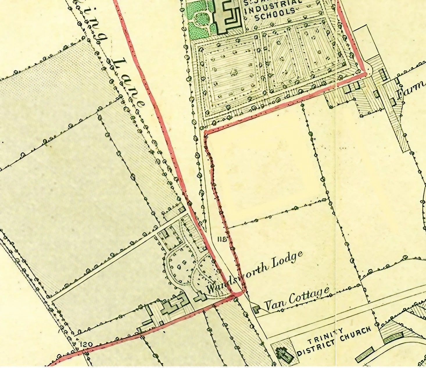
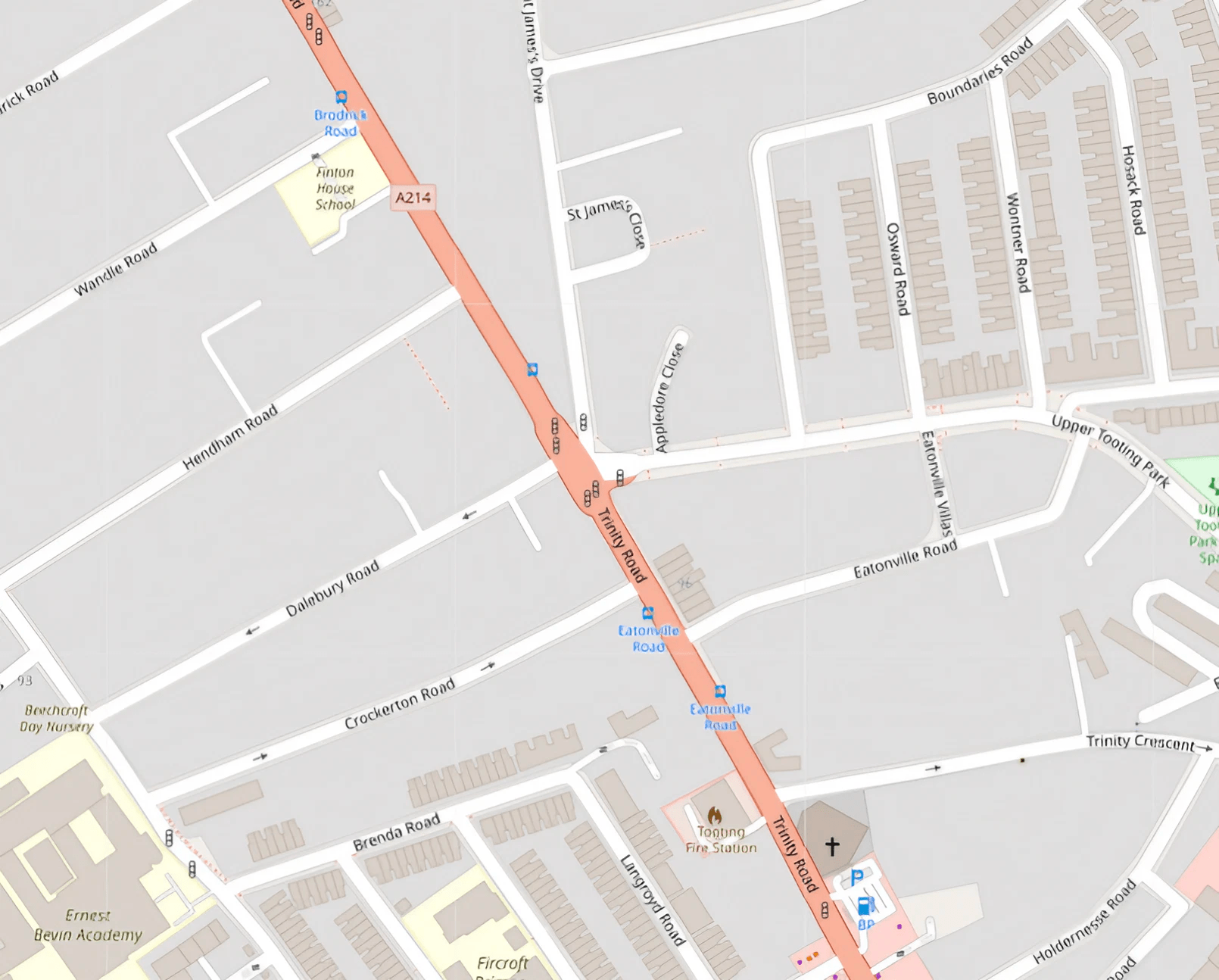
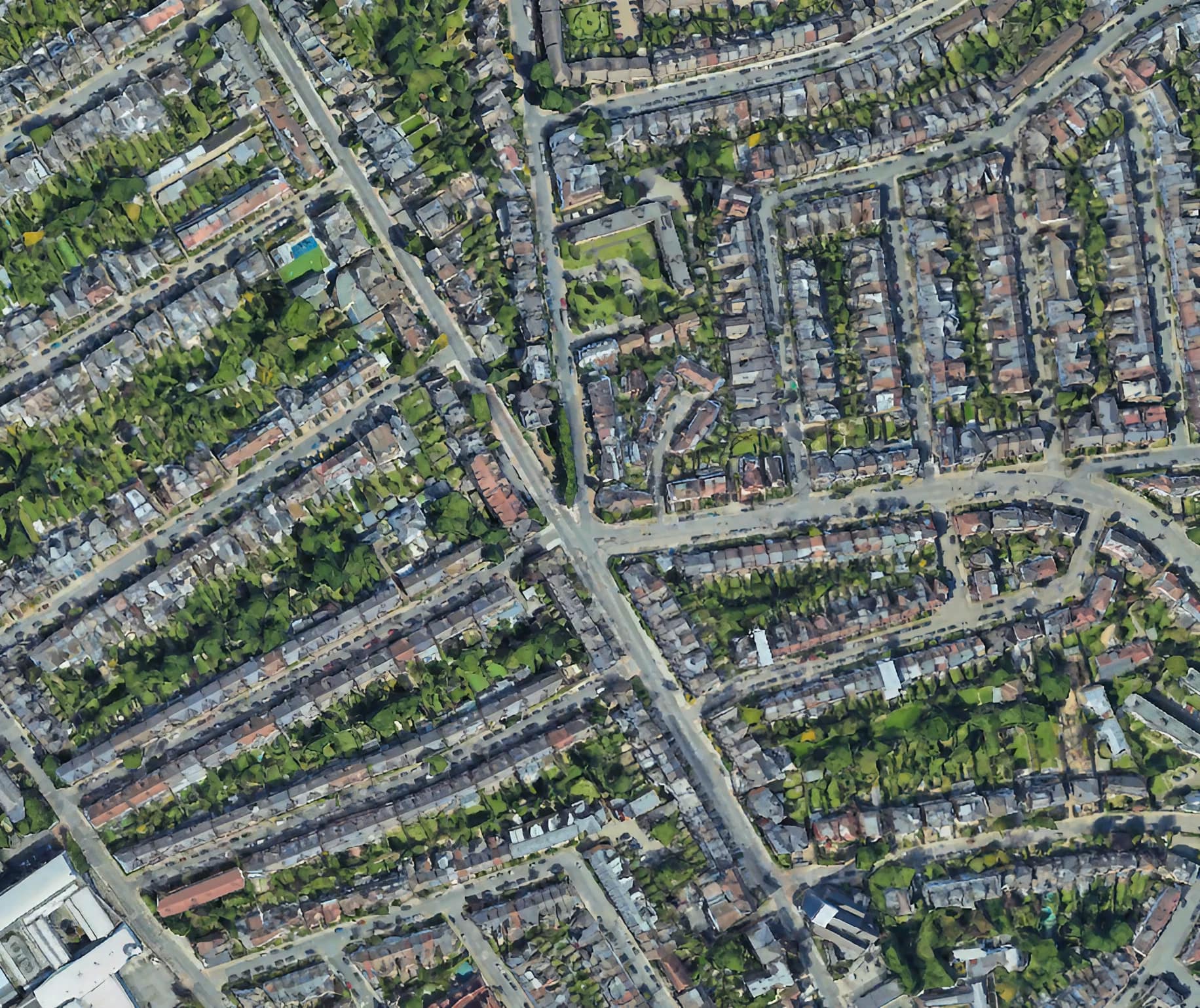
It really is a puzzle. The local archaeologist Nick Fuentes and historian Keith Bailey suggested it might be because the Anglo-Saxons used ancient burial mounds — possibly Iron Age barrows — as a turning point.
Interestingly the barrows are sited very close to but not on the highest point on the Wandsworth Common Massif, which is about fifty yards away to the west near Dalebury Road.
This is not fatal to the theory — on the contrary, most Iron Age burials were positioned below summits or crests in such a position that their silhouettewould be visible against the sky.
Keith Bailey argues that, provided the mounds were at least [10?] feet high, a viewer could stand on the top and see down into the Wandle Valley below.
If the next turning point on the early long boundary marking Battersea-cum-Wandsworth was in that direction, it would be visible. (In KB's view, "Blacan Mor" is likely to be a peat-covered (hence "black") moor between this point and the Wandle ["Noisy Stream"?] below.
[Blacan Mor — black because of burnt furze — swaled.]
If it is accepted that Battersea-cum-Wandsworth was subsequently divided, the mounds again would be the best turning point. (Battersea — the senior partner — is likely to have claimed the whole of the sacred burial mounds as their own.)
Hence the handbrake turn around burial mounds, and the creation of the "sting".

Nothing is said in the 1862 account, but it seems likely that the perambulators were still able to walk uninterrupted in a straight line across McKellar's Triangle to Bellevue Road, then on to the edge of what is now the "Toast Rack" (largely nurseries a this time), directly across the grounds of the Royal Victoria Patriotic Asylum for Girls to the railway line near "Clapham Common Station". (The boys' school — now Emanuel — was built on a little used part of the girls' grounds in 1872.)

[Mid-C19] maps show numerous boundary posts from the corner right the way through "McKellar's Triangle", to the Common, and then right the eay through to today's Spencer Park. Presumably each post could be seen from one to the next.
When McKellar's Triangle was built upon, many of these posts were in the gardens, or on streets (where the streets such as Brodrick and Nottingham crossed the line. The line appeared again on Bellevue (it passed through White Lodge, fairly recently rebuilt).
Are there any posts remaining in these gardens?
And now we are at . . .
[I found this rather lovely photo online somewhere. It would be good to use a locally-sourced image.]
The traditional Wandsworth— Battersea straight-line boundary is crossed/violated in a number of places behind today's "Toast Rack" — it bends and swerves, the result of C19 encroachment by Sophia Sheppard and Magdalen College's tenants (e.g. the Neal famil).
This reflects a complex history in which, many centuries ago, Allfarthing Manor was given a small foothold on the Common — the "Allfarthing Piece".
In an attempt to restrain these encroachments, there are probably more boundary markers in this area than anywhere else around the parish.
"About two hundred yards below the Clapham Common station . . . they crossed the line . . . "


[This suggests the perambulators crossed the RVPA Girls grounds, then crossed the railway line, before turning left along what is now called North Side. The girls' orphanage opened in 1859, but the boys' school was not built until 1872 — it was sold to Emanuel School in 1881, and the first boys arrived in 1883.


[15]
"The wall dividing the Union from the Fishmongers Almshouses . . . "
. . . and from there to the west side of the Union workhouse [15]. The wall dividing the Union from the Fishmongers Almshouses forms part of the western boundary of the parish.

The heavily wooded area to the right may be artistic licence — invented to conceal the Workhouse next door. The wall between them formed the boundary between Battersea and Wandsworth (so the Workhouse was in Battersea).
[16]
Continuing this line across the Richmond Railway [16], into the Wandsworth-road, and from there down a lane on the east side of the Distillery [17] to the Thames, into Battersea-square [1], forms a general descriptive outline of the home bounds of the parish of Battersea.
"After about eight hours the party arrived at the spot from which they started. . . .
The day was everything that could be wished, and there was no disagreeableness during the whole time.
After about eight hours the party arrived at the spot from which they started. Mrs. Walton provided cake and tea for a number of the boys in the evening. Among the party we noticed Mr. Perry, the churchwarden of St. George's, the school-master, Messrs. Poupart, Juer, W. Griffin, Buckmaster, and others.

"Eight hours . . . "
If we were to try to walk the same course today, I wonder how long it would take? How close could we get to the original boundary? How much has the boundary been modified? Have more enclosures taken place?
That's it for the perambulation of Battersea parish, 1862. But just for fun I've tacked on a coda about beating the bounds of a Battersea school in the 1920s . . .

Frivolous, but interesting . . .


[* Old Emanuel Wilfred Scott-Giles (1893— 1982) — an expert on heraldry who served as Fitzalan Pursuivant Extraordinary — is also almost certainly the person ultimately responsible for the rather strange naming of the Fitzhugh Estate, built on what had been part of Wandsworth Common. There's Fitzhugh itself, but also its five eleven-story "point-blocks": Gernigan, Morville, Skipsea, St Quentin, and Woodhall — an oddly medievalist turn for mid-twentieth-century modernist tower blocks. If you want to know more, let me know.]

