← OS map, 1918
Today →
Last modified: 3 October 2026
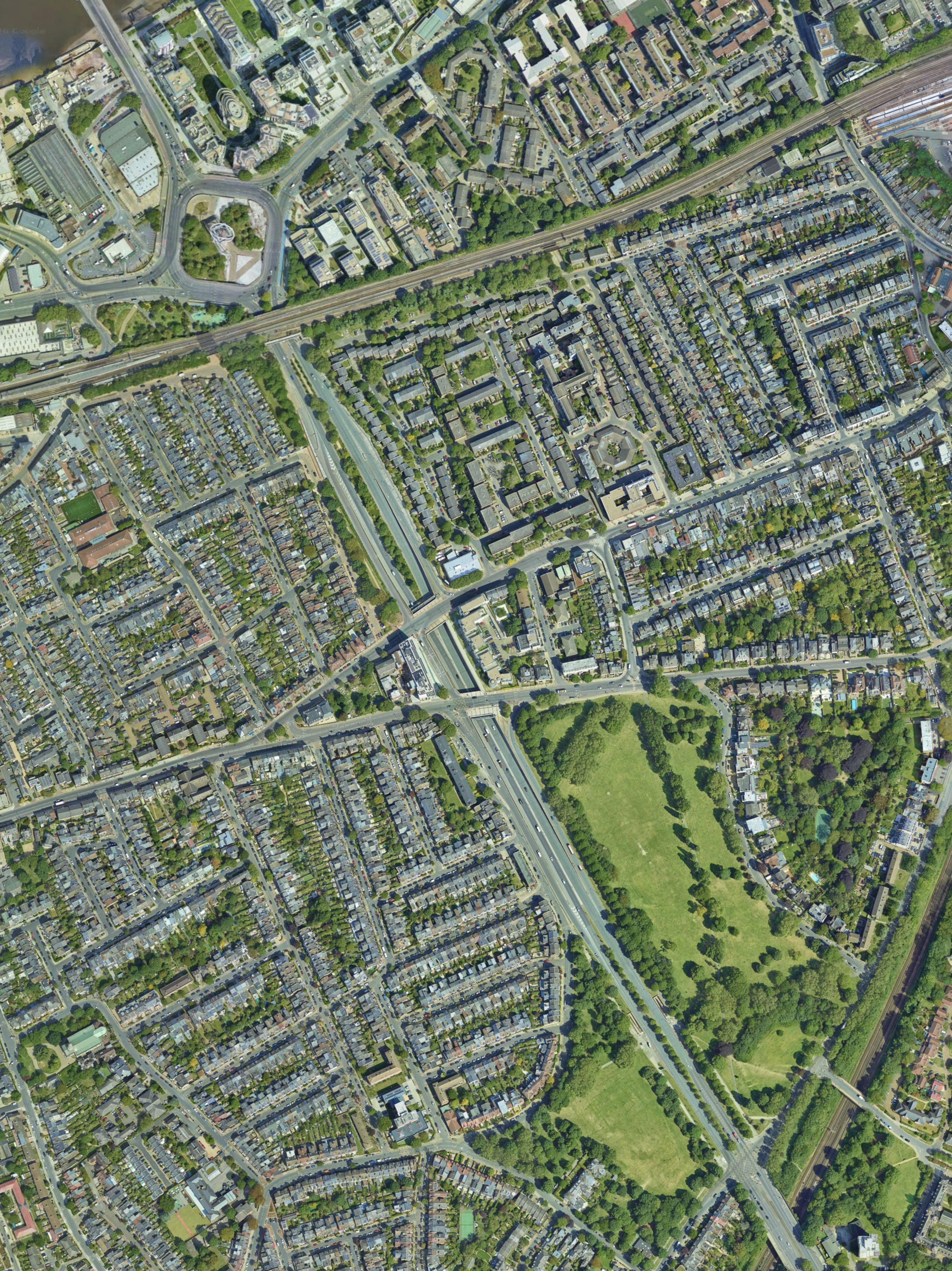
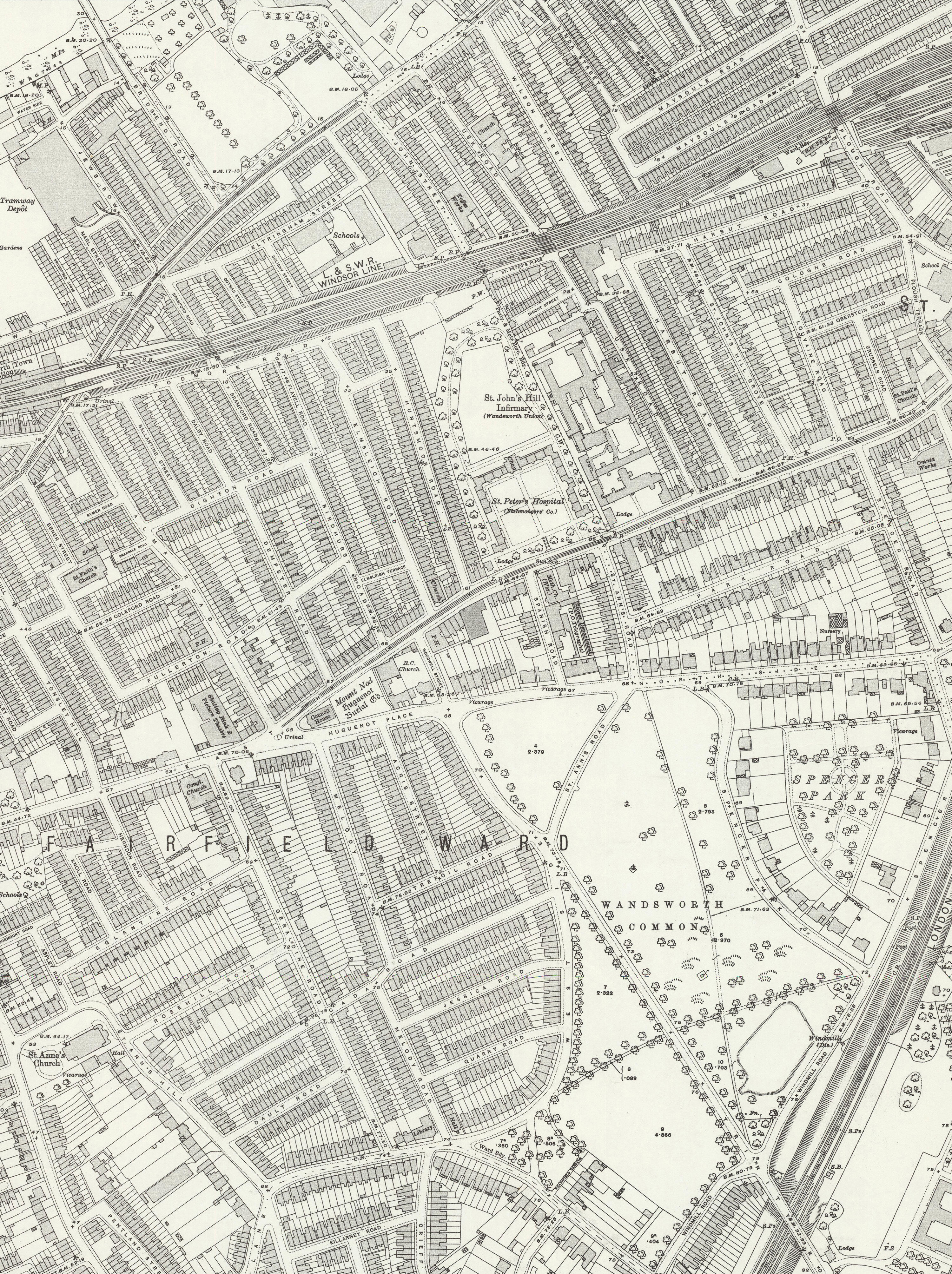
A recent aerial view (Google Earth, June 2024) overlaid on OS 25-inch map, revised 1918 (published 1930s). Use the slider on the map to dissolve between the two views. Both maps are fully explorable in Full Screen mode. You can also view the modern street layout on OpenStreetMap.
I’ve researched and written this account of the extension of Trinity Road to Wandsworth Bridge partly because I don’t actually remember anything about it. I certainly recall what things were like before it existed, and of course I know about it now. But I simply cannot recollect the years in between, while it was being constructed.
For a while, I couldn’t think why not. Surely at the very least I would have remembered the great holes in the ground, the army of workers, the great diggers, the endless flow of lorries carting the gravel and clay away (where did it all go to?). If nothing else, I would surely have been maddeningly inconvenienced by the detours forced on the number 19 bus.
And I’ve found very few photographs to help jog my memory, though here’s one:

Excavating the Trinity Road underpass, c.1969.
But I can’t remember a thing about any of this. In my mind, there’s just before, and there’s after.
Then I suddenly realised why — because these were exactly the years I was away from home, at university or travelling. So this Chronicle is in part an attempt at a kind of retrieval.

Wandsworth from the air. Unknown date, but pre-World War Two (notice the terrace along West Side is still intact — a large part was destroyed by a V1 bomb in 1944). The dense street pattern north of the Common is clearly visible (left). Elam Collection. (Click to enlarge.)
The widening and extension of Trinity Road, the digging of the canyon-like underpass, and the construction of an enormous “Squareabout” near Wandsworth Bridge were begun in 1968 and completed in 1972. The cost was what might seem to us today to be an astonishingly cheap £4 million (no more than the price of some houses in the area today, as we shall see).
This is the concluding chapter in the Trinity Road story — the one about what actually happened, rather than what was planned and then quietly abandoned. The motorway schemes that would have driven multi-lane highways across Wandsworth Common, through Clapham Junction and along the Wandle Valley were all, one by one, dropped. Much of our area escaped remarkably lightly.
But this is only the view from the south of the Common. For those living in the streets between East Hill and the Thames, the road that was built — the Wandsworth Bridge Southern Approach Road, as it was officially known — swept away their homes, their shops and their streets. Around 400 dwellings and seventy shops were demolished. Yet the protests, such as they were, barely registered.

On the eve of demolition. Detail from Bacon’s map of London, 1968, showing the dense street pattern north of Wandsworth Common — East Hill, Trinity Road, and the terraces later swept away by the road scheme. The red dashed line marks the boundary between the boroughs of Wandsworth and Battersea. (Click to enlarge.)
This disproportion — the scale of demolition on the one hand, the near-silence on the other — is what strikes me most about this chapter of the story, and it is why I think it deserves to be better recorded. Perhaps you can help?
A vicarage and other buildings disappeared on North Side, and a pub (the French Horn) and a Unitarian church were lost on East Hill. Between there and the Thames, whole roads and terraces vanished or were greatly changed. South of the railway line: one side of Birdhurst Road, and all of Elmsleigh Terrace and Elmsleigh, Flavell and Geddes Roads. North of the line: York Road, Bridgefield Grove, Marl Street, Coligny and Cotman Streets, and part of Eltringham Street.
[The Squareabout at the bottom of the road deserves its own special study, so we’ll leave that for another time.]
[Ditto the East Hill Estate, built 1926–28 on the site of the St Peter’s Hospital/Fishmongers Almshouses (see the 1918 map above). The Estate survived bombing in World War Two, and remained intact during the construction of the Trinity Road Extension, but it was demolished in stages and was gone by 1981.]
The physical demolition, when it finally came, must have been the culmination of a much longer period of uncertainty and decay. From the late 1930s onwards, when the first Act was passed, through the war years and into the 1950s and 1960s, the streets in the path of the proposed road were probably gradually deteriorating. Did landlords stop maintaining properties? Did families move away?
But all the while, an increasing volume of traffic was percolating through, on its way to and from Wandsworth Bridge. A few weeks ago, Fred Pearce wrote to say:
“When we first moved to Wandsworth, it was to Bramford Rd, in 1979. The old guy who ran the Royal Standard pub close by said he remembered before the Trinity Road extension to the bridge. He said the main route to the bridge then was along Bramford Rd, and such was the traffic trying to get to and from the bridge that you would sometimes have to wait several minutes to cross that road.”
The case for a new road had become overwhelming. But the grandest plans that we’ve looked at in the last couple of months all fell away, leaving the more modest — though still devastating — dual-carriageway and underpass we know today.
As we saw last month, lifting the threat of a motorway cutting across the Common gave a huge boost to the area south of the County Arms. But what happened beyond North Side was very different.
Among the larger buildings lost was part of Eltringham School and the Unitarian Church on the corner of East Hill and Elmsleigh Road — a reminder that it was not only homes and shops that were swept away, but the whole fabric of a neighbourhood.
If you know anything more about these homes and roads, or the school, or this church, please get in touch.
In the 1880s, the recently-named "Trinity Road" was tranquil and unpaved. The boy with his barrow has no idea what's coming.

The top of Trinity Road and West Side, looking towards North Side, probably 1880s. West Side joins from the left, Marcilly Road goes off to the right. Behind the boy's head, invisible in this photograph, must be Ivy House. In the centre distance are The Gables and Lake Terrace. (Click to enlarge.)

The French Horn pub, East Hill, Wandsworth — a Cannon Brewery house. Elam Collection. (Click to enlarge.)
One of the larger buildings to go was the French Horn (aka Ye Olde French Horn, The French Horn Hotel) which had for more than a century been an important local centre - not only for drinking and socialising, but also a coroner's court room and an auction house.
Curiously, the pub had been demolished once before to make way for a new road linking Trinity Road and East Hill, c.1900. But it had been rebuilt just a few yards away to make way for the narrow Woodwell Street — named after its then-landlord, H.A. Woodwell.
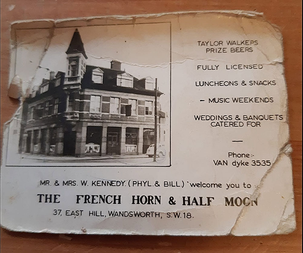
Advert for the French Horn & Half Moon, 37 East Hill — early 1960s? The licensees, Mr and Mrs W. Kennedy, are named on the card. Keni Carrington, writing on the Facebook group Wandsworth and Battersea Memories Live On, identified her father as Bill Kennedy and added: “My bedroom was the turret.” (There's a lovely anecdote about Bill from Hugh Betterton, below.)
Woodwell Street continues today (just about):

Woodwell Street today - a slip road. The Squareabout in the distance. The original French Horn would have straddled the end of this short road. The second version, would have been on the corner on the right of this and today's South Circular. In short, in the middle of the air above Trinity Road underpass. Photo: Google Maps.
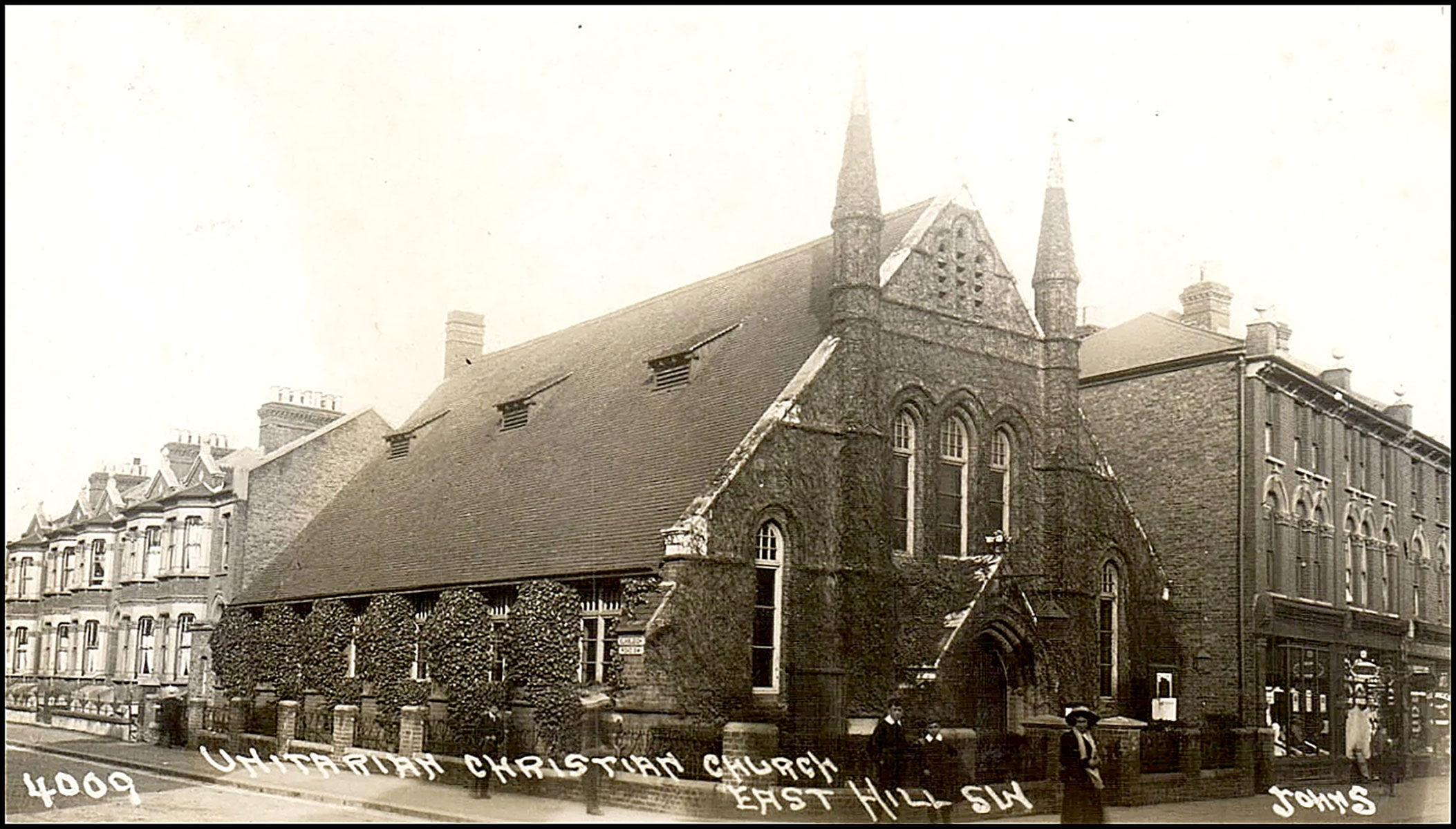
Postcard published c.1912: the Unitarian Church, East Hill, Wandsworth, at the corner with Elmsleigh Road. The church was demolished when Trinity Road was widened and extended, 1967–69. (Click to enlarge.)
Edward Thomas — the poet and essayist who grew up in Wandsworth in the 1880s and 1890s — left a remarkable account of attending the Unitarian chapel with his father as a boy. His memoir of childhood, written around 1912, describes it with the vividness of someone who had not forgotten — or forgiven — a moment of it:
School was not an affliction, but church or chapel or Sunday school was. At an early age I did not go regularly, nor I think did my parents. They were sober reverent people without a creed, though their disbelief in Hell and the Devil almost amounted to a creed.
He [Edward's father] used to try different chapels or different preachers, sometimes taking me with him, more especially when he had become an almost weekly attendant at a Unitarian Chapel. Here from the prickly silence of two hundred or three hundred people I gradually came to feel a mild poison steadily creeping into me on all sides. I never made a friend of any of the boys who attended there. A deathly solemnity filled the chapel.
After the service couples walked to and fro or gathered into knots on the pavement outside. The deathly solemnity was strong enough to cling about the people even there in the sunlight: some of them it accompanied to their one o’clock roast beef or mutton.
But at first the Sunday-school was my particular allowance. I liked singing and liked the melodies of “Jerusalem the Golden” and “Fair waved the golden corn”, and I liked going with all the rest for the annual treat somewhere in Surrey, where I could run about in a wood, become fond of another girl or two (I remember one with a very deep but I think also husky voice), eat bread and butter, watercress and slices of cake and drink tea.
But Sunday was a bad day and this was the worst part of it. That deathly solemnity, whether we respected it or not, was equally thick in the schoolroom. I became accustomed to making a sort of drug of boredom. I did not rebel, but taking this poison became fairly oblivious to the good or evil that befell Jesus Christ, or Servetus*, or myself.
Moreover, I did positively loathe with continuous loathing the trailing with one or more of my brothers along the Sunday streets, in our stiff Sunday clothes and our Sunday hats. I hated these clothes and hats and I felt also that they made me ridiculous in the eyes of others. If the hat was blown off by the wind it was some relief: and I could then stamp on the thing and put it down to the wind and mud. What wonder that I made no friends under this Upas-tree**.
Chapel and Sunday-school were to me cruel ceremonious punishments for the freedom of Monday to Saturday. I have still a profound quiet detestation of Sunday in whatever part of England or Wales it overtakes me, but most of all in London.
There was, however, always one good thing about Sunday, and that was the biscuits, two large oval ones or one of these and two small round ones, which I found on a bedside chair upon awaking.
[* Michael Servetus: the Spanish theologian burned at the stake in Calvin’s Geneva for rejecting the Trinity — this became the central tenet of Unitarianism. ** Upas-tree: notorious source of arrow and dart poisons.]
[The Childhood of Edward Thomas (written c.1912, published posthumously 1938), chapters 31–33.]

Edward Thomas and family, 1890s. Clearly ET was a dominant presence. (Click to enlarge.)
So on this account, there was little to commend Edward to Sundays spent at the Unitarian chapel, other than the singing of hymns, the biscuits — and the annual treat in Surrey, where he clearly had an eye (and an ear) for the girls.
But there was something else there that had a profound effect on the rest of Edward's life, which curiously he doesn’t mention. It was through these visits that he was introduced to the man who would become his mentor, James Ashcroft Noble, and to Noble’s daughter Helen — Edward’s future wife. (I described their meeting at the Noble home, 6 Patten Road, in March 2026’s Chronicles.)
The introduction was made by the Chapel’s minister, William George Tarrant (1853–1928), who clearly recognised something in Edward.
Tarrant served for decades at the Wandsworth Unitarian Church and was long-time editor of the Unitarian magazine The Inquirer. He authored several notable books, including the influential Unitarianism (1912). A hymnologist, he knew a thing or two about words.
He was also very keen on the Huguenots, regularly preaching about their flight from persecution and their search for freedom of worship, themes which resonated deeply with his own Unitarian convictions — so much so that he set up a fine memorial in Mount Nod, the Huguenot Burial Ground, just across the road from his chapel:
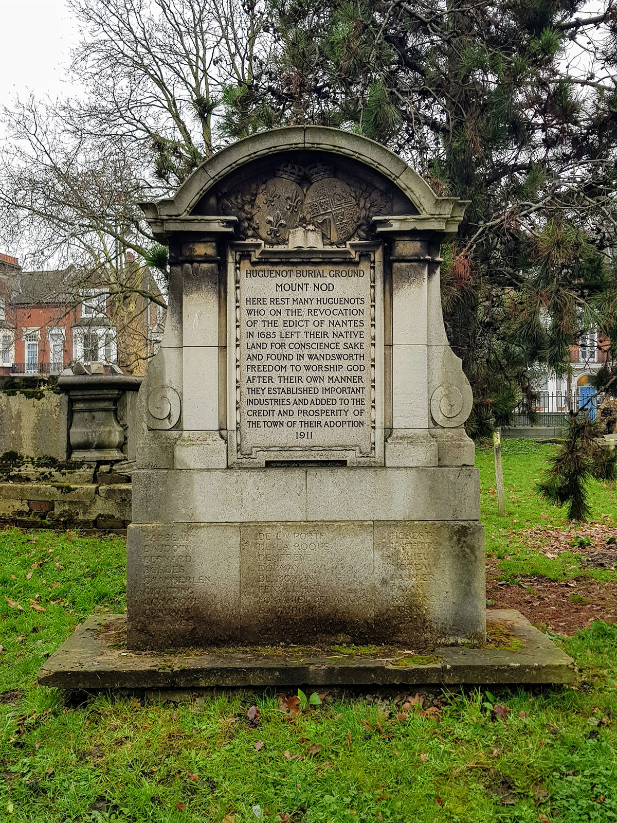
Memorial set up by William George Tarrant in Mount Nod (the Huguenot Burial Ground), 1911. (Click to enlarge.)
HUGUENOT BURIAL GROUND
MOUNT NODHERE REST MANY HUGUENOTS
WHO ON THE REVOCATION
OF THE EDICT OF NANTES
IN 1685 LEFT THEIR NATIVE
LAND FOR CONSCIENCE SAKE
AND FOUND IN WANDSWORTH
FREEDOM TO WORSHIP GOD
AFTER THEIR OWN MANNER.
THEY ESTABLISHED IMPORTANT
INDUSTRIES AND ADDED TO THE
CREDIT AND PROSPERITY OF
THE TOWN OF THEIR ADOPTION.
1911
On the weathered base, notice the names of many prominent Huguenot immigrants. So far as I can tell, these are Barbot, Baudouin, Bernard, Bories, Chamberlen, Chatting, Comarque, De La Porte, De La Roque, Delaparelle, Fourdrinier, Grolleau, Montoileu, Paggen, Poumies, Savigny.
Although the cemetery is associated with the Huguenots, Dorian Gerhold notes that “by no means all those buried there were Huguenots” (Wandsworth Past, p.90). It was enclosed from the Common in 1680, just before Huguenots arrived in Wandsworth. (The Revocation of the Edict of Nantes, which deprived French Protestants of religious and civil liberties, was in 1685.) Dorian goes on to say that “It narrowly escaped destruction in the 1960s for a slip road from Trinity Road.”
So far, I have focused on some of the larger buildings destroyed by the new Trinity Road, but the road scheme mainly required the demolition of a large number of terraced streets between East Hill and the Thames.
A Wandsworth Council paper of November 1967 recorded the clearance of “400 dwellings and seventy shops.” Local historian Nigel Black, whose authoritative article “The curious tale of Wandsworth’s motorways” (Wandsworth Historian, no. 106, 2018) is the essential account of the wider motorway schemes, confirmed this figure independently by comparing maps at Wandsworth Heritage Service and counting the missing houses road by road. His detailed findings are set out below.

Detail from Bacon’s map of London, 1968. (Click to enlarge.)
It's worth reflecting on the scale of the destruction. As Nigel points out, it was broadly comparable to the proposed Battersea section of Ringway 1, where some 1,750 homes were at risk — and which provoked fierce, sustained, nationally-reported opposition. The Trinity Road demolitions produced barely a murmur by comparison. Why? Perhaps because the scheme had been anticipated for so long that it had ceased to feel remarkable. Perhaps because the area between East Hill and the river was not, in the 1960s, regarded as fashionable or “worth saving” in the way that parts of Battersea were. Or perhaps simply because nobody was keeping count.
Whatever the reason, the people who lost their homes deserve to be remembered. Here, street by street, is what went:
| Street | Numbers demolished | Count |
|---|---|---|
| East Hill | N 28–54, S 27–37 — and a Unitarian Church | 20 |
| Birdhurst Road | E 2–68 | 34 |
| Elmsleigh Terrace | 1–5 | 5 |
| Elmsleigh Road | W 1–33, E 4–116 | 74 |
| Woodwell Street | About 12 properties | 12 |
| Wandsworth Common North Side | 82–90 | 10 |
| Flavell Road | E 1–39, W 2–42 | 41 |
| Coligny Street | E 2–20, W 1–17 | 19 |
| Eltringham Street | N 34–76, S 19–31 | 29 |
| Bridgend Road | W 2–42 | 21 |
| Cotman Street | 1–26 | 26 |
| Bramford Road | E 1–23, W 2–18 | 21 |
| York Road | N 264–294, S 383–491 | 68 |
| Total | 380 |
Source: Nigel Black, compiled from Wandsworth Council papers (council minutes, 15 November 1967) and comparison of pre- and post-construction maps at Wandsworth Heritage Service. Huntsmoor Road is not included, as it was still shown on the 1971 map, presumably awaiting a separate redevelopment scheme. Thanks, Nigel!

Elmsleigh Road, Wandsworth — 74 houses were demolished for the Trinity Road scheme, making this the single largest loss. Johns series. Elam Collection. (Click to enlarge.)

Birdhurst Road, Wandsworth — 34 houses on the east side were demolished for the Trinity Road scheme. Elam Collection. (Click to enlarge.)

Coleford Road, Wandsworth — a second view. Johns series. Elam Collection. (Click to enlarge.)

Dempster Road, Wandsworth — a second view. Johns series. Elam Collection. (Click to enlarge.)

Dighton Road, Wandsworth. Johns series. Elam Collection. (Click to enlarge.)

Fullerton Road, Wandsworth, with St John’s Church visible at the end. Johns series. Elam Collection. (Click to enlarge.)

Huntsmoor Road, Wandsworth. Johns series. Elam Collection. (Click to enlarge.)
Do you have photographs of the streets prior to demolition? Please send them to me and I'll add them, together with your recollections.
Here’s one family’s story about lives changed by the new road.
My school-friend Hugh Betterton has featured a number of times already in these Chronicles. When he was in his mid-teens, he and his family were moved out of their home on West Side, not because it stood in the way of the new road but because sufficient land was needed for a works office. In 1967 they were moved to a flat in Morville House on the Fitzhugh Estate. He sent me this photograph of his sister Janet outside the family home before the war:

Janet Paul (née Betterton), aged about 14 months, outside the family home at 26 West Side, Wandsworth Common, 1933. (Click to enlarge.)
When I contacted Hugh to confirm some details about this photograph of Janet, he told me he was just leaving to attend her funeral. Janet Paul died on 11 May 2026. In 2024, I had corresponded with her about her memories of the Common and have now made a web page to record this. Please visit Janet Paul’s memories of the Common in wartime.
The terrace today:
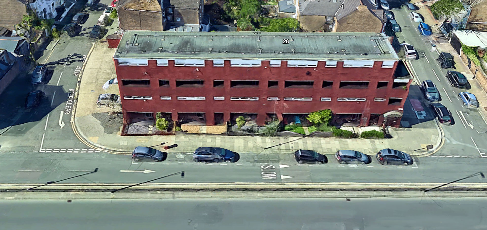
The site of the Betterton family home today. While work was continuing on the Extension, temporary works offices occupied the site of the short row of houses, 26–31 West Side, between Trefoil Road and Cicada Road. When the project finished, the site offices were themselves demolished and a startling block of maisonettes erected.
Hugh has since written with some further recollections:
The GLC offered my parents a couple of other places to live before we moved to Morville House on Fitzhugh Estate. My mother was quite exercised about living somewhere ‘nice’, which bothered her somewhat. I was in France on holiday (post A-level) when the offer came through. My father agreed to accept it. We finally moved in September ’67 when I had just started work at Metal Box Co in Baker Street.
I had a party in the West Side house just prior to its demolition; the police came along thinking it was squatters moving in! I watched the house come down along with the rest of the block. My father left his bike in the cellar and couldn’t recover it!
The underpass build was very noisy for those still living on the northern bit of West Side, as well as those in Alexander Court. I believe the residents had their rents reduced for the duration, as compensation.
I used to go to the French Horn, as well as Tiger’s Café, which was to the south of the French Horn. A memory from the French Horn is that I had a dart stuck in my leg from a dodgy throw at the dart board; Bill put some Scotch onto a hankie to treat the bleed! Tiger’s was a great greasy spoon selling big bacon sandwiches and builder’s tea; Sunday mornings when I played football for West Side FC was our meeting place before games. The steam and smoke mingled almost invisibly.
The streets leading to the bridge were demolished hastily, I recall, and some of the residents tried to salvage some things from the wreckage but were chased off by guard dogs.
Like you, Philip, being away at the time meant I didn’t see very much of the build — as well as the widening of Trinity Road, which seemed to shift the traffic jams from the bottom of Wandsworth Bridge to the Trinity Road junction with Earlsfield and Windmill Roads!
Hugh Betterton, June 2026
Graham Jackson (our expert on the history of Trinity Fields), who grew up nar West Side, writes:
Thanks for your account of the underpass to Wandsworth Bridge. As I think I have told you my parents attended St Johns Hill Methodist Church. I remember Birdhurst Road if only because they had friends living there. Whether or not their house was demolished or even if it was not, I am unsure, but the underpass would have surely blighted the value of properties on the western side of the road.
The Trinity Road link with Wandsworth Bridge was very much needed. It has certainly helped with the traffic flow from Fulham to Wandsworth although in a strange way Wandsworth Bridge leads nowhere in particular insofar, although I might be wrong, that the traffic travelling across it is far less than gets jammed crossing Putney Bridge in both directions. However today the underpass is so very much part of the landscape that it is almost inconceivable to imagine what it was like before.
I think I have told you, coming home from scouts one evening from the church mentioned above, I tried to turn into Marcilly Road far too quickly from North Side hit the kerb and was thrown onto Wandsworth Common. Fortunately after a soft landing I was no worse for wear, but I can always remember where Marcilly Road ( the common part of it was that is). Interesting to know where all the spoil from the excavations for the underpass landed up.
Graham Jackson, June 2026
The 1871 Wandsworth Common Act had protected the Common as a whole “in perpetuity” — but it always allowed for exchange: land taken for a public purpose could be compensated by land added elsewhere. The road scheme required a strip of Common for the additional road width. In return, four areas were added to the Common:
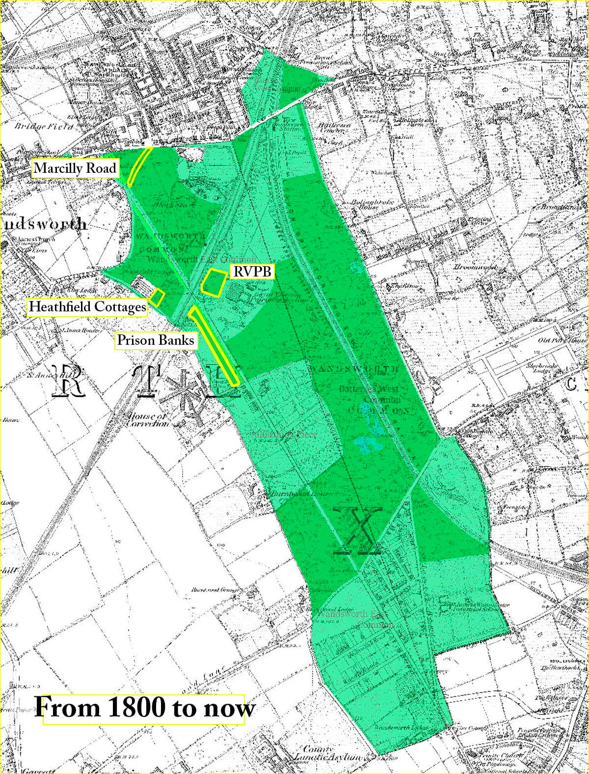
Two centuries of change: Wandsworth Common today shown within its likely extent in the late eighteenth century. The four areas outlined in yellow were returned to the Common to compensate for losses due to the widening of the northern end of Trinity Road in the late 1960s.
1. — A long strip of the Prison Banks land in front of the prison, released by the Home Office. As a result, Heathfield Avenue (the former approach road to the Prison) was cut short, and the size of Neal’s Nursery much reduced.

The Prison Banks today — over 50 species of wildflower have been recorded on this strip of land, released by the Home Office as part of the Trinity Road exchange and now one of the richest corners of Wandsworth Common. Roy Vickery of the South London Botanical Institute leading a wildflower walk there, June 2023. (Click to enlarge.)
2. — The section of Marcilly Road (also known as St Ann’s Road) that crossed the Common from North Side, is a green fossil — grassed over but its avenue of trees remains. (This also meant that the small triangular area previously detached from the main body of the Common was now reunited with it.)

The ghost of Marcilly Road, now grassed over and restored to Wandsworth Common as part of the Trinity Road exchange. The avenue of trees that lined the old road is still clearly visible from the air. Trinity Road itself runs along the left edge. Aerial photograph: Google Earth. (Click to enlarge.)
3. — An acre or so in front of the Patriotic Building was also coopted, even though it was entirely detached from the rest of the Common.
4.— The rear portions of the gardens of Heathfield Gardens, whose cottages had originally been earmarked for full demolition. A public campaign and national press coverage saved the terrace itself; only the rear gardens were taken.

Heathfield Gardens cottages, dilapidated and expecting demolition, 1969.
Having been reprieved, the run-down cottages have gone on to become among the most sought-after addresses on the Common:

A similar view in 2020. Notice the price for this single cottage is just £5000 short of the entire cost of the Trinity Road development, c.1970.
This account is necessarily based on maps, council minutes and newspaper archives — the official record. What it lacks is the human record: the memories of the people who actually lived in Elmsleigh Road or Flavell Road or Coligny Street, or who watched their neighbourhood change around them during those long years of uncertainty.
If you — or your parents or grandparents — lived in any of the streets listed in the table above, or remember the area before and after the demolitions, I would very much like to hear from you. These are the stories that do not get into the official record, and they matter.
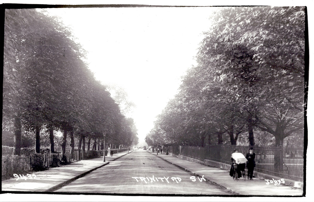
View northward along Trinity Road around 1910, from near the County Arms. Today this stretch is a dual-carriageway. Photo: Elam Collection. (Click to enlarge.)
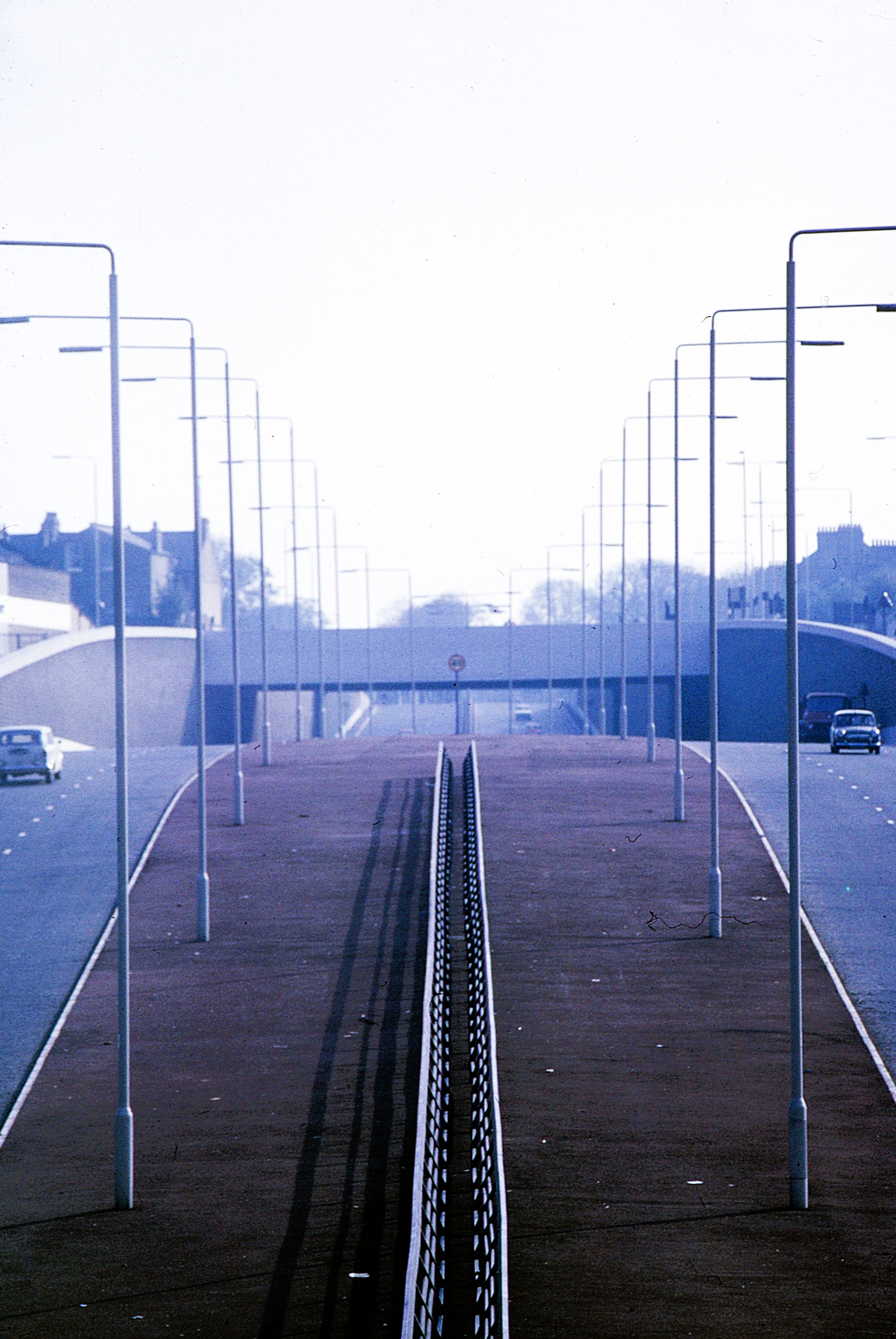
The new Trinity Road, December 1970. Photo: Alex Szczepanski. (Click to enlarge.)
As I may have said before, I’d love eventually to write a bit-by-bit history of Trinity Road as a whole. In the meantime, here’s a nice aerial view for you to scroll up and down:
Trinity Road from Wandsworth Bridge (top) southward to beyond Wandsworth Common (bottom). The Squareabout is clearly visible at the northern end; the railway crossing and the Common stretch out below. Aerial photograph: Google Earth, 2024. Scroll to explore. — Open full-resolution version
Warm thanks to Hugh Betterton and his sister Janet Paul, and Graham Jackson, for their memories of West Side; to Nigel Black for giving me access to his meticulous street-by-street research, and to Alex Szczepanski for his fine photographs of the area under construction.
I would also like to thank Keith Bailey, a regular correspondent for some years, for demonstrating the importance of building history. His Bridge Field, Wandsworth, from Medieval Open-Field strips to Victorian suburb (Part One, 1600-1841; Part Two, 1841-1914), May 2023, is an extraordinarily detailed study of the area in question (including the "Tonsleys" to the west), is a tour de force. It really must be published.
So many more stories still to tell. But that’s all for now, folks!
Send me an email if you enjoyed this post / want to comment on something you’ve seen on the site / would like to know more — or just want to be kept in touch.
If you would like to receive notifications of new Chronicles, let me know . . .
Philip Boys (“History Boys”)
June 2026
— Friends of Wandsworth Common
— Wandsworth Historical Society
