
In last month's Chronicles (July 2025) I mentioned how Thomas Hardy became acquainted with the great Victorian natural scientist Thomas Henry Huxley at glorious garden parties at Knapdale, not far from Wandsworth Common at today's Tooting Bec.

Huxley is often referred to as "Darwin's Bulldog" for his robust defence of the theory of evolution by natural selection, then under seige. Huxley's reputation was chiefly made by his apparent* trouncing in a debate debate at Oxford in 1860 of Battersea-born ("Soapy Sam") Wilberforce (1805-1873), Bishop of Oxford and son of the anti-slave-trade MP William Wilberforce.
Widely known as "Soapy Sam" (thanks to what Disraeli memorably called his "unctuous, oleaginous, saponaceous" manner), Wilberforce was born "between the Commons" in Broomfield House (renamed Broomwood House, hence Broomwood Road).
[* I say "apparent" because the reality is rather different. At the time, both sides were able to claim victory. Wilberforce was a much more intellectually capable opponent than posterity generally admits. If you want to know more, email me and I'll send some good references.]

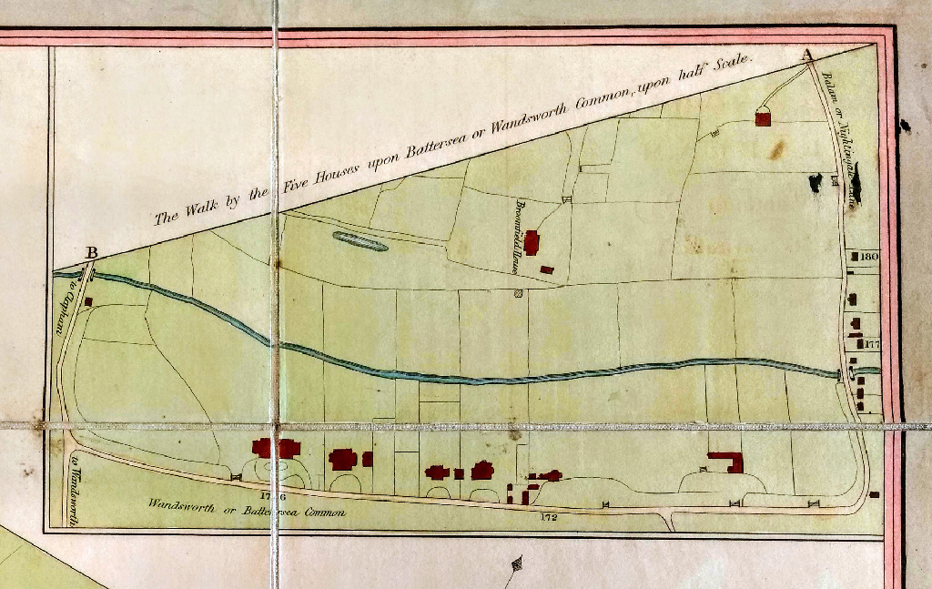
Some time ago, I discussed the possibility that Samuel had participated as a boy in Beatings of the Battersea Bounds. Here's a map of the 5 Houses on Bolingbroke Grove — and nearby Broomfield House, where Wilberforce was born:
A couple of years before the Hardys arrived on Trinity Road, Alexander Macmillan published Huxley's pioneering work of popular education, Physiography: An Introduction to the Study of Nature.
Like many of his most brilliant contemporaries (such as the mathematician-engineer Henry Moseley, and our local hero John Buckmaster), Huxley was devoted to improving educational opportunities for the working and lower middle classes, not just the elites of the day.
I don't know whether Thomas Hardy knew and read Huxley's book, let alone was influenced by it, but it seems to me that it resonates with Hardy's own outlook: the awesome powers of Nature acting not just at the macro-level — planetary, continental or national — but also at the everyday and seemingly insignificant levels. In short, that the general and universal is best understood through the individual and the local.
In place of Hardy's Wessex microscosm, Huxley's focus is on the Thames Valley. (Huxley was born not far away in Ealing, West London.)
It was necessary to illustrate my method by a concrete case; and, as a Londoner addressing Londoners, I selected the Thames, and its basin, for my text . . .
In very broad, but, I hope, accurate, outlines, a view of the "place in nature" of a particular district of England, the basin of the Thames; and to leave upon their minds the impression that the muddy waters of our metropolitan river; the hills between which it flows; the breezes which blow over it; are not isolated phenomena, to be taken as understood because they are familiar . . .
He follows this with a sentence that is dangerously long but worth unpicking:
On the contrary, I endeavoured to show that the application of the plainest and simplest processes of reasoning to any one of these phenomena, suffices to show, lying behind it, a cause, which again suggests another; until, step by step, the conviction dawns upon the learner that, to attain to even an elementary conception of what goes on in his parish, he must know something about the universe; that the pebble he kicks aside would not be what it is and where it is, unless a particular chapter of the earth's history, finished untold ages ago, had been exactly what it was.
In short, to learn about the Big Picture — the universe, ultimate causes, or long chapters of the earth's history — Huxley urges us to look up close at what is immediately at hand, that we can perceive directly: at what occurs in our parish, or in the existence of a pebble. I like that. It could act as the epigram for these Chronicles.
You will not be surprised to hear that Wandsworth Common and surrounds feature prominently in Physiography (at least in the first edition of 1877). Let's look at a few examples.
Here's one.
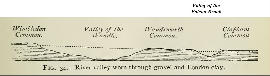
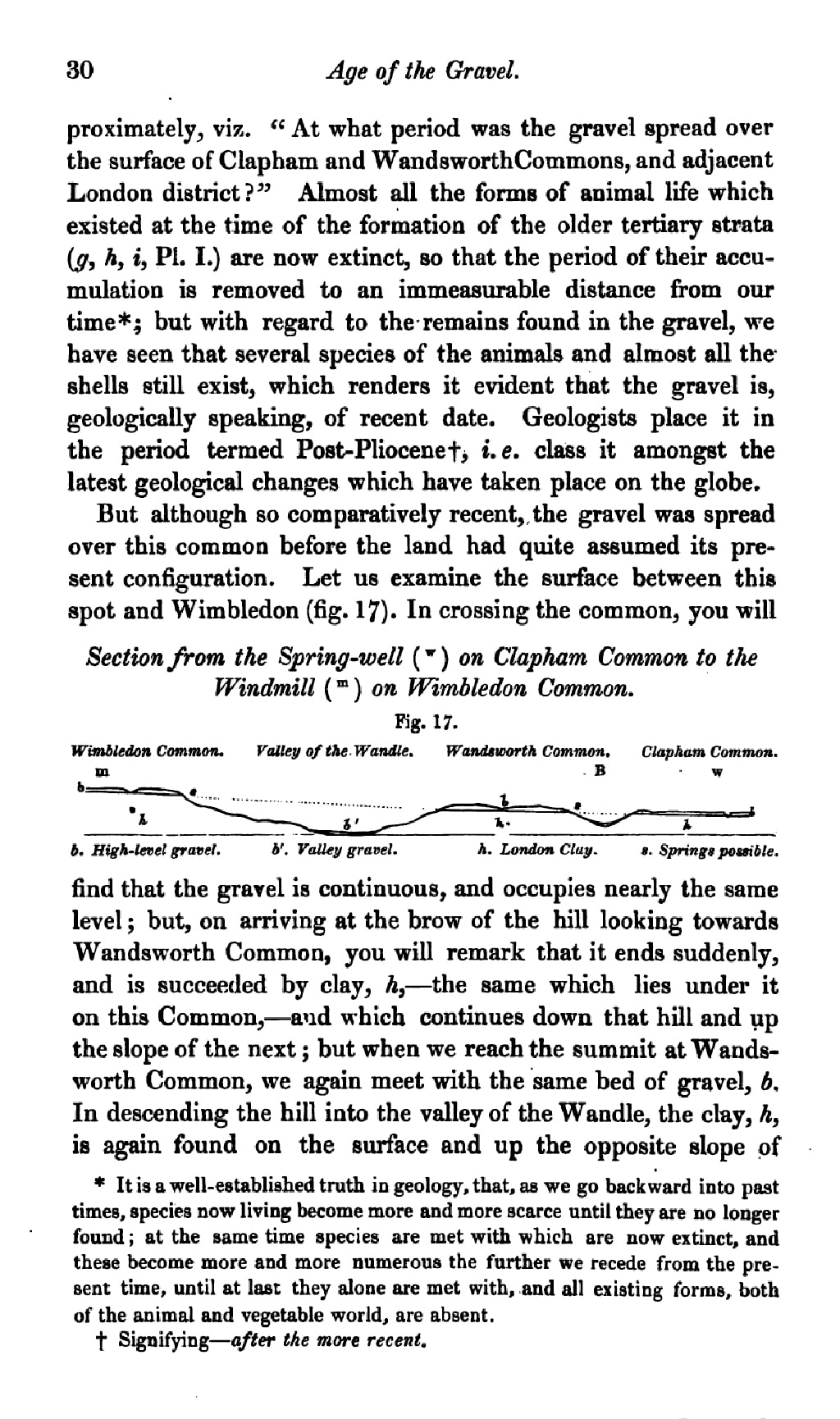
Here it is seen that the surface of Wimbledon Common is covered by a bed of gravel spread over the London clay. On descending from the summit of the Common to the valley of the river Wandle, the gravel is seen to be abruptly cut off and succeeded by the underlying clay; but, on going up the opposite slope of the valley, the gravel again appears, at about the same level, and covers the surface of Wandsworth Common; and similarly the gravel will be found on the surface of Clapham Common.
[Huxley, Physiography, p.139]
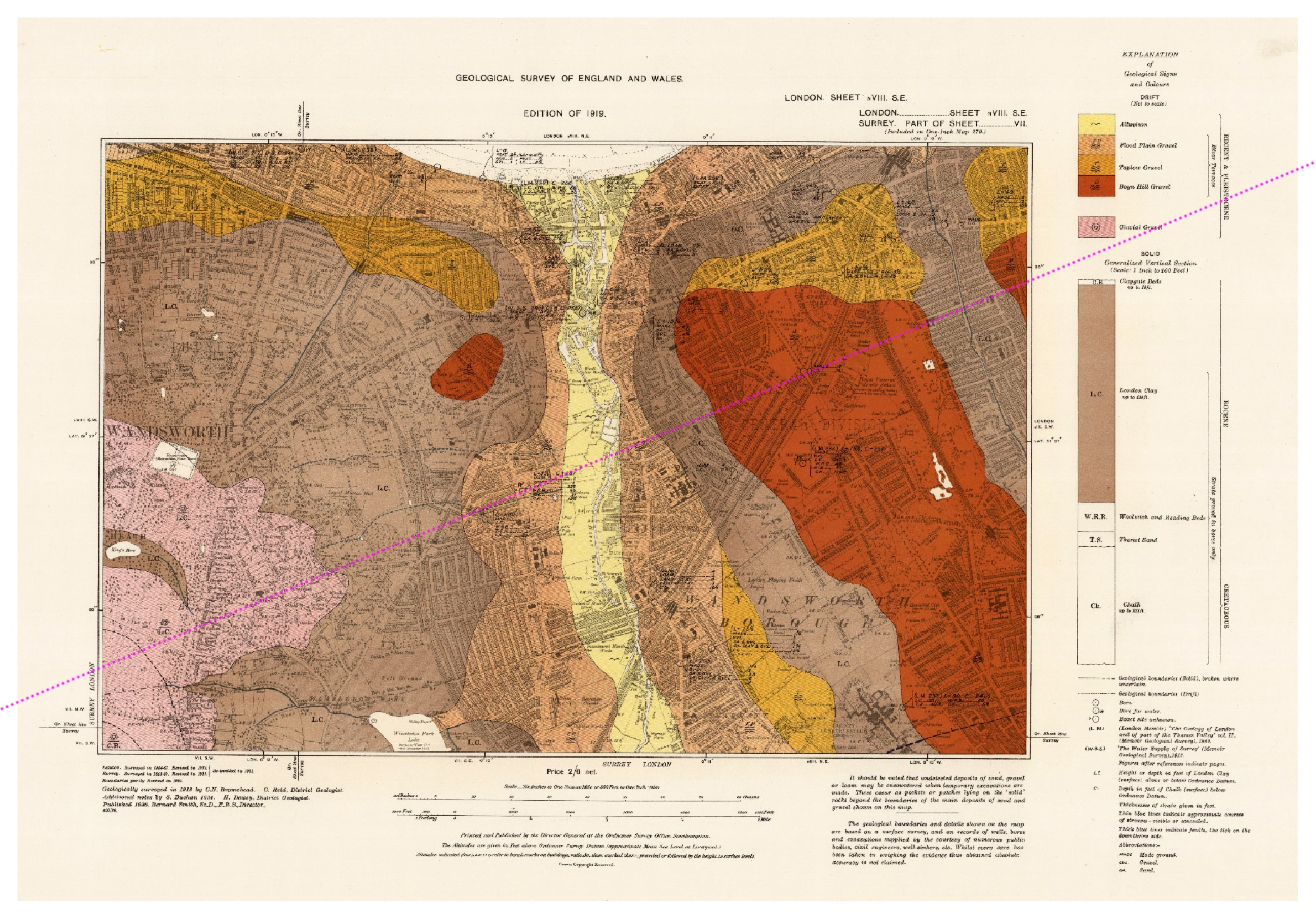
To help you visualise this, I've drawn just such a line on an Ordnance Survey Geological Map from 1913. The yellow strip in the middle is the alluvium alongside the River Wandle, with the gravel mass of Wandsworth Common, tinted chestnut-brown , immediately to its east.
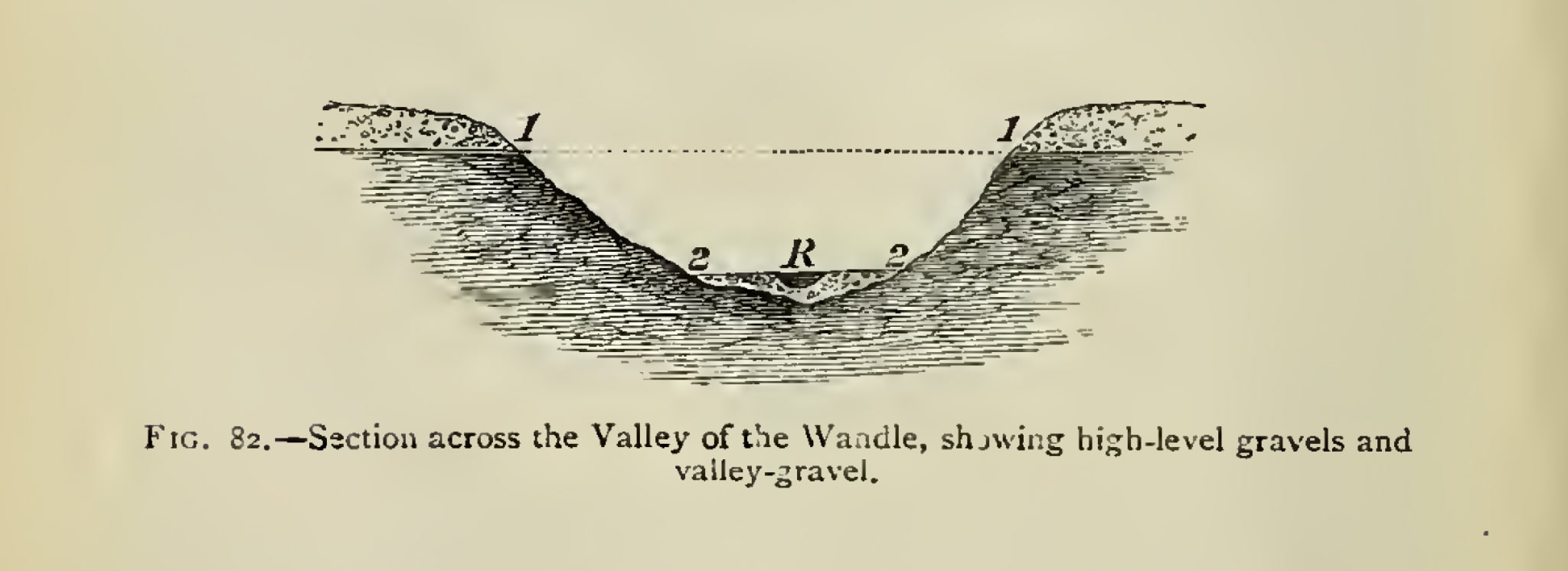
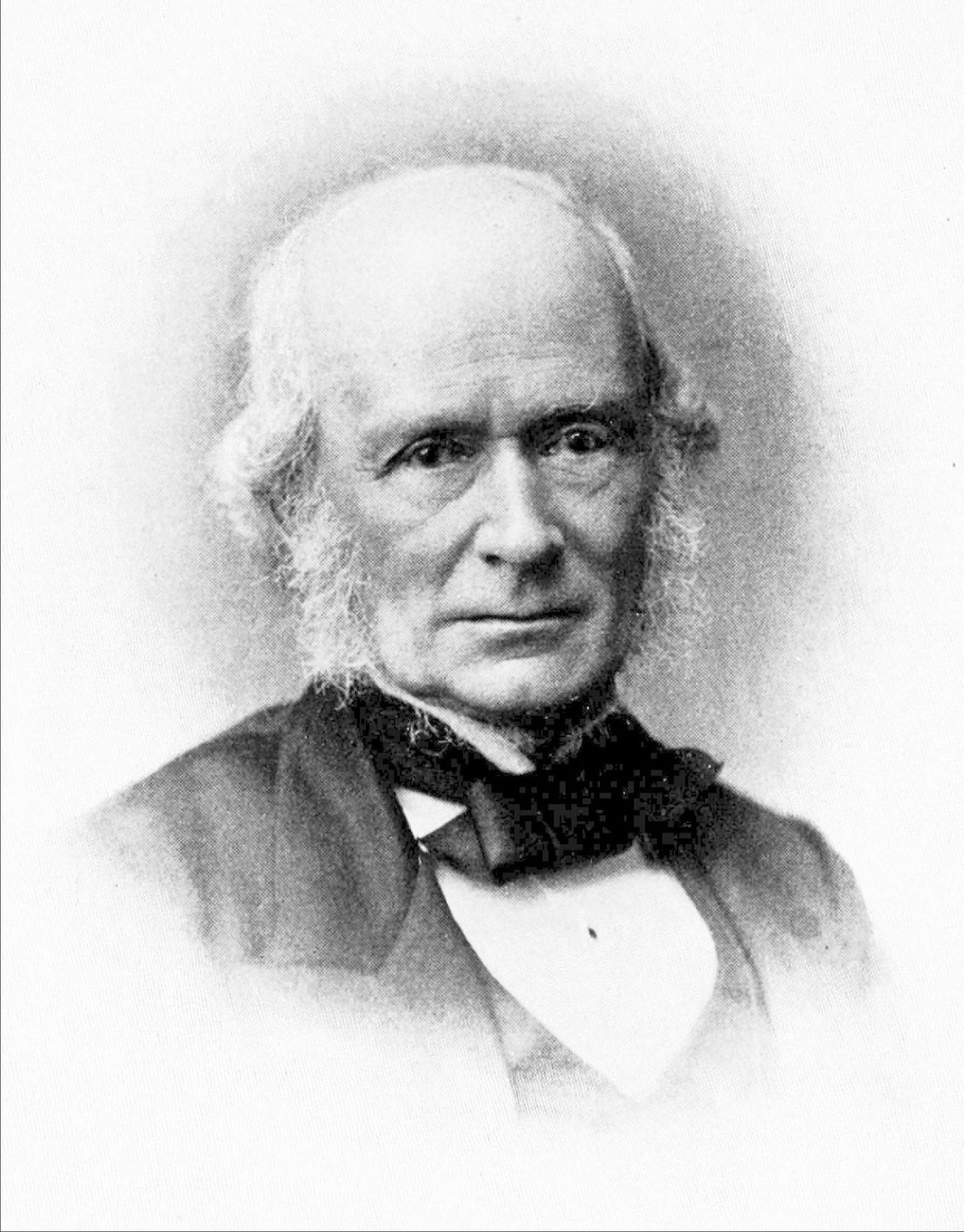
In fact, Huxley has borrowed this cross-section (indeed much of his explanation of local geology and landforms) from the great Clapham-born geologist Joseph Prestwich (1812-1896).
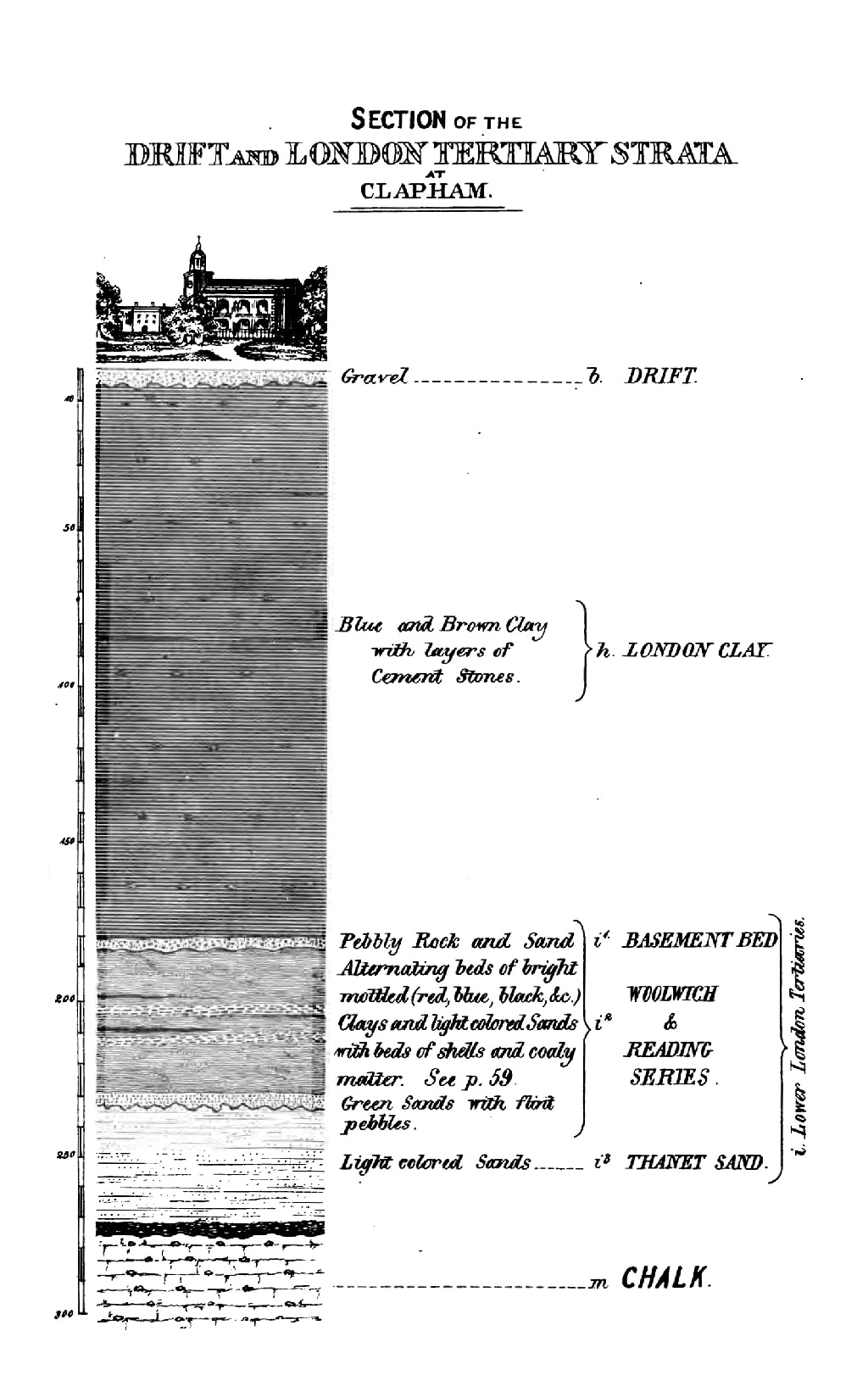
Here's a page from Prestwich's marvellous The Ground Beneath Us, Its Geological Phases and Changes: Being Three Lectures On the Geology of Clapham and the Neighbourhood of London Generally (1854-1856).
Joseph Prestwich's lectures were given to the Clapham Athenaeum, a club founded in 1841 as the "Clapham Literary and Scientific Society" to discuss "subjects of general interest among the young men resident in the neighbourhood".
[Did young women, such as Henrietta Wollaston, attend too? I don't know. Minutes of its "Proceedings" are held by the Lambeth Archives, so there may be an answer there. See National Archives.]
At this time, Prestwich was a wine merchant in the City, but such was his absorption, energy, and brilliance that he went on to become Professor of Geology at Oxford University.
Here he is in (much) later life:
[I had firmly intended to write something more about local-boy Joseph Prestwich, for example about about his young life in the area, which he records in an entertaining memoir — about his schooling, his walks along Lavender Hill, his time in a Wandsworth school, and his love of the Wandsworth Fair. But I became so absorbed in the research that I will have to delay saying anything more for another time. In the meanwhile, have a look at his Wikipedia entry .]
Here's another example from Huxley's Physiography (p.137). It shows how the valley betwixt and between the Commons was formed by millennia of erosion by the mighty Falcon Brook:
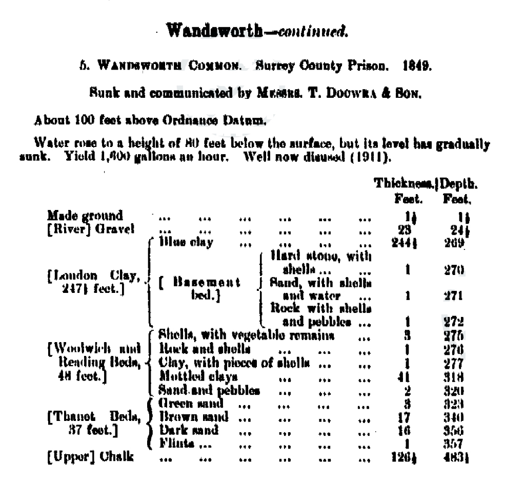
Prestwich and Huxley also take us deep underground, using discoveries from the latest boreholes being dug around the capital. These were being dug not for scientific reasons, but because of the need to provide water to the houses and new institutions (such as Wandsworth Prison) being built in the area. Thanks to his geological prowess, Prestwich became the leading authority on water-bearing strata in the London area.
Here is Prestwich's remarkable cross-section of the ground beneath Holy Trinity Church, on Clapham Common:
Before we leave Huxley for a while, I just can't resist showing his illustration of the mammoth. Cuddly, isn't it.
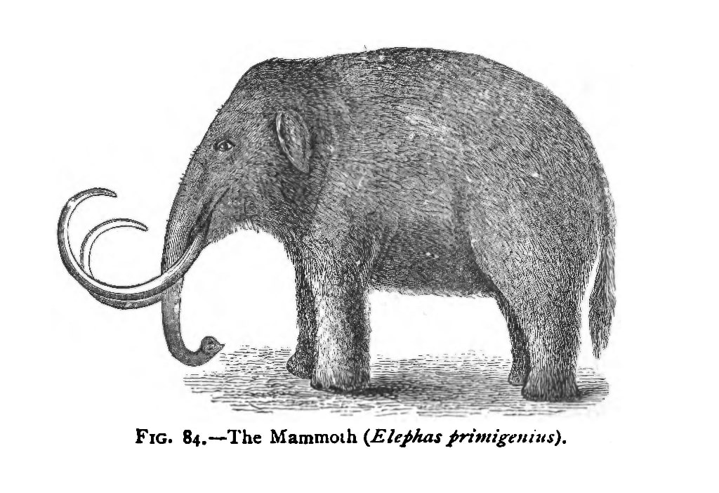
Again, it's an image borrowed and adapted from Prestwich.
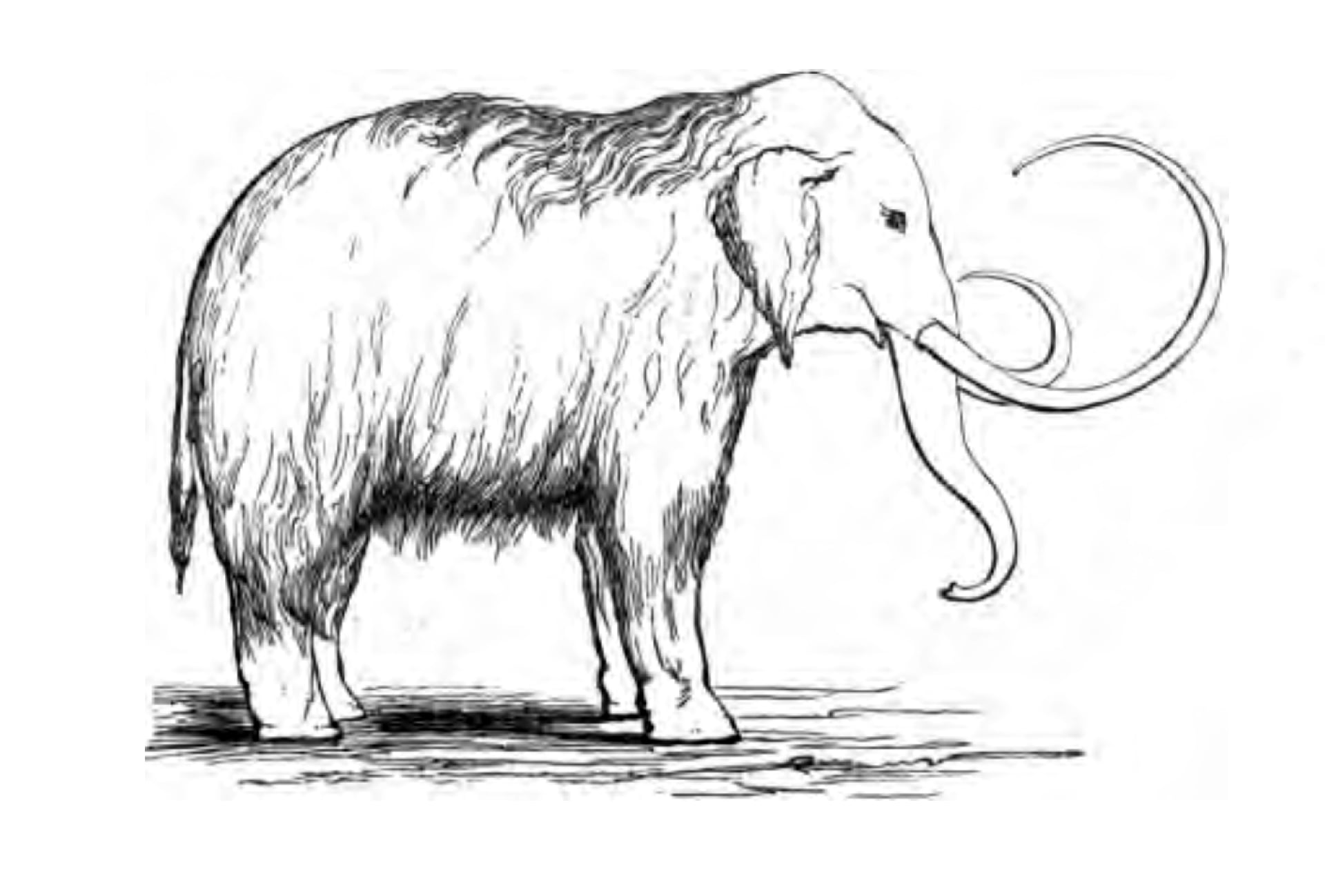
These reminded me of the first-ever image I used in the first-ever talk I gave about Wandsworth Common, by Zoom:
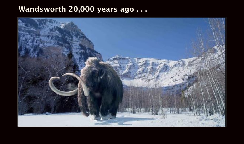
And here's another impression of who you mght have bumped into when you were walking your dog over the Common in winter:
I wasn't being entirely serious. But then I suspect neither was the author of this piece in the local Guardian in 2013, which starts "Some of the world's leading mammoth experts are flocking to Wandsworth after construction workers digging the controversial Thames Tunnel unearthed prehistoric teeth, bones and tusks."
"Flocking to Wandsworth"? Really? Why?
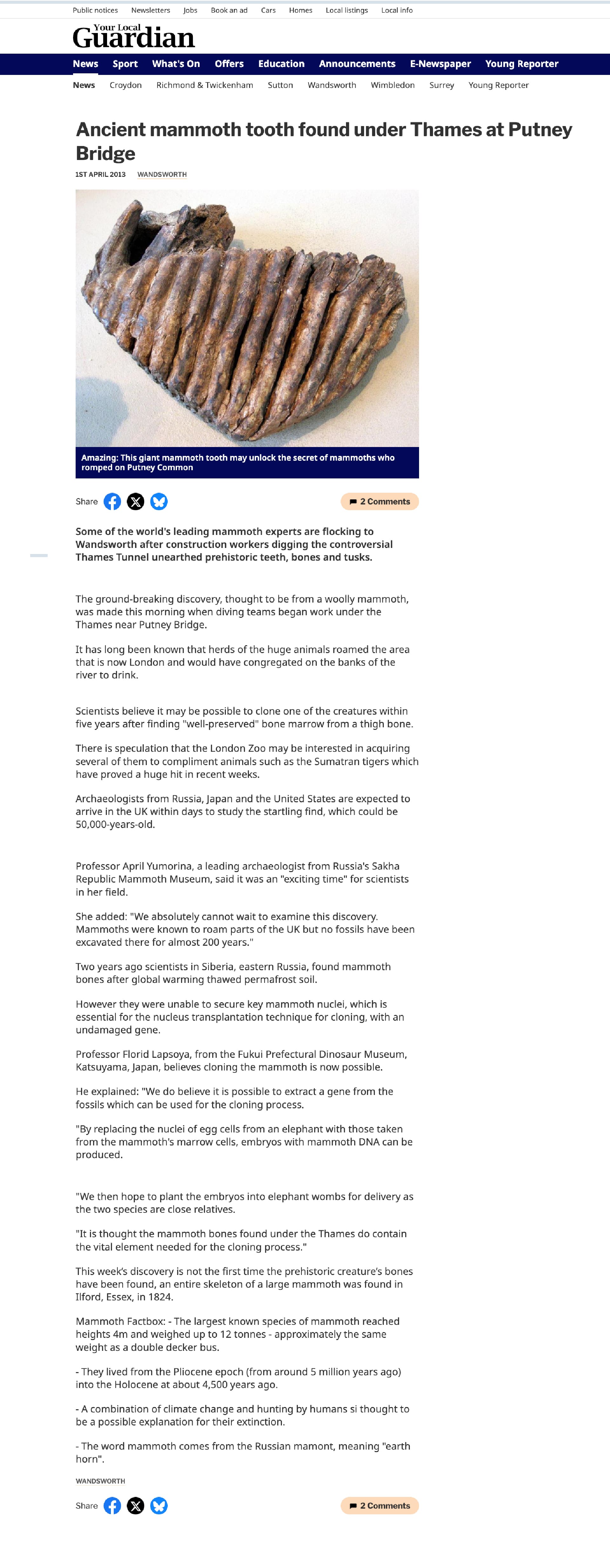
The ground-breaking discovery, thought to be from a woolly mammoth, was made this morning when diving teams began work under the Thames near Putney Bridge.
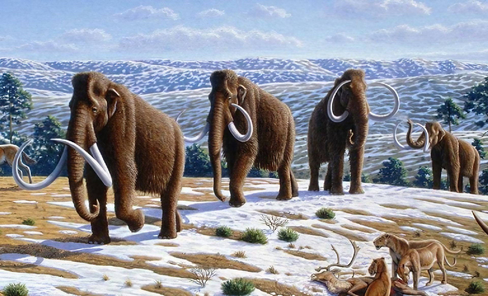
It has long been known that herds of the huge animals roamed the area that is now London and would have congregated on the banks of the river to drink . . .
[Your Local Guardian: Ancient mammoth tooth found under Thames at Putney Bridge.
So the world's leading mammoth experts were "flocking to Wandsworth" to see the "ground-breaking" (ho-ho) find. Really? Why?
The paper goes on to suggest that any DNA that could be extracted and used to re-create a mammoth.
Scientists believe it may be possible to clone one of the creatures within five years after finding "well-preserved" bone marrow from a thigh bone.
Yes, but this was a tooth, not a bone. Ah, but have a look at the date. Is it a spoof? I still don't know.
I tried digging into blogs of the period:
On 6/9/2013 mudlark76 wrote:
Yes . . . there was a lot of confusion at the time about whether this was or was not an April Fool's story — not helped by the fact that the local newspaper embellished the story with the usual rubbish about DNA and cloning.
Some reports mentioned other bones and tusks. Some didn't. All very unhelpful and I'm still not 100% sure — although the find wasn't reported in the NHM bulletins as far as I know (or at least not yet).
If it was an April Fool's joke it was an ill-advised choice of topic given that mammoth fossils including teeth have been reported from the London gravels (albeit rarely) in the past. For your find, my money would still be on Palaeoloxodon rather than Mammuthus taking frequency of finds into consideration.
[The Fossil Forum: Link.]
I'm not qualified to judge. I must ask Pamela Greenwood, our local expert on all things archaeological and palaeontological. Any thoughts, anyone?
22 August 2025: Mike Tuffrey responded:
As for the April Fool or not — great fun. Professor April Yumorina is a good one. WikiCommons says "Yumorina, Ukrainian: Гуморина is an annual festival of humor held in Odessa, Ukraine on and around the April Fools' Day since 1973."
PB: Wow, quite an elaborate hoax for a local newspaper, then — but that does seem to settle the question!
But there definitely have been mammoth finds in our area.
Here's a prime specimen of "An English Woolly Mammoth Tooth" found in the Wandsworth area in 1886, at auction at Christie's in 2016:
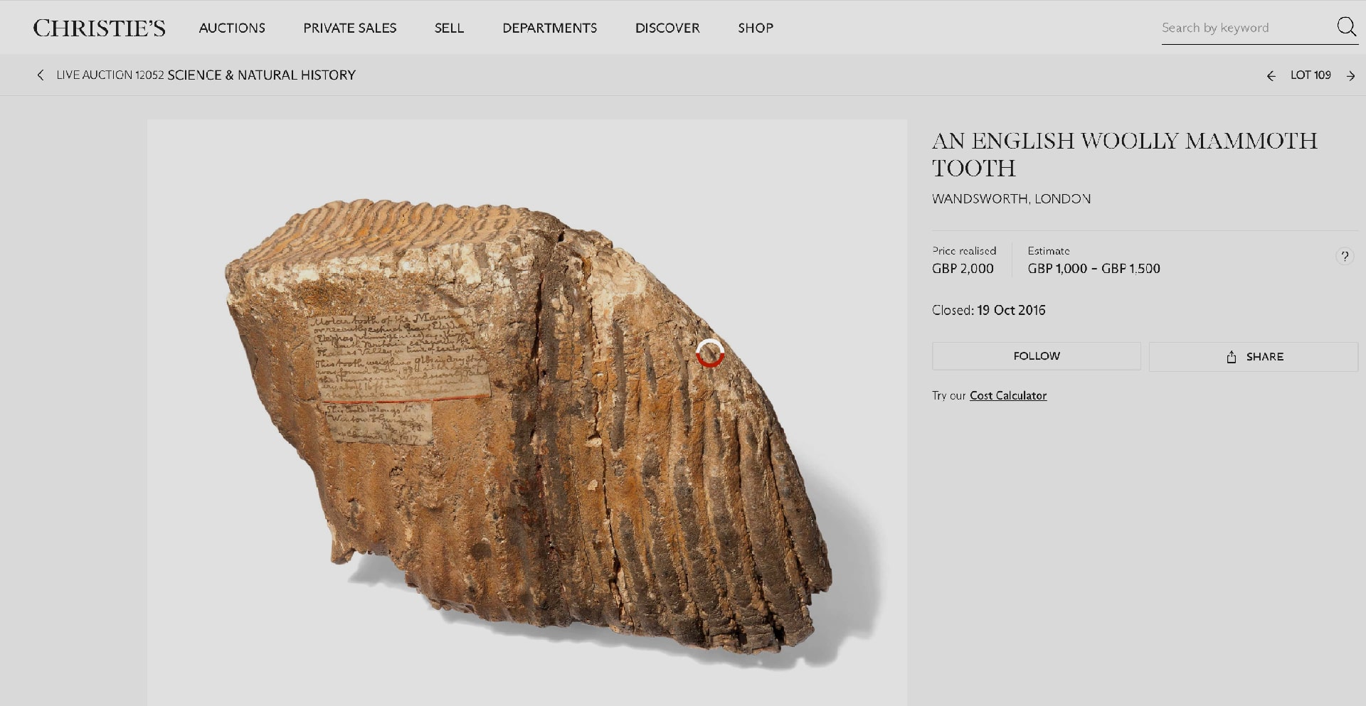
I've tried to enlarge the label. Can you read the text? Let me know if you can improve upon my transcription:
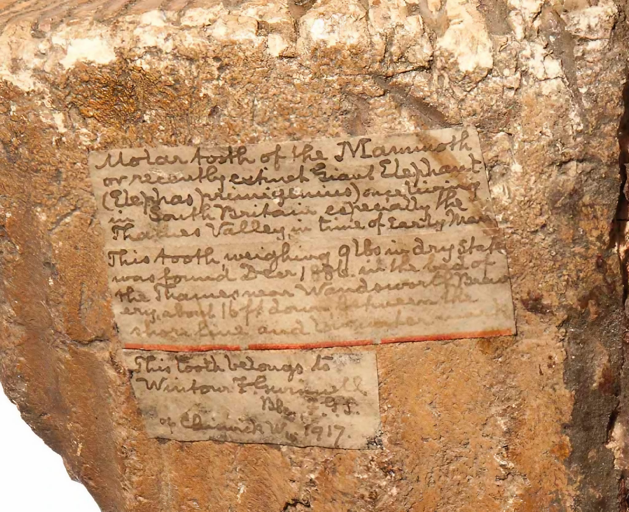
Molar tooth of the Mammoth
or recently extinct Giant Elephant
(Elephas primigenius) once living
in South Britain especially the
Thames Valley in time of Early Man.This tooth weighing 9lbs in dry state
was found Decr 1886 in the bed of
the Thames near Wandsworth Brew
ery about 16 ft down Between the
shore line and [illeg. — low water mark?]This tooth belongs to [Wintour F. Gurney?] F.G.S. [Fellow of the Geological Society]
of Chiswick W. [?] 1917.
There used to be a mammoth tooth on show in the Wandsworth Museum, which many of you will remember:
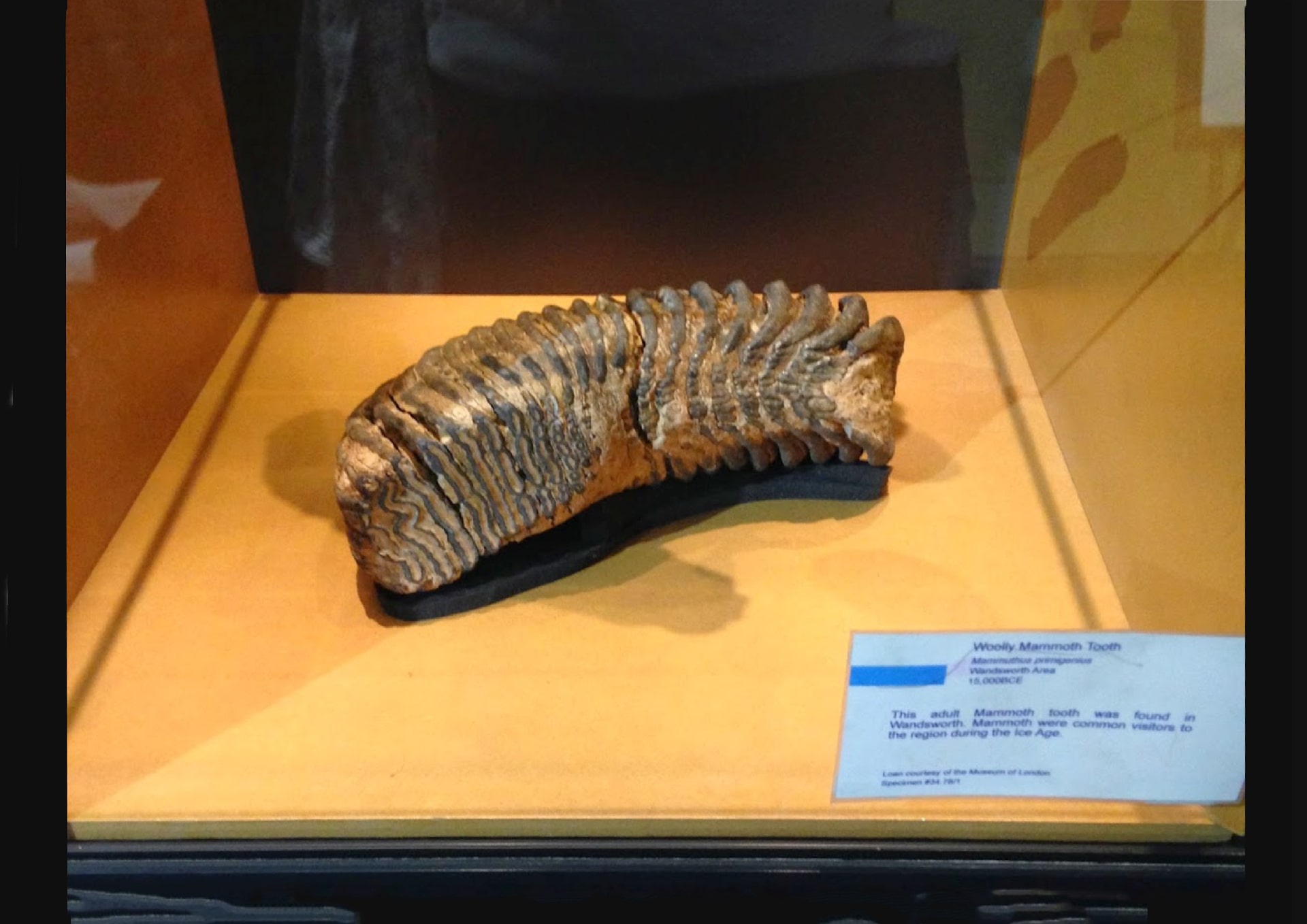
"Woolly Mammoth Tooth
Mammuthus primigenius [sic?]
Wandsworth area
15,000BCEThis adult Mammoth tooth was found in Wandsworth. Mammoths were common visitors to the region in the Ice Age.
Loan courtesy of the Museum of London.
[Specimen no. illegible.]
But again, we have to ask exactly where in the "Wandsworth area"?
The "Museum of London" (or at least the part once housed in the Barbican) has been closed for several years, which I greatly regret. But it's due to re-open next year as the London Museum at the former Smithfield Meat Market.
So far as the former Wandsworth Museum is concerned, I know lots of people are working extremely hard to catalogue and photograph all the items (of which there are more than 25,000). Eventually there will be a website. This alone will be immensely valuable. But with effort, money and luck there will also one day be a super new Wandsworth Museum that everyone can visit.
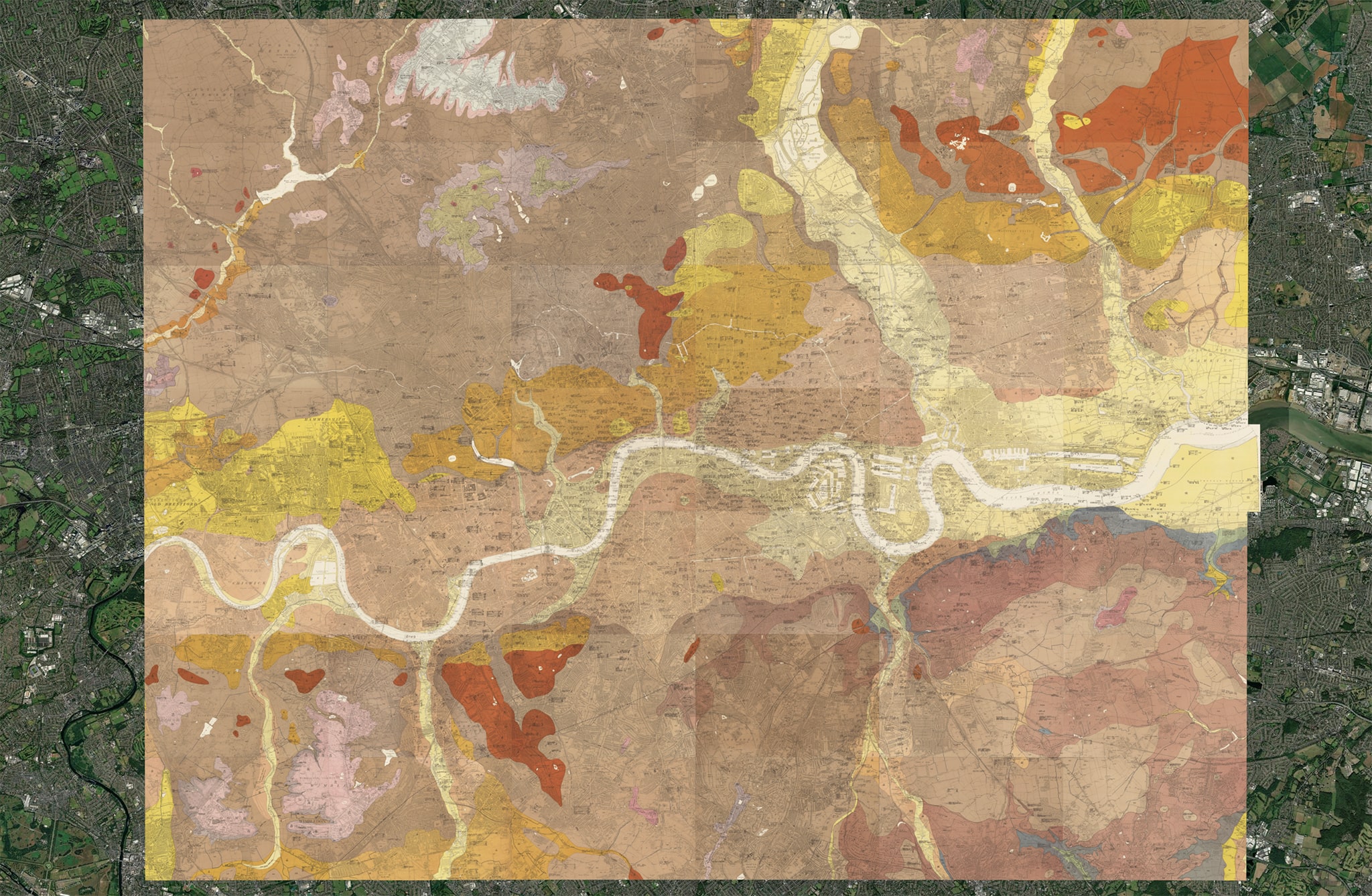
For understandable reasons, this month's map is geology-related and dates from the early 20th century. As we shall see, modern maps are very little different, though some (but not all) of the terms used to describe geological deposits and layers have changed.
Here's London as a whole:
Here is Battersea and Wandsworth east of the Wandle:
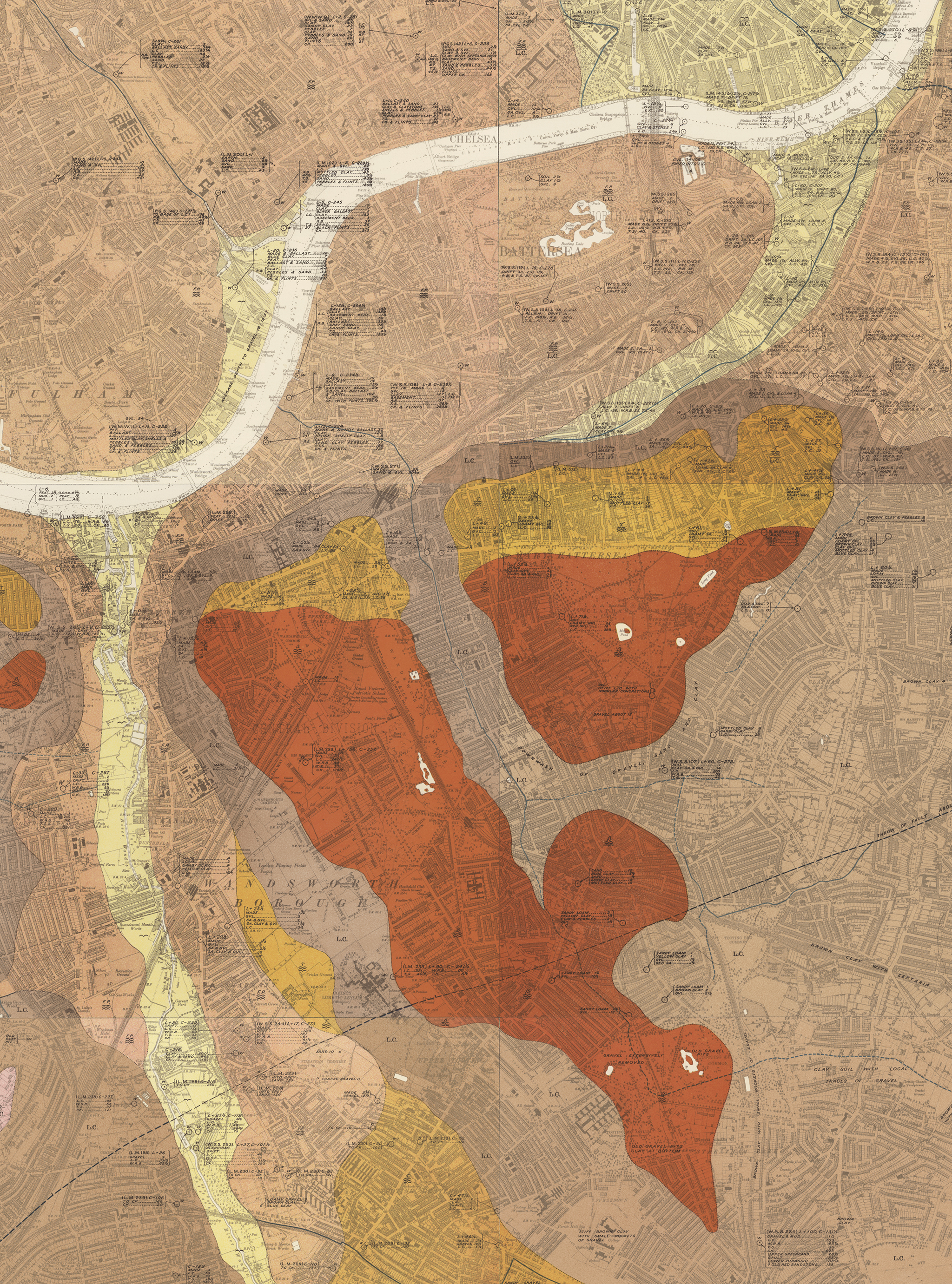
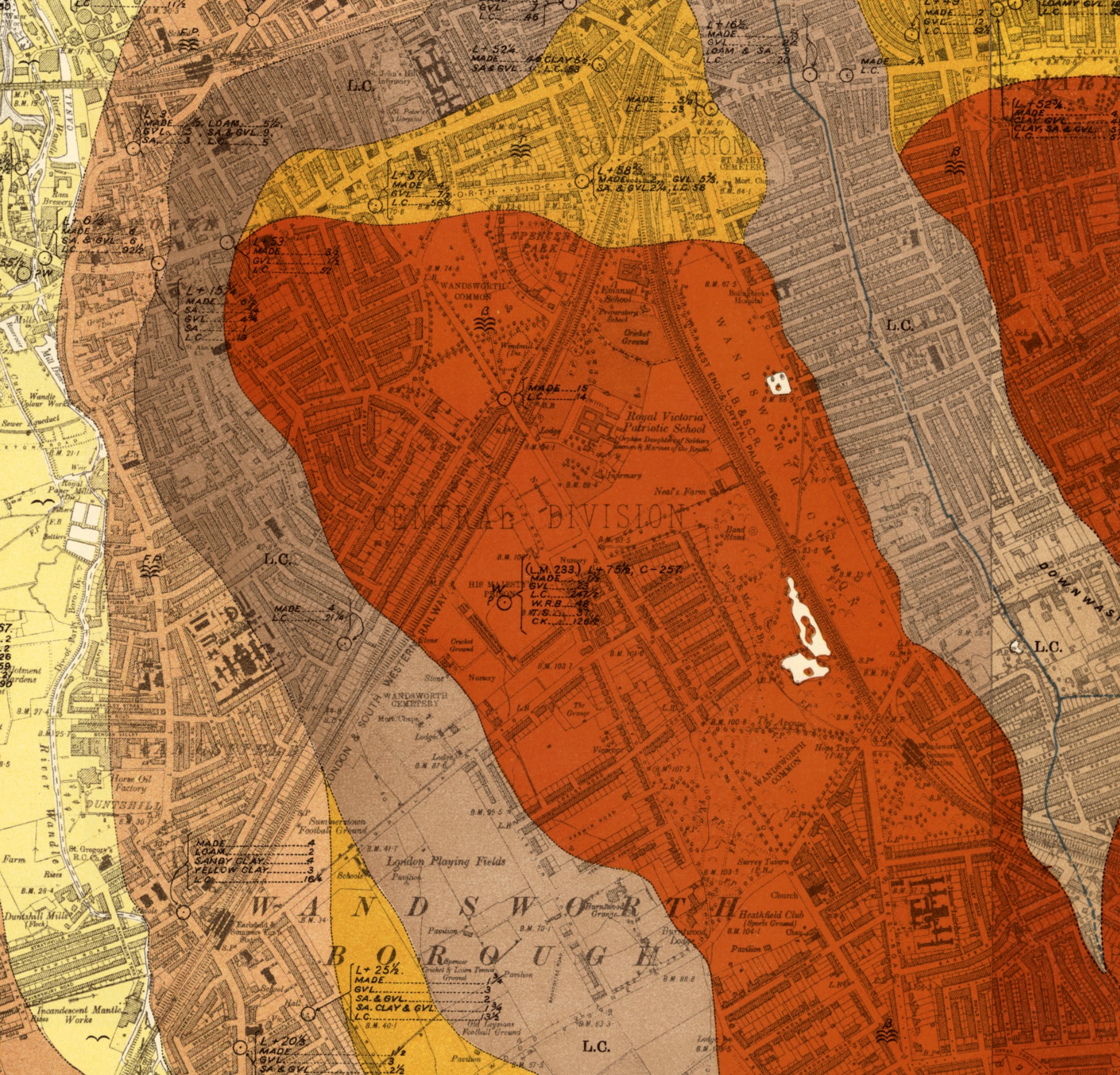
The colours indicate various surface deposits (sometimes called "Drift"). Notice how Wandsworth and Clapham Commons are similarly coloured (mainly chestnut-brown), as are parts of Islington in North London (and even larger areas in Essex). This is because they share a similar kind of gravel (which at this time was referred to as "Boyn Hill Gravel", after a suburb of Maidenhead where its particular mix of ingredients was first recognised).
The map distinguishes a number of different gravels (on which more below), plus clay, alluvium, and silt (sometimes called "brickearth"). Notice how clearly London's rivers stand out. These are associated with (yellow-tinted) alluvium — typically fertile deposits of clay, silt, fine gravel and sand carried down by running water and distributed over the adjacent land.
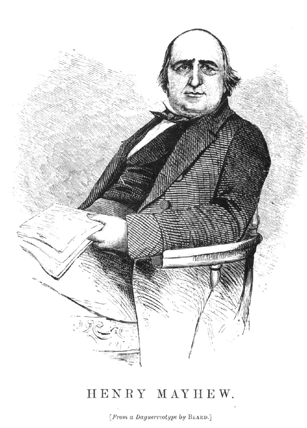
At some time in the middle of the 1850s, Henry Mayhew undertook a remarkable rail journey from central London to Wandsworth Prison which (given the many changes he perceived as he travels through city, suburban and rural landscapes), he likened to "the ascent of a mountain in the tropics, and gradual passage through the several atmospheric layers of different climates". (I assume in this he's following Alexander von Humboldt's 1807 discoveries about the vertical zonation of plants.)
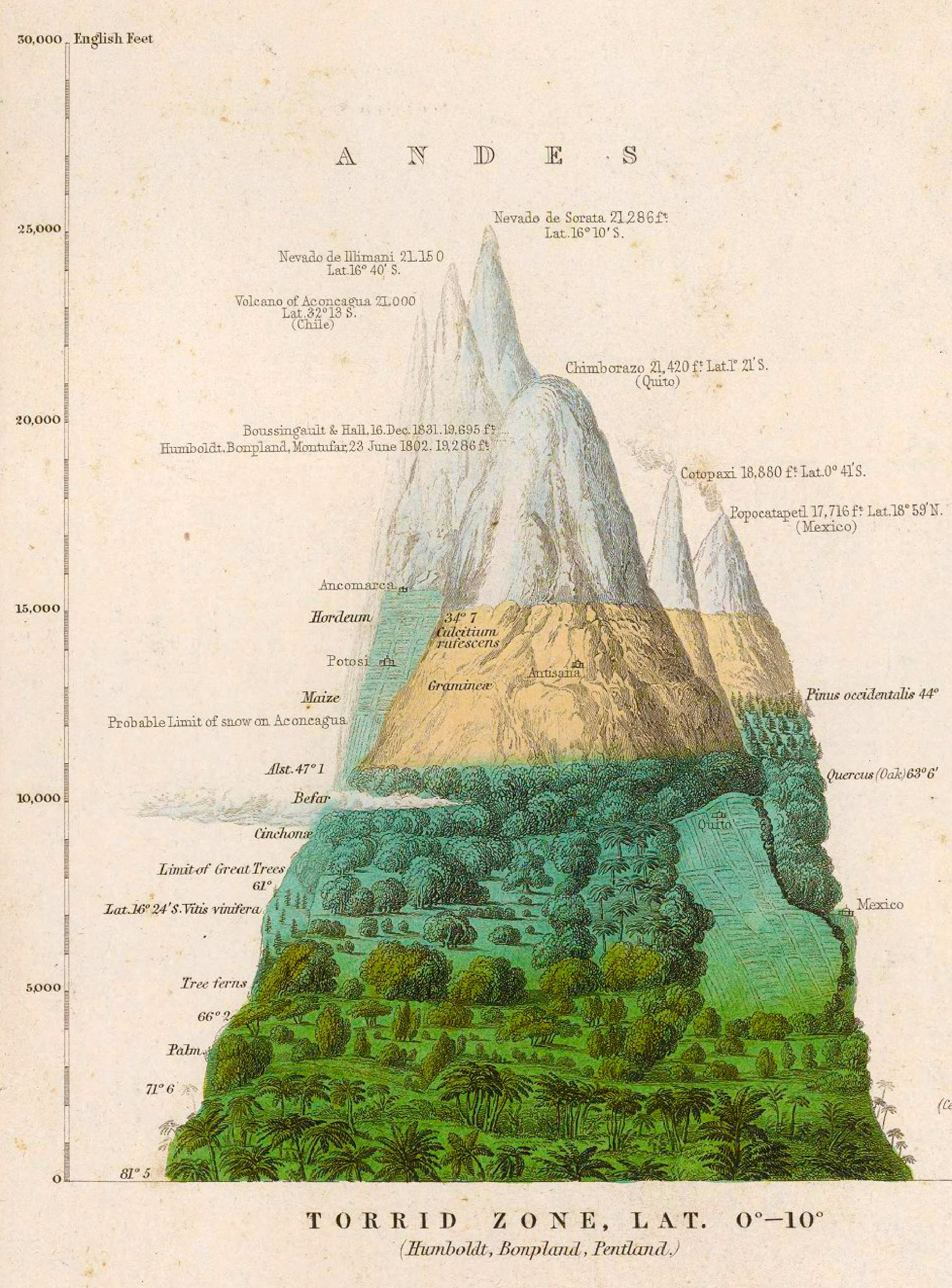
[This] reveals, as we rise above the plains, the mountain sides prismatically belted, as it were, with the rainbow hues of various zones of fruits and flowers — the same as if we had passed along rather than above the surface of the globe — from the brilliant and glowing tints of vegetable nature at the tropics, to the sombre shades of the hardier plants and trees peculiar to the colder regions, even till we ultimately reach, at the peak, the colourless desolation of the poles themselves.
But this journeying upwards through the various botanical strata, as it were, of the earth is hardly more peculiar and marked than is the rapid transition now-a-days, while travelling on some London railway, from town to the country; for as we fly along the house-tops through the various suburban zones encircling the giant Metropolis, we can see the bricken city gradually melt away into the green fields, and the streets glide, like solid rivers, into the roads, and cabs and busses merge into wagons and ploughs, while factories give place to market-gardens, and parks and squares fade gradually into woods and corn-fields.
Perhaps this change, from civic to rustic scenery — this dissolving view, as it were, of the capital melting into the country, is nowhere better seen than in a half-hour's trip along the Southampton rail [to the prison at Wandsworth Common].
I'll discuss his odyssey in more detail another time, but for now I'd like to note one his findings in the prison itself, the well. In this case, of course, the strata are deep below ground, rather than elevated high above it.
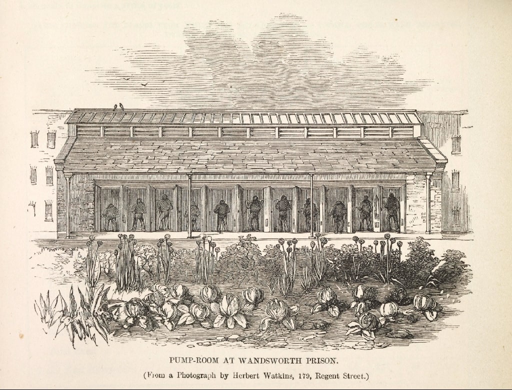
(Not to be confused with the Pump Room at Bath.)
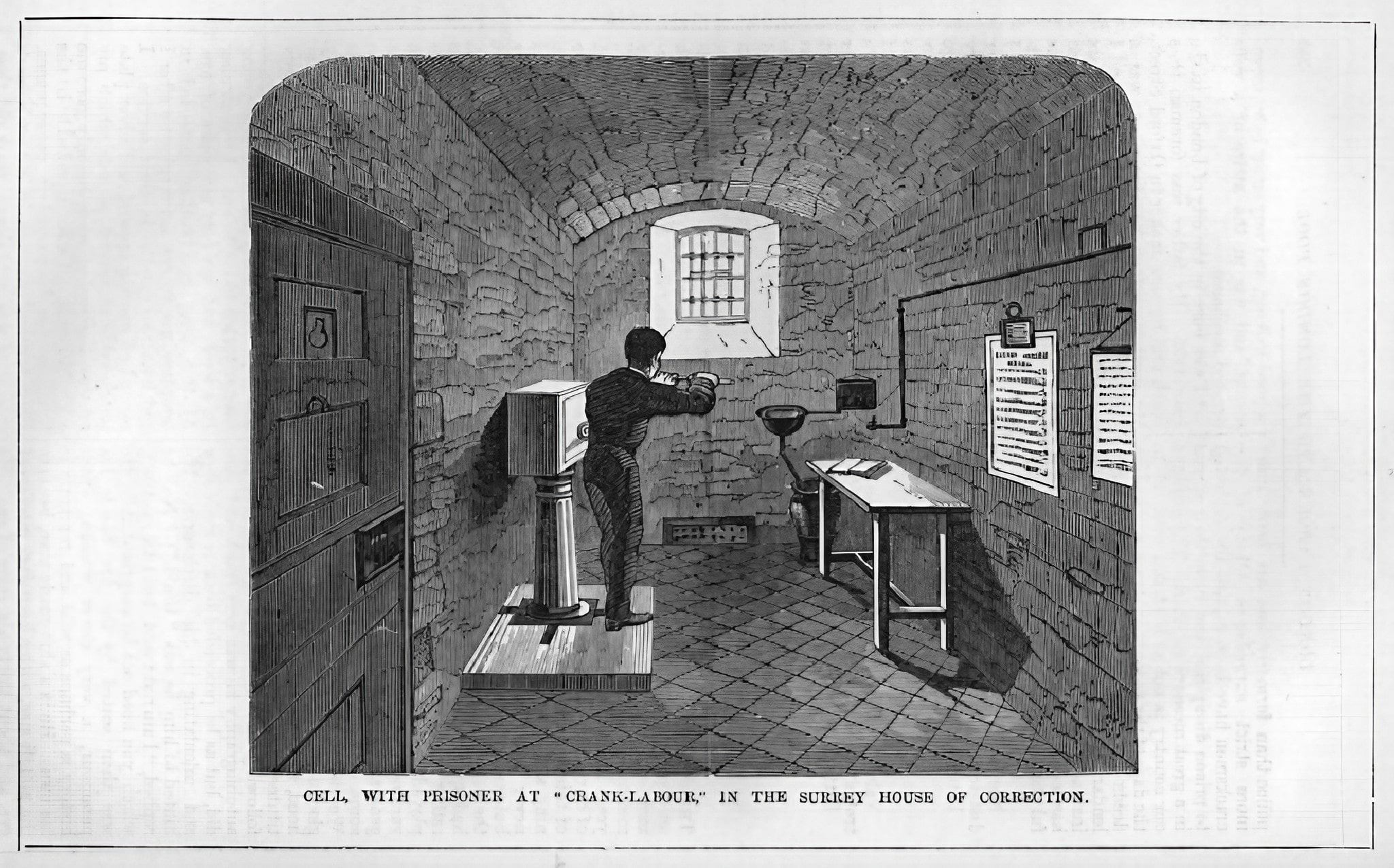
Notice in the top right quadrant of this contemporary engraving a small rectangular building standing alone near neat vegetable plots. This stands on top of the prison well, and houses the pumps.
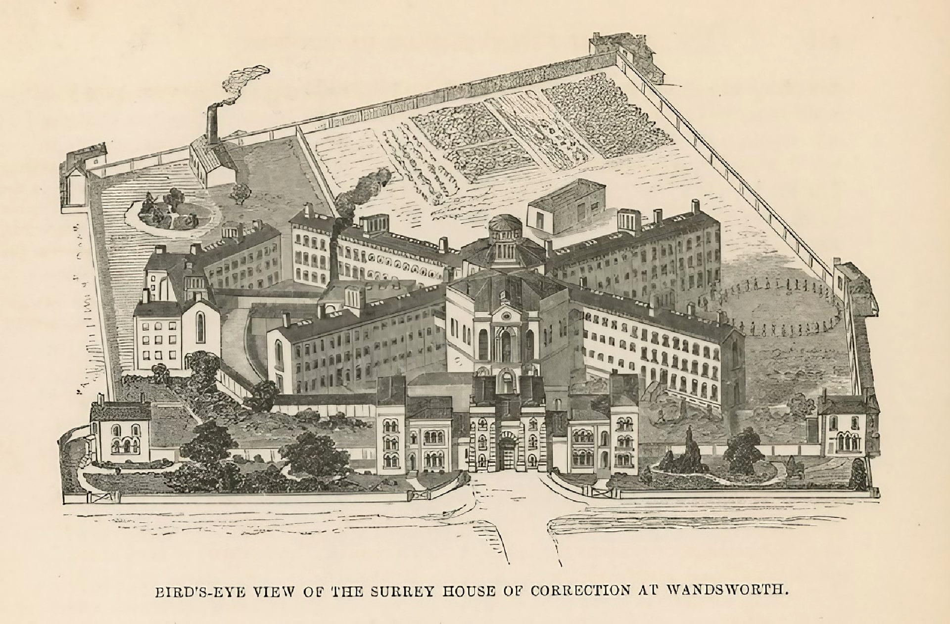
The prison, as Mayhew and his co-author John Binny note, is:
supplied by water drawn from an artesian well, 480 feet deep, immediately beneath the pump-house . . . The pump-house is an oblong building about 54 feet long and 32 feet broad. The machinery runs along the centre of the building.
There are twelve stalls on each side, each of them furnished with a handle connected with the central machinery, which, when set in motion, conveys the water into cisterns on the roof of the prison.
The prisoners are employed on these machines an hour at a time, and during that period rest three times for five minutes, so that they are kept working forty-five minutes . . . The number of revolutions performed at the pumps the day before our visit was 4703, which is about the average number."
[London Museum: Link.]
Incidentally, this is not to be confused with "crank labour" in Wandsworth's initially individual cells, which was designed to be effortful but utterly pointless; in short, to break the spirit. It did not supply water to the (then innovative) flushing lavatories in each cell — see one in the right hand corner.
There is a debate whether the lavatories were deliberately removed to create the space for "doubling up" — two prisoners to be housed in each cell. Possibly, but in any case the lavatories didn't work.
Let's look more closely at the prison as shown on our geological map, which shows a deep well within the prison walls:
Here's how Mayhew describes this well in an article on his visit to the prison (probably in the mid-1850s). The prison, he writes, is:
"supplied by water drawn from an artesian well, 480 feet deep, immediately beneath the pump-house . . . The pump-house is an oblong building about 54 feet long and 32 feet broad. The machinery runs along the centre of the building.
There are twelve stalls on each side, each of them furnished with a handle connected with the central machinery, which, when set in motion, conveys the water into cisterns on the roof of the prison.
The prisoners are employed on these machines an hour at a time, and during that period rest three times for five minutes, so that they are kept working forty-five minutes . . . The number of revolutions performed at the pumps the day before our visit was 4703, which is about the average number."
[London Museum: Link.]
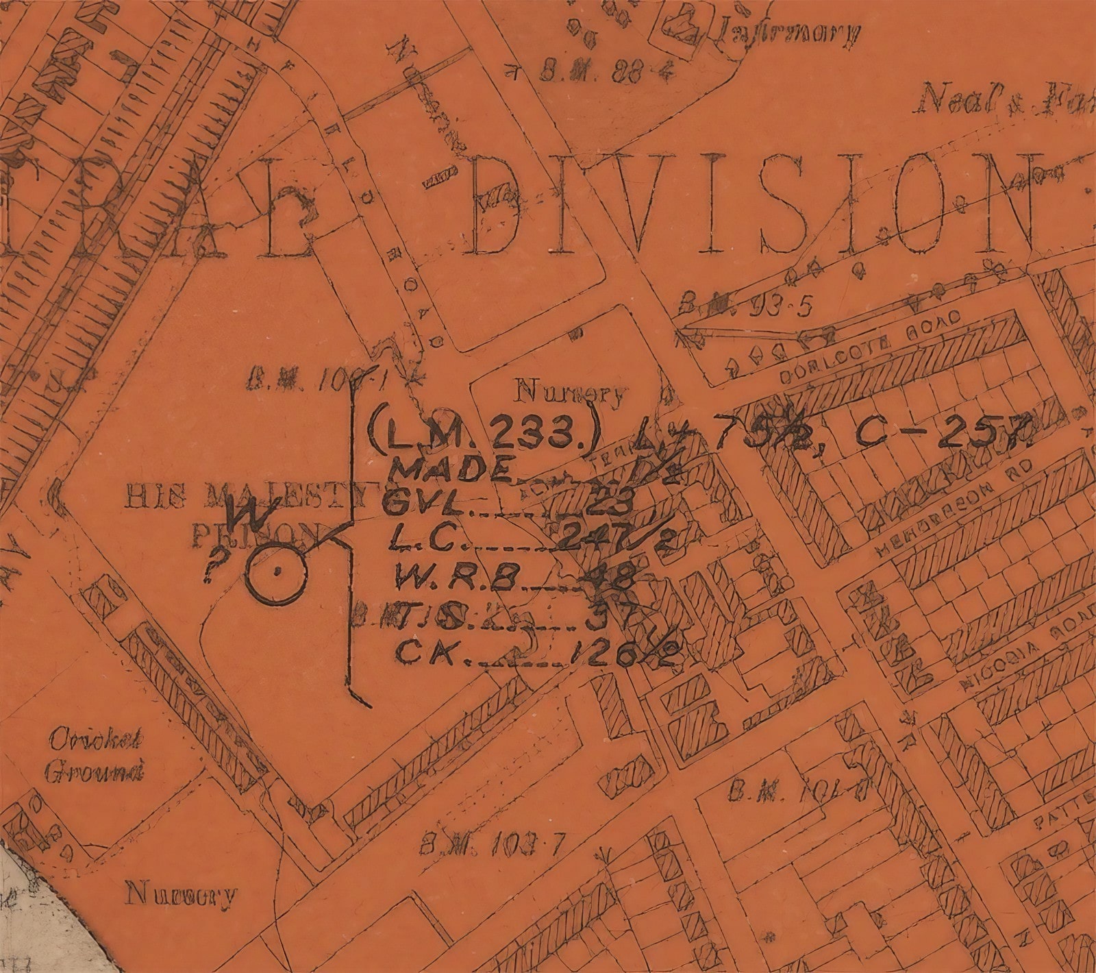
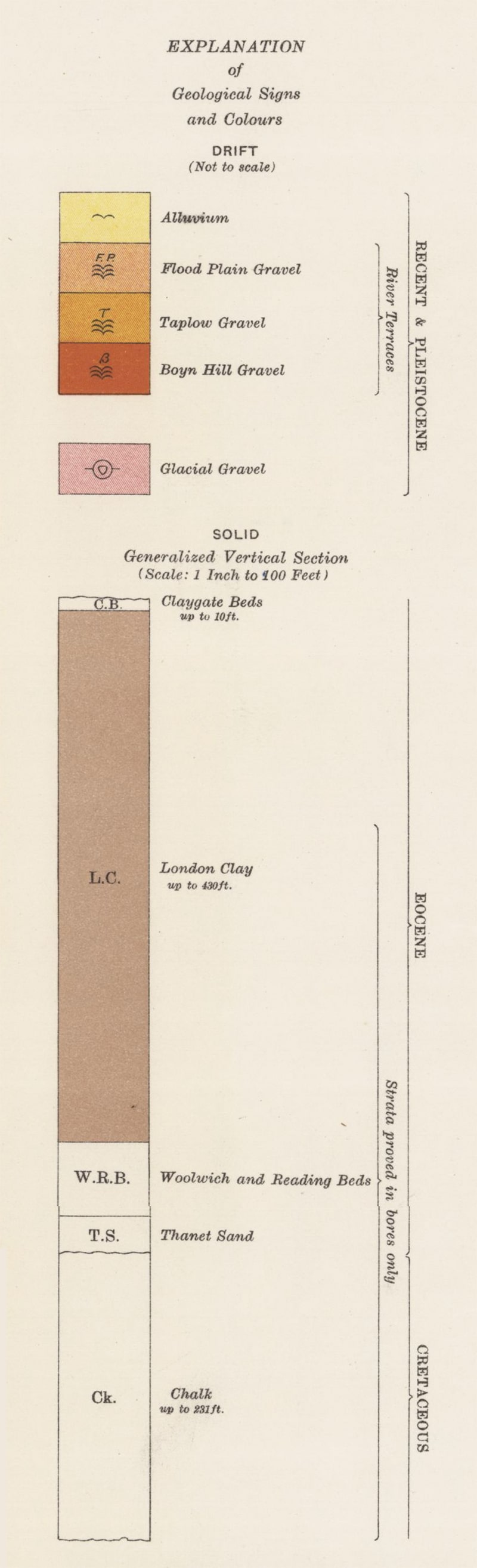
Which means:
— ⊙ (circle with dot in the middle): Borehole.
— W: Water.
— (L.M. 233.): London Memoir, The Geology of London, vol II, 1889, p.233.
— L+ 75 ½: Height in feet of the top surface of London Clay above Ordnance Datum (i.e. mean sea level at Newlyn, Cornwall).
— C- 257: Depth in feet of Chalk (surface) below Ordnance Datum.
Thickness of strata in feet:
— MADE: 1½ ft [an “artificial” surface made by humans from e.g. imported soil, spoil from digging, broken bricks and refuse].
— GVL: gravel=23 ft.
— LC: London Clay=247½ ft.
— WRB: Woolwich & Reading Beds=48 ft.
— TS: Thanet Sand=37 ft.
— CK: Chalk=126½ ft. [does this mean the layer of chalk is only 126½ feet here — if so, what lies beneath? The key says “Chalk up to 231 feet”.
Here's a similar listing of the strata, downloaded from the BGS site. Notice the well ceased to be used in 1911.
Are there any any signs of it today? I must ask historian of Wandsworth Prison Stewart McLaughlin.
For simplicity, I've labelled the different deposits. I won't go into any detail about the different surface deposits today, but the main point is that our local Commons — Wandsworth, Clapham, Tooting, Wimbledon — are as they are because all are topped by a cap of infertile gravel. It is this that made them Commons or uncultivated "wastes" in the first place (perhaps 1000 or more years ago) and kept them that way until the present.
SW-London-Geology-Viewer-BGS-tweaked-head-1920px-min.jpg SW-London-Geology-Viewer-BGS-tweaked-head-1024px-min.jpg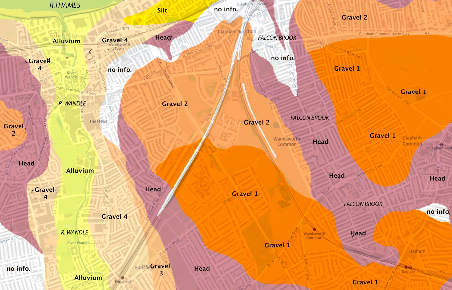
Modern names for rocks are sometimes different from those used in the 1913 map above. Gravels vary in their age, height above sea level, and their particular makeup. They differ, for example, in the average size, roundness or angularity of the small stones they're made up of. They take their name from "classic" sites in the Thames Valley where the particular mix was first described.
Unlike solid bedrock strata, on hills (such as Wandsworth, Clapham, or Wimbledon Commons) the oldest gravel layers are usually at the top of the pile. (Don't ask me why — at least not yet.)
Surface features
Layer after layer of sediments were laid down over our area, and cut into chiefly by rivers and streams.
The very top layer, where present, is often called Artificial ground, Made-ground, or just Made — i.e. "human-made".
Much of this is deposits of soil or landfill debris spread on the natural surface. On the Common, this can be up to about half a metre deep, but is usually shallower (or even absent). I often wonder when and how soil was added all over the Common. Where did it all come from?
Layers of Gravel can be up to 10 metres thick, but usually five metres or less. Huge amounts were stripped away in the nineteenth century, chiefly for making roads and buildings. The ponds on Wandsworth Common were once gravel pits.
There are several different sand/gravel layers in our area, laid down from more than 300 thousand years ago to the end of the last Ice Age about 11,700 years ago. The main ones in our area are:
Gravel 1 — Lynch Hill Gravel — the oldest.
Gravel 2 — Hackney Gravel.
Gravel 3 — Taplow Gravel.
Gravel 4 — Kempton Park Gravel — the youngest.
Head — a mixture mainly of sticky clay with silt, sand and gravel all jumbled together by the downward movement of material from higher layers.
Silt (sometimes called "Brickearth") — Langley Silt — clay and silt.
Alluvium — clay, silt, sand and gravel — formed since the end of last Ice Age.
Beneath all these deposited materials are the much older "Bedrocks".
These are London Clay, a layer of clay and silt up to 150 metres thick that formed around 50 million years ago.
Below that, 30 metres of Woolwich, Reading and Thanet Beds of very mixed materials, including shells, vegetable remains, clay, pebbles, sand, and flints.
And beneath all of the above lies Chalk, up to 200 metres thick, formed between 100 million and 61 million years ago. Over millennia huge volumes of water have percolated down Into this permeable layer that can be tapped by "artesian wells" such as the one beneath Wandsworth Prison.
Chalk often contains layers of Flints. There are no outcrops of chalk in our area, but most of the pebbles and gravels across our Common were once flint, pushed around, broken up, and smoothed by glaciers and flowing water.
There's loads more stuff below the Chalk too, but we've got to stop somewhere.
Perhaps, sometime in the future, we can look at other boreholes on and around the Common — most having been undertaken for the construction of wells, sewers, foundations of buildings, high-tension electricity cables, and even the possibility of running a train beneath our feet.

There's a lot more to be said about the fascination of local geology and topography, for example the sculpting of the landforms that underlie our Common and roads, and the durable perception (and reality) that this represents is a "healthy" area. But not now.
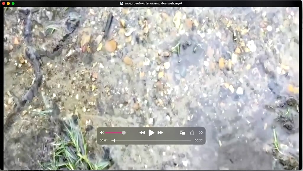
A few years ago, I made a 90-second video of water running over gravel on the side of the Avenue path near Bellevue Road:
THis list is a bit of a rag-bag at the moment, but I wanted to record some of the resources I'd come across in researching this month's Chronicles.
I'll almost certainly carry on trying to make sense of our local geology. And you may fancy doing the same.
— Learn more (much more) on the British Geology Society (BGS) website.
— Explore the BGS "Geology Viewer".
— BGS Borehole online map and records (GeoIndex Onshore).
— I expect D.R. Bridgland, Quaternary of the Thames (1994) is the bible of local geology. Thorough but very technical.
— Very good (easier, though still often beyond me), is R.A. Ellison et al, Geology of London. Memoir of the British Geological Survey, Sheets 256 (North London), 257 (Romford), 270 (South London) and 271 (Dartford). British Geological Survey. Online here.
— The Geology of London, compiled by Diana Clements. Geologists' Association Guide No. 68. Includes itineraries. I've only seen the introduction in an old edition, but even that was useful. There was a 2nd edition in 2024.
H Barron et al, London’s foundations: protecting the geodiversity of the capital , London, UK, Greater London Authority (pdf).
Over time, I'll add to this list. Let me know if you come across anything you find useful.
SO many more stories still to tell. But that's all for now, folks.
Send me an email if you enjoyed this post / want to comment on something you've seen on the site / would like to know more — or just want to be kept in touch.
If you would like to receive notifications of new Chronicles, let me know . . .
Philip Boys ("History Boys")
August 2025
— Friends of Wandsworth Common
— Wandsworth Historical Society
